Amazonis Planitia
|
Topographic map of Amazonis Planitia.]]
| |
| Coordinates | 24°48′N 196°00′E / 24.8°N 196.0°ECoordinates: 24°48′N 196°00′E / 24.8°N 196.0°E |
|---|---|


Amazonis Planitia is one of the smoothest plains on Mars. It is located between the Tharsis and Elysium volcanic provinces, to the west of Olympus Mons, in the Amazonis and Memnonia quadrangles, centered at 24°48′N 196°00′E / 24.8°N 196.0°E. The plain's topography exhibits extremely smooth features at several different lengths of scale.[1] A large part of the Medusae Fossae Formation lies in Amazonis Planitia.
Its name derives from one of the classical albedo features observed by early astronomers, which was in turn named after the Amazons, a mythical race of warrior women.
Age and composition
Only approximately 100 million years old, these plains provide some of the fewest sedimentary layers impeding viewing of the Martian terrain, and closely resemble the composition of Earth's Iceland. Formed by free-flowing lava across great plains, Amazonis has been described by William Hartmann as a "bright dusty volcanic desert crossed by many fresh-looking lava flows."[2]
Amazonis has become the primary focus of modern research efforts both because of its geological composition and because of its relative youth compared to other Martian regions, which are often hundreds of millions of years older.[3] Hartman writes that the plain closely resembles Iceland's surface, with its "strange cobweb-like networks of ridges and crags [on both planets, divide] smoother areas into a pattern something like fragments of a broken plate." Both land masses' shapes have been formed by lava flows from volcanic eruptions, causing both surfaces to be covered by a thick layer of hardened lava. Findings from aerial footage of both Amazonis and Iceland have shown nearly identical terrain patterns, signifying the comparative ages of the two regions.[4]
Ironically, the entire contemporary era on Mars has been named the Amazonian Epoch because researchers originally (and incorrectly) thought Amazonis Planitia to be representative of all Martian plains. Instead, over the past two decades, researchers have realized that the area's youth and extremely smooth surface actually distinguish the area from its neighbors. It is even possible that the area possessed distinctive characteristics when all of Mars was under water.[5]
Although the full implications of Amazonis's youth have not yet been determined, the nature of the area (i.e. lack of sedimentary rock) has at least provided researchers evidence that the areas are the most likely to provide future discoveries, and as such, has been proposed as a future site for most NASA landings.[6]
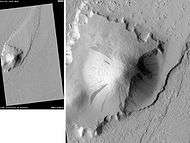
Medusae Fossae Formation
The Medusae Fossae Formation is a soft, easily eroded deposit that extends for nearly 1,000 km along the equator of Mars. The surface of the formation has been eroded by the wind into a series of linear ridges called yardangs. These ridges generally point in direction of the prevailing winds that carved them and demonstrate the erosive power of Martian winds. The easily eroded nature of the Medusae Fossae Formation suggests that it is composed of weakly cemented particles,[7]
-

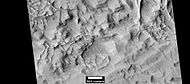
Plateau made up of Medusae Fossae materials and rootless cones, as seen by HiRISE.
-
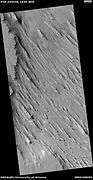
Yardangs, as seen by HiRISE under HiWish program Location is near Gordii Dorsum in the Amazonis quadrangle.
-
Yardangs near a crater, as seen by HiRISE under HiWish program Location is in the Amazonis quadrangle.
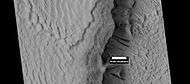
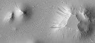
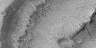
Linear ridge networks
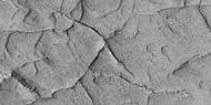
Linear ridge networks are found in various places on Mars in and around craters.[8] Ridges often appear as mostly straight segments that intersect in a lattice-like manner. They are hundreds of meters long, tens of meters high, and several meters wide. It is thought that impacts created fractures in the surface, these fractures later acted as channels for fluids. Fluids cemented the structures. With the passage of time, surrounding material was eroded away, thereby leaving hard ridges behind. Since the ridges occur in locations with clay, these formations could serve as a marker for clay which requires water for its formation.[9][10][11] Water here could have supported past life in these locations. Clay may also preserve fossils or other traces of past life.
-

Narrow ridges, as seen by HiRISE under HiWish program. The ridges may be the result of impacts fracturing the surface.
-

Linear ridge networks, as seen by HiRISE under HiWish program
-

Close-up of ridge network, as seen by HiRISE under HiWish program This is an enlargement of a previous image.
-
Close-up of ridge network, as seen by HiRISE under HiWish program This is an enlargement of a previous image.
-
Linear ridge networks, as seen by HiRISE under HiWish program
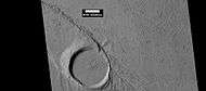
Streamlined shapes
When a fluid moves by a feature like a mound, it will become streamlined. Often flowing water makes the shape and later lava flows spread over the region. In the pictures below this has occurred.
-
Wide view of streamlined shape and rafts of lava, as seen by HiRISE under HiWish program
-
Closer view of previous image, showing layers, as seen by HiRISE under HiWish program
-

Close view of lava rafts from previous images, as seen by HiRISE under HiWish program
-
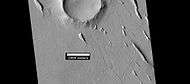
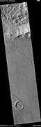
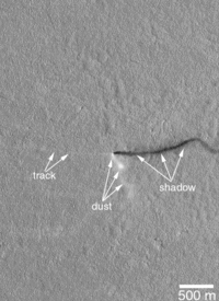
Streamlined Island in Marte Vallis, as seen by HiRISE. Click on image for good view of Dark Slope Streaks. Island is just to the west of Pettit Crater. Scale bar is 500 meters long.
-

Streamlined shape showing layers, as seen by HiRISE under HiWish program.
Dark slope streaks
-
Layers in Gordii Dorsum Region, as seen by HiRISE under HiWish program. Dark lines are Dark Slope Streaks.
-
Dark slope streaks on mesa, as seen by HiRISE under HiWish program Location is Amazonis quadrangle.
-

Dark slope streaks on mound in Lycus Sulci, as seen by HiRISE under HiWish program
More Images from Amazonis Planitia
-

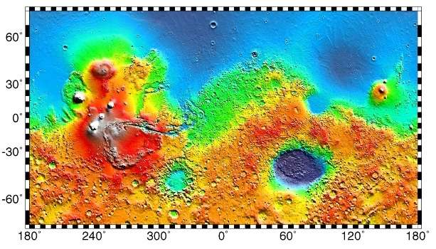
MOLA map showing boundaries for Amazonis Planitia and other regions Colors indicate elevations.
-
Martian Dust Devil - in Amazonis Planitia (April 10, 2001) (also) (video (02:19)).
-

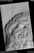
Possible inverted stream channels in Phlegra Dorsa region, as seen by HiRISE under HiWish program. The ridges were probably once stream valleys that have become full of sediment and cemented. So, they became hardened against erosion which removed surrounding material.
-
Surfaces in Amazonis quadrangle, as seen by HiRISE under HiWish program.
-

Layered features in Lycus Sulci, as seen by HiRISE under HiWish program
-
Wide view of scarp showing layers, as seen by HiRISE under HiWish program
-
Close view of layers from previous image, as seen by HiRISE under HiWish program
-

Layers in trough and dark slope streaks, as seen by HiRISE under HiWish program
-
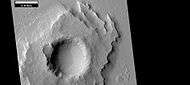
Pedestal crater with layers, as seen by HiRISE under HiWish program
Interactive Mars map
See also
- Amazonian (Mars)
- Dark slope streaks
- Geography of Mars
- List of plains on Mars
- Medusae Fossae Formation
References
- ↑ E. R. Fuller and J. W. Head, III, "GEOLOGIC HISTORY OF THE SMOOTHEST PLAINS ON MARS (AMAZONIS PLANITIA) AND ASTROBIOLOGICAL IMPLICATIONS." Lunar and Planetary Science XXXIII (2002). URL accessed 19 April 2006.
- ↑ Hartmann, William. A Traveler's Guide to Mars: The Mysterious Landscapes of the Red Planet. Workman Publishing: New York, 2003.
- ↑ Hartmann, 275.
- ↑ Hartmann, 286.
- ↑ Fuller, E.R. and J.W. Head III (2002), Amazonis Planitia: The role of geologically recent volcanism and sedimentation in the formation of the smoothest plains on Mars.
- ↑ Hartmann, 287.
- ↑ Grotzinger, J. and R. Milliken (eds.) 2012. Sedimentary Geology of Mars. SEPM
- ↑ Head, J., J. Mustard. 2006. Breccia dikes and crater-related faults in impact craters on Mars: Erosion and exposure on the floor of a crater 75 km in diameter at the dichotomy boundary, Meteorit. Planet Science: 41, 1675-1690.
- ↑ Mangold et al. 2007. Mineralogy of the Nili Fossae region with OMEGA/Mars Express data: 2. Aqueous alteration of the crust. J. Geophys. Res., 112, doi:10.1029/2006JE002835.
- ↑ Mustard et al., 2007. Mineralogy of the Nili Fossae region with OMEGA/Mars Express data: 1. Ancient impact melt in the Isidis Basin and implications for the transition from the Noachian to Hesperian, J. Geophys. Res., 112.
- ↑ Mustard et al., 2009. Composition, Morphology, and Stratigraphy of Noachian Crust around the Isidis Basin, J. Geophys. Res., 114, doi:10.1029/2009JE003349.
External links
| Wikimedia Commons has media related to Amazonis Planitia. |
- Google Mars zoomable map centered on Amazonis Planitia
- HiRISE image of faulting in Amazonis Planitia