Appoquinimink River
| Appoquinimink River | |
| River | |
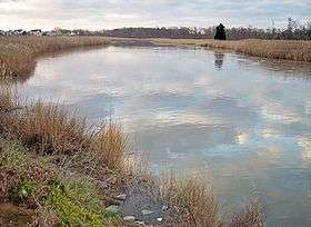 The Appoquinimink River in Odessa in 2006 | |
| Country | United States |
|---|---|
| State | Delaware |
| Source | |
| - location | Near Townsend |
| - elevation | 23 ft (7 m) (at Wiggins Mill Pond, approx. 1 mi/2 km downstream of source)[1] |
| - coordinates | 39°22′52″N 75°44′14″W / 39.38111°N 75.73722°W [2] |
| Mouth | Delaware Bay |
| - location | Near Odessa |
| - elevation | 0 ft (0 m) [2] |
| - coordinates | 39°26′52″N 75°34′49″W / 39.44778°N 75.58028°WCoordinates: 39°26′52″N 75°34′49″W / 39.44778°N 75.58028°W [2] |
| Length | 15 mi (24 km) [3] |
| Basin | 47 sq mi (122 km2) [4] |
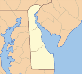 Location of the mouth of the Appoquinimink River
| |
The Appoquinimink River is a river flowing to Delaware Bay in northern Delaware in the United States. The river is 15.3 miles (24.6 km) long[3] and drains an area of 47 square miles (120 km2) on the Atlantic Coastal Plain.
The Appoquinimink flows for its entire length in southern New Castle County. It rises approximately 2 miles (3 km) west of Townsend and flows generally eastwardly, south of Middletown and past Odessa, to its mouth at the northern end of Delaware Bay, approximately 3 miles (5 km) east of Odessa.[5] In its upper course the river passes through two man-made lakes, Wiggins Mill Pond[1] and Noxontown Lake;[6] the river is tidal to the dam at Noxontown Lake, and salinity from Delaware Bay typically affects the lowermost 5 miles (8 km) of the river.[7] The lower 7 miles (11 km) of the river are considered to be navigable by the U.S. Army Corps of Engineers.[8]
It collects three named tributaries along its course:[5] From the north, Deep Creek, 4.2 miles (6.8 km) long[4] (also known historically as the "North Appoquinimink River"[9]); and Drawyers Creek,[10] 8.2 miles (13.2 km) long;[4] and from the south, Hangmans Run.[11]
According to 2002 data from the United States Environmental Protection Agency, 54.9% of the Appoquinimink River watershed is occupied by agricultural uses (predominantly soybeans, corn, and wheat); 15.1% is residential; 9.9% is wetland; and 8.8% is forested.[12]
In 2004, a non-profit group, The Appoquinimink River Association, was founded with a mission to protect the water and natural resources in the region surrounding the Appoquinimink River.[13]
Variant names and spellings
The United States Board on Geographic Names issued a decision clarifying the stream's name in 1950. According to the Geographic Names Information System, the Appoquinimink River has also been known historically as:[2]
|
|
|
See also
References
- 1 2 Geographic Names Information System. "GNIS entry for Wiggins Mill Pond (Feature ID #216865)". Retrieved 2007-02-05.
- 1 2 3 4 Geographic Names Information System. "GNIS entry for Appoquinimink River (Feature ID #213568)". Retrieved 2007-02-05.
- 1 2 U.S. Geological Survey. National Hydrography Dataset high-resolution flowline data. The National Map Archived 2012-04-05 at WebCite, accessed April 1, 2011
- 1 2 3 United States Environmental Protection Agency (December 2003). "Nutrient and Dissolved Oxygen TMDL Development for Appoquinimink River, Delaware.". p. 3. Retrieved 2007-02-05.
- 1 2 DeLorme (2004). Maryland Delaware Atlas & Gazetteer. p.61, pp.78-79. Yarmouth, Maine: DeLorme. ISBN 0-89933-279-X.
- ↑ Geographic Names Information System. "GNIS entry for Noxontown Lake (Feature ID #214395)". Retrieved 2007-02-05.
- ↑ United States Environmental Protection Agency (December 2003). "Nutrient and Dissolved Oxygen TMDL Development for Appoquinimink River, Delaware.". pp. 1–3. Retrieved 2007-02-05.
- ↑ U.S. Army Corps of Engineers, Philadelphia District. "Navigable waterways of the Philadelphia District.". Retrieved 2007-02-05.
- ↑ Geographic Names Information System. "GNIS entry for Deep Creek (Feature ID #213864)". Retrieved 2007-02-05.
- ↑ Geographic Names Information System. "GNIS entry for Drawyers Creek (Feature ID #213905)". Retrieved 2007-02-05.
- ↑ Geographic Names Information System. "GNIS entry for Hangmans Run (Feature ID #214053)". Retrieved 2007-02-05.
- ↑ United States Environmental Protection Agency (December 2003). "Nutrient and Dissolved Oxygen TMDL Development for Appoquinimink River, Delaware.". pp. Section Two, p.4. Retrieved 2007-02-05.
- ↑ "Appoquinimink River Association". Retrieved 2007-04-18.
External links
Dover (capital) | ||
| Topics |
|  |
| Society |
| |
| Cities | ||
| Towns |
| |
| Counties | ||