Arlington, Arizona
| Arlington, Arizona | |
|---|---|
| Census-designated place | |
|
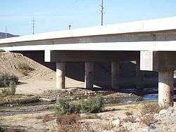
The historic Hassayampa Bridge. The bridge was built in 1929 and was modified and repaired in 1993. The bridge, which is described as a Concrete slab and girder, is located in the Old U.S. Highway Route 80 over the Hassayampa River between Salome Highway and 309 Ave. in the areas of Hassayampa and Arlington within the boundaries of the town of Buckeye, Az. The bridge was listed in the National Register of Historic Places in September 30, 1988, reference #88001658 | |
 Arlington, Arizona Location within the state of Arizona | |
| Coordinates: 33°19′32″N 112°45′51″W / 33.32556°N 112.76417°WCoordinates: 33°19′32″N 112°45′51″W / 33.32556°N 112.76417°W | |
| Country | United States |
| State | Arizona |
| County | Maricopa |
| Population (2010) | |
| • Total | 194 |
| Time zone | Mountain (MST) (UTC-7) |
| ZIP codes | 85322 |
Arlington is a census-designated place in Maricopa County, Arizona, United States, located about 40 miles west of Phoenix on old U.S 80. It follows the street numbering system of Phoenix. As of the 2010 census, the population was 194.
Demographics
As of the census[1] of 2010, there were 194 people residing in the CDP. The population density was 82.8 people per square mile. The racial makeup of the CDP was 69.07% White, 0.52% Black or African American, 1.55% Native American, 24.23% from other races, and 4.64% from two or more races. 29.90% of the population were Hispanic or Latino of any race.
References
- ↑ "Archived copy". Archived from the original on 2011-07-26. Retrieved 2013-10-18.
Municipalities and communities of Maricopa County, Arizona, United States | ||
|---|---|---|
| Cities | 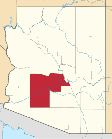 | |
| Towns | ||
| CDPs | ||
| Unincorporated communities |
| |
| Indian reservations | ||
| Ghost towns | ||
| Footnotes | ‡This populated place also has portions in an adjacent county or counties | |
This article is issued from Wikipedia - version of the 10/18/2016. The text is available under the Creative Commons Attribution/Share Alike but additional terms may apply for the media files.