Kaka, Arizona
| Kaka, Arizona O'odham: Gagka | |
|---|---|
| CDP | |
 Kaka, Arizona Location in the United States | |
| Coordinates: 32°30′32″N 112°18′59″W / 32.50889°N 112.31639°WCoordinates: 32°30′32″N 112°18′59″W / 32.50889°N 112.31639°W | |
| Country | United States |
| State | Arizona |
| County | Maricopa |
| Population (2010) | |
| • Total | 141 |
| Time zone | MST (no DST) (UTC-7) |
Kaka (O'odham: Gagka) is a census-designated place (CDP) in Maricopa County, Arizona, United States, located in the Tohono O'odham Nation. The population was 141 at the 2010 census.
Toponymy
It has frequently been noted on lists of unusual place names.[1]
Demographics
As of the census[2] of 2010, there were 141 people residing in the CDP. The population density was 545.0 people per square mile. The racial makeup of the CDP was 99.29% Native American and 0.71% from some other race. 6.38% of the population were Hispanic or Latino of any race.
Notes
Municipalities and communities of Maricopa County, Arizona, United States | ||
|---|---|---|
| Cities | 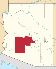 | |
| Towns | ||
| CDPs | ||
| Unincorporated communities |
| |
| Indian reservations | ||
| Ghost towns | ||
| Footnotes | ‡This populated place also has portions in an adjacent county or counties | |
This article is issued from Wikipedia - version of the 4/7/2016. The text is available under the Creative Commons Attribution/Share Alike but additional terms may apply for the media files.