Aroostook River
| Aroostook River | |
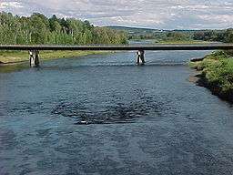 Aroostook River at Washburn, Maine | |
| Countries | United States, Canada |
|---|---|
| State | Maine |
| Province | New Brunswick |
| Cities | Ashland, Maine, Washburn, Maine, Presque Isle, Maine, Caribou, Maine, Fort Farfield, Maine |
| Source confluence | Millinocket Stream and Munsungan Stream |
| - location | Maine Township 8, Range 8, WELS, Penobscot County, Maine |
| - coordinates | 46°20′40″N 68°48′04″W / 46.3445°N 68.8011°W |
| Mouth | Saint John River (New Brunswick) |
| - location | Aroostook, NB |
| - elevation | 330 ft (101 m) |
| - coordinates | 46°48′36″N 67°42′58″W / 46.810123°N 67.71620°WCoordinates: 46°48′36″N 67°42′58″W / 46.810123°N 67.71620°W |
| Length | 112 mi (180 km) |
| Basin | 2,442.7 sq mi (6,327 km2) |
| Discharge | for Masardis, Maine |
| - average | 1,506 cu ft/s (43 m3/s) |
| - max | 29,500 cu ft/s (835 m3/s) |
| - min | 41 cu ft/s (1 m3/s) |
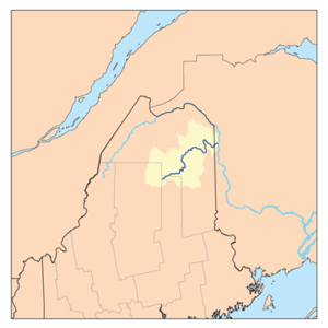 Aroostook River watershed
| |
| Watershed data.[1] | |
The Aroostook River is a 112-mile-long (180 km)[2] tributary of the Saint John River in the U.S. state of Maine and the Canadian province of New Brunswick. Its basin is the largest sub-drainage of the Saint John River.[3]
The river rises in northeastern Maine from the confluence of Millinocket Stream and Munsungan Stream in Maine Township 8, Range 8, WELS, in northern Penobscot County. The river winds east and northeast through Aroostook County. It runs through Ashland, and passes north of Presque Isle and east of Caribou. It joins the Saint John River in Aroostook, New Brunswick, 2 miles (3 km) after crossing the Canada–United States border.
The United States government maintains two river flow gages on the Aroostook. The first is located near Masardis, Maine (46°31′21″N 68°22′23″W / 46.52250°N 68.37306°W) where the rivershed is 892 square miles (2,310 km2). The second is at Washburn, Maine (46°46′36″N 68°09′29″W / 46.77667°N 68.15806°W) where the rivershed is 1,654 square miles (4,280 km2). By Fort Fairfield, Maine the rivershed is 2,301 square miles (5,960 km2). At Masardis, the maximum recorded flow is 29,500 cubic feet per second (840 m3/s) and the minimum 41 cubic feet (1.2 m3) per second.[4] At Washburn, the maximum recorded flow is 49,500 cubic feet (1,400 m3) per second and the minimum 75 cubic feet (2.1 m3) per second.[5] Annual maximum flows occur during the spring snow melt and minimums in the fall. The highest flood levels at both gages occurred during ice-dam induced floods, which occur relatively often on this river. Such flooding occurred in March and April 1999, April and May 2003, and April 2004.[6]
The river has a small run of Atlantic salmon. From 1998 to 2001 the number of adults returning to the river ranged from seventeen to thirty.[7]
The International Appalachian Trail runs along the river for several miles. Hikers cross the river, pass through customs, and cross the international boundary at Fort Fairfield, Maine.[8]
In the late 1830s, the territory comprising the river's drainage area was the scene of the Aroostook War, a boundary dispute between the United States and the United Kingdom.
See also
References
- ↑ University of Maine. "Watershed Overview and Data Access: Aroostook." Watershed Code 01010004. Accessed 2010-02-17.
- ↑ U.S. Geological Survey. National Hydrography Dataset high-resolution flowline data. The National Map Archived 2012-04-05 at WebCite, accessed June 22, 2011
- ↑ K. Elizabeth Gibbs; Billie Bradeen; Dan Boland (2004). "Spatial and Temporal Segregation Among Six Species of Coexisting Ophiogomphus (Odonata: Gomphidae) in the Aroostook River, Maine". Spatial and Temporal Segregation Among Six Species of Coexisting Ophiogomphus (Odonata: Gomphidae) in the Aroostook River, Maine. Retrieved 2006-05-07.
- ↑ U.S. Geological Survey (2008). "01015800 Aroostook River Near Masardis, ME" (PDF). Water-Data Report 2008. Retrieved 2010-02-17.
- ↑ U.S. Geological Survey (2008). "01017000 Aroostook River at Washburn, ME" (PDF). Water-Data Report 2008. Retrieved 2010-02-17.
- ↑ V.T. Hom; E.J. Capone & T.W. Econopouly (2004). "Table 1. Recent Ice Jam Events" (PDF). Forecasting Ice-Affected Rivers at the Northeast River Forecast Center. Retrieved 2006-05-07.
- ↑ Frederick W. Kircheis (2002). "Report of the Maine Atlantic Salmon Commission" (PDF). Report of the Maine Atlantic Salmon Commission. Archived (PDF) from the original on 21 May 2006. Retrieved 2006-05-07.
- ↑ "The International Appalachian Trail in Maine" (DOC). The International Appalachian Trail in Maine. Archived from the original on 2006-04-08. Retrieved 2006-05-07.
External links
| Wikimedia Commons has media related to Aroostook River. |
- USGS real-time river flow data at Washburn, Maine or Masardis, Maine. (Masardis also has air temperature.)
- See a panorama of the Aroostook River at Washburn
- National Weather Service forecast of river levels and flow.
- Real Time Aroostook River WebCam.
- "Aroostook River". Geographic Names Information System. United States Geological Survey. 30 September 1980. Retrieved 2009-10-22.