Auberry, California
- For the unincorporated community also called Auberry, see New Auberry, California.
| Auberry | |
|---|---|
| census-designated place | |
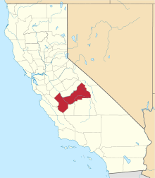
 Location in Fresno County and the state of California | |
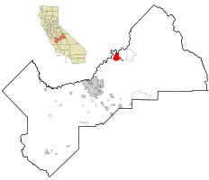
 Auberry Location in the United States | |
| Coordinates: 37°03′58″N 119°24′07″W / 37.06611°N 119.40194°WCoordinates: 37°03′58″N 119°24′07″W / 37.06611°N 119.40194°W | |
| Country |
|
| State |
|
| County | Fresno |
| Government | |
| • State Senator | Tom Berryhill (R)[1] |
| • State Assembly | Jim Patterson (R)[2] |
| • U. S. Congress | Tom McClintock (R)[3] |
| Area[4] | |
| • Total | 19.205 sq mi (49.740 km2) |
| • Land | 19.144 sq mi (49.582 km2) |
| • Water | 0.061 sq mi (0.158 km2) 0.32% |
| Elevation[5] | 2,018 ft (615 m) |
| Population (2010) | |
| • Total | 2,369 |
| • Density | 120/sq mi (48/km2) |
| Time zone | PST (UTC-8) |
| • Summer (DST) | PDT (UTC-7) |
| ZIP code | 93602 |
| Area code(s) | 559 |
| FIPS code | 06-03190 |
| GNIS feature IDs | 1657963, 2407779 |
Auberry is a census-designated place (CDP) in Fresno County, California, United States. The population was 2,369 at the 2010 census, up from 2,053 at the 2000 census. Auberry is located on Little Sandy Creek 9.5 miles (15 km) west of Shaver Lake Heights,[6] at an elevation of 2018 feet (615 m).[5]
Geography
According to the United States Census Bureau, the CDP has a total area of 19.2 square miles (50 km2), of which 19.1 square miles (49 km2) is land and 0.1 square miles (0.26 km2) (0.32%) is water.
Climate
Auberry has a Mediterranean climate (Köppen Cfa) with cool, rainy winters and hot, dry summers. Its average annual precipitation is 26.3 in (670 mm).[7] Its hardiness zone is 8a.[8]
| Auberry | ||||||||||||||||||||||||||||||||||||||||||||||||||||||||||||
|---|---|---|---|---|---|---|---|---|---|---|---|---|---|---|---|---|---|---|---|---|---|---|---|---|---|---|---|---|---|---|---|---|---|---|---|---|---|---|---|---|---|---|---|---|---|---|---|---|---|---|---|---|---|---|---|---|---|---|---|---|
| Climate chart (explanation) | ||||||||||||||||||||||||||||||||||||||||||||||||||||||||||||
| ||||||||||||||||||||||||||||||||||||||||||||||||||||||||||||
| ||||||||||||||||||||||||||||||||||||||||||||||||||||||||||||
History
The Auberry post office was established in 1884, and following moves in 1887 and 1888, it was located at its present site in 1906.[6] The place is named for Al Yarborough and is spelled phonetically as his name was pronounced.[6]
The Auberry Band of the Mono people was called ?unaħpaahtyħ , (that which is on the other side [of the San Joaquin River]) in the Mono language.[9]
Demographics
2010
The 2010 United States Census[10] reported that Auberry had a population of 2,369. The population density was 123.4 people per square mile (47.6/km²). The racial makeup of Auberry was 2,048 (86.4%) White, 10 (0.4%) African American, 105 (4.4%) Native American, 24 (1.0%) Asian, 2 (0.1%) Pacific Islander, 68 (2.9%) from other races, and 112 (4.7%) from two or more races. Hispanic or Latino of any race were 309 persons (13.0%).
The Census reported that 2,235 people (94.3% of the population) lived in households, 0 (0%) lived in non-institutionalized group quarters, and 134 (5.7%) were institutionalized.
There were 849 households, out of which 284 (33.5%) had children under the age of 18 living in them, 488 (57.5%) were opposite-sex married couples living together, 93 (11.0%) had a female householder with no husband present, 40 (4.7%) had a male householder with no wife present. There were 50 (5.9%) unmarried opposite-sex partnerships, and 3 (0.4%) same-sex married couples or partnerships. 188 households (22.1%) were made up of individuals and 83 (9.8%) had someone living alone who was 65 years of age or older. The average household size was 2.63. There were 621 families (73.1% of all households); the average family size was 3.04.
The population was spread out with 531 people (22.4%) under the age of 18, 187 people (7.9%) aged 18 to 24, 425 people (17.9%) aged 25 to 44, 746 people (31.5%) aged 45 to 64, and 480 people (20.3%) who were 65 years of age or older. The median age was 46.0 years. For every 100 females there were 98.4 males. For every 100 females age 18 and over, there were 96.6 males.
There were 949 housing units at an average density of 49.4 per square mile (19.1/km²), of which 646 (76.1%) were owner-occupied, and 203 (23.9%) were occupied by renters. The homeowner vacancy rate was 2.7%; the rental vacancy rate was 3.7%. 1,649 people (69.6% of the population) lived in owner-occupied housing units and 586 people (24.7%) lived in rental housing units.
2000
As of the census[11] of 2000, there were 2,053 people, 722 households, and 539 families residing in the CDP. The population density was 107.2 people per square mile (41.4/km²). There were 791 housing units at an average density of 41.3 per square mile (15.9/km²). The racial makeup of the CDP was 86.65% White, 0.44% Black or African American, 5.16% Native American, 0.73% Asian, 0.10% Pacific Islander, 2.05% from other races, and 4.87% from two or more races. 8.52% of the population were Hispanic or Latino of any race.
There were 722 households out of which 35.6% had children under the age of 18 living with them, 61.8% were married couples living together, 9.4% had a female householder with no husband present, and 25.3% were non-families. 21.3% of all households were made up of individuals and 10.0% had someone living alone who was 65 years of age or older. The average household size was 2.67 and the average family size was 3.12.
In the CDP the population was spread out with 26.3% under the age of 18, 6.2% from 18 to 24, 22.5% from 25 to 44, 26.2% from 45 to 64, and 18.9% who were 65 years of age or older. The median age was 42 years. For every 100 females there were 94.0 males. For every 100 females age 18 and over, there were 90.0 males.
The median income for a household in the CDP was $34,621, and the median income for a family was $42,083. Males had a median income of $36,172 versus $27,097 for females. The per capita income for the CDP was $18,106. About 9.4% of families and 13.8% of the population were below the poverty line, including 24.4% of those under age 18 and 17.6% of those age 65 or over.
References
- ↑ "Senators". State of California. Retrieved April 6, 2013.
- ↑ "Members Assembly". State of California. Retrieved April 6, 2013.
- ↑ "California's 4th Congressional District - Representatives & District Map". Civic Impulse, LLC. Retrieved April 6, 2013.
- ↑ "2010 Census U.S. Gazetteer Files – Places – California". United States Census Bureau.
- 1 2 "Auberry". Geographic Names Information System. United States Geological Survey.
- 1 2 3 Durham, David L. (1998). California's Geographic Names: A Gazetteer of Historic and Modern Names of the State. Clovis, Calif.: Word Dancer Press. p. 995-996. ISBN 1-884995-14-4.
- 1 2 "U.S. Climate Data". Retrieved 2013-12-02.
- ↑ PlantMaps hardiness zone for Auberry
- ↑ Sydney M. Lamb. 1957. Mono Grammar. University of California. Berkeley PhD dissertation. .pdf
- ↑ "2010 Census Interactive Population Search: CA - Auberry CDP". U.S. Census Bureau. Retrieved July 12, 2014.
- ↑ "American FactFinder". United States Census Bureau. Archived from the original on September 11, 2013. Retrieved 2008-01-31.