Sanger, California
| Sanger, California | |||
|---|---|---|---|
| City | |||
| City of Sanger | |||
|
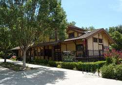
The Sanger Depot Museum is located in the old Sanger Railroad Depot | |||
| |||
| Motto: "The Nation's Christmas Tree City"[1] | |||
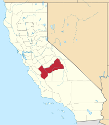
 Location in Fresno County and the U.S. state of California | |||
 Sanger, California Location in the United States | |||
| Coordinates: 36°42′29″N 119°33′21″W / 36.70806°N 119.55583°WCoordinates: 36°42′29″N 119°33′21″W / 36.70806°N 119.55583°W | |||
| Country | United States | ||
| State | California | ||
| County | Fresno | ||
| Founded | 1888[1] | ||
| Incorporated | May 9, 1911[2] | ||
| Government | |||
| • Mayor | Raul Cantu (Acting)[3] | ||
| • State Senator | Jean Fuller (R)[4] | ||
| • State Assembly | Joaquin Arambula (D)[5] | ||
| • U. S. Congress | David Valadao (R)[6] | ||
| Area[7] | |||
| • Total | 5.524 sq mi (14.307 km2) | ||
| • Land | 5.524 sq mi (14.307 km2) | ||
| • Water | 0 sq mi (0 km2) 0% | ||
| Elevation[8] | 371 ft (113 m) | ||
| Population (2010) | |||
| • Total | 24,270 | ||
| • Density | 4,400/sq mi (1,700/km2) | ||
| Demonym(s) | Sangarian | ||
| Time zone | PST (UTC-8) | ||
| • Summer (DST) | PDT (UTC-7) | ||
| ZIP code | 93657 | ||
| Area code(s) | 559 | ||
| FIPS code | 06-67056 | ||
| GNIS feature IDs | 277596, 2411811 | ||
| Website |
www | ||


Sanger is a city in Fresno County, California, United States. The population was 24,270 at the 2010 census, up from 18,731 at the 2000 census. Sanger is located 13 miles (21 km) east-southeast of Fresno,[9] at an elevation of 371 feet (113 m).[8]
Geography
According to the United States Census Bureau, the city has a total area of 5.5 square miles (14 km2), all land.
History
In 1886 the Southern Pacific Company referred to the area as Sanger Junction, concerning plans to improve access to the fertile land. Later the area was known simply as Sanger.[10] The name commemorates Joseph Sanger Jr., secretary-treasurer of the Railroad Yardmasters Association, who visited California in 1887.[9]
In 1888 The Pacific Improvement Company owned and sold lots on the site and the first post office opened.[9][10]
In 1890 the Kings River Lumber Company built a Log flume to transport lumber from the High Sierras to Sanger. That year more than 75 buildings were erected.[10]
The Sanger Railroad Depot was built in 1887 next to the Southern Pacific Railroad line that connected Fresno to Porterville. It is a Southern Pacific standard design Two Story Combination Depot No. 13 or 19.[11] Sanger became a center for shipping grain, citrus and lumber from the nearby mountains. When the depot was retired, it was the oldest building in the city and was donated to the Sanger Historical Society which turned it into the Sanger Depot Museum in 1977.[12]
By 1908 Sanger contained a grammar school, a high school, seven churches, two newspapers, an opera house, a bank, grain warehouses packing houses and two physicians.[10]
The city incorporated in 1911.[9]
In 1949, the city was designated the "Nation's Christmas Tree City" by the U.S. Postal Service.[1]
In May 2015, Mayor Joshua Mitchell resigned amid corruption allegations and alleged threats to him and his family.[12][13]
Demographics
| Historical population | |||
|---|---|---|---|
| Census | Pop. | %± | |
| 1920 | 2,578 | — | |
| 1930 | 2,967 | 15.1% | |
| 1940 | 4,017 | 35.4% | |
| 1950 | 6,400 | 59.3% | |
| 1960 | 8,072 | 26.1% | |
| 1970 | 10,088 | 25.0% | |
| 1980 | 12,542 | 24.3% | |
| 1990 | 16,839 | 34.3% | |
| 2000 | 18,931 | 12.4% | |
| 2010 | 24,270 | 28.2% | |
| Est. 2015 | 24,950 | [14] | 2.8% |

2010
The 2010 United States Census[16] reported that Sanger had a population of 24,270. The population density was 4,393.7 people per square mile (1,696.4/km²). The racial makeup of Sanger was 14,454 (59.6%) White, 219 (0.9%) African American, 311 (1.3%) Native American, 758 (3.1%) Asian, 39 (0.2%) Pacific Islander, 7,645 (31.5%) from other races, and 844 (3.5%) from two or more races. Hispanic or Latino of any race were 19,537 persons (80.5%).
The Census reported that 24,136 people (99.4% of the population) lived in households, 46 (0.2%) lived in non-institutionalized group quarters, and 88 (0.4%) were institutionalized.
There were 6,659 households, out of which 3,667 (55.1%) had children under the age of 18 living in them, 3,736 (56.1%) were opposite-sex married couples living together, 1,276 (19.2%) had a female householder with no husband present, 565 (8.5%) had a male householder with no wife present. There were 526 (7.9%) unmarried opposite-sex partnerships, and 49 (0.7%) same-sex married couples or partnerships. 894 households (13.4%) were made up of individuals and 459 (6.9%) had someone living alone who was 65 years of age or older. The average household size was 3.62. There were 5,577 families (83.8% of all households); the average family size was 3.90.
The population was spread out with 8,164 people (33.6%) under the age of 18, 2,559 people (10.5%) aged 18 to 24, 6,685 people (27.5%) aged 25 to 44, 4,575 people (18.9%) aged 45 to 64, and 2,287 people (9.4%) who were 65 years of age or older. The median age was 29.2 years. For every 100 females there were 97.4 males. For every 100 females age 18 and over, there were 95.6 males.
There were 7,104 housing units at an average density of 1,286.1 per square mile (496.5/km²), of which 3,873 (58.2%) were owner-occupied, and 2,786 (41.8%) were occupied by renters. The homeowner vacancy rate was 3.1%; the rental vacancy rate was 5.3%. 13,826 people (57.0% of the population) lived in owner-occupied housing units and 10,310 people (42.5%) lived in rental housing units.
2000
As of the census[17] of 2000, there were 18,931 people, 5,220 households, and 4,306 families residing in the city. The population density was 3,985.8 people per square mile (1,538.8/km²). There were 5,420 housing units at an average density of 1,141.1 per square mile (440.6/km²). The racial makeup of the city was 49.53% White, 0.42% Black or African American, 1.20% Native American, 1.96% Asian, 0.08% Pacific Islander, 43.16% from other races, and 3.64% from two or more races. 80.92% of the population were Hispanic or Latino of any race.
There were 5,220 households out of which 47.5% had children under the age of 18 living with them, 57.2% were married couples living together, 17.5% had a female householder with no husband present, and 17.5% were non-families. 14.3% of all households were made up of individuals and 8.4% had someone living alone who was 65 years of age or older. The average household size was 3.60 and the average family size was 3.91.
In the city the population was spread out with 34.1% under the age of 18, 11.6% from 18 to 24, 27.7% from 25 to 44, 16.6% from 45 to 64, and 10.1% who were 65 years of age or older. The median age was 28 years. For every 100 females there were 100.6 males. For every 100 females age 18 and over, there were 99.3 males.
The median income for a household in the city was $32,072, and the median income for a family was $33,219. Males had a median income of $26,443 versus $22,808 for females. The per capita income for the city was $11,625. About 21.0% of families and 23.7% of the population were below the poverty line, including 30.3% of those under age 18 and 15.7% of those age 65 or over.
Music and arts
In downtown Sanger is a mural of German born actress Nastassja Kinski, daughter of actor Klaus Kinski. This was created in 1982 by Sanger native artist Jose Maro Alvarado who now resides in the San Francisco Bay Area.
Notable people
- Earl J. Atkisson - World War I Colonel in the US Army
- Tom Flores - Professional football player and coach
- Manuel Neri - Artist
- Edward Dean Price - United States federal judge
- Francis Rogallo - Aeronautical engineer and inventor
Sanger High School
Sanger High School's Mascot is the Apache.
Sanger High School moved into a new facility at 1045 Bethel Avenue during the 1999-2000 school year. The Apache football team receives a large amount of fan support, along with their head coach Chuck Shidan.
References
- 1 2 3 "Sanger City History". City of Sanger. Retrieved April 6, 2013.
- ↑ "California Cities by Incorporation Date" (Word). California Association of Local Agency Formation Commissions. Retrieved April 6, 2013.
- ↑ "Welcome to the City Council". Retrieved April 6, 2013.
- ↑ "Senators". State of California. Retrieved April 6, 2013.
- ↑ "Members Assembly". State of California. Retrieved April 6, 2013.
- ↑ "California's 21st Congressional District - Representatives & District Map". Civic Impulse, LLC. Retrieved April 6, 2013.
- ↑ U.S. Census
- 1 2 "Sanger". Geographic Names Information System. United States Geological Survey.
- 1 2 3 4 Durham, David L. (1998). California's Geographic Names: A Gazetteer of Historic and Modern Names of the State. Clovis, Calif.: Word Dancer Press. p. 1102. ISBN 1-884995-14-4.
- 1 2 3 4 Lummis, Charles (1908). Out West, Volume 29. F. A. Pattee & Company.
- ↑ Bender, Henry E., Jr. (2013). Southern Pacific Lines Standard-Design Depots. Berkeley and Wilton, California: Signature Press. pp. 71–73. ISBN 9781930013339.
- 1 2 Home, Sanger Depot Museum, Acpleasecessed August 4, 2009.
- ↑
- ↑ "Annual Estimates of the Resident Population for Incorporated Places: April 1, 2010 to July 1, 2015". Retrieved July 2, 2016.
- ↑ "Census of Population and Housing". Census.gov. Retrieved June 4, 2015.
- ↑ "2010 Census Interactive Population Search: CA - Sanger city". U.S. Census Bureau. Retrieved July 12, 2014.
- ↑ "American FactFinder". United States Census Bureau. Retrieved 2008-01-31.
External links
| Wikimedia Commons has media related to Sanger, California. |