Banjarmasin
| Banjarmasin | ||||||||
|---|---|---|---|---|---|---|---|---|
| City | ||||||||
| Other transcription(s) | ||||||||
| • Chinese | 馬辰 | |||||||
Clockwise, from top left : Soetji Nurani Temple, Kayu Tangi roundabout, Sultan Suriansyah tomb complex, Muara Kuin Floating Market, Sabilal Muhtadin Mosque | ||||||||
| ||||||||
| Nickname(s): Kota Seribu Sungai (Indonesian: City of Thousand Rivers) | ||||||||
| Motto: Kayuh Baimbai (Banjarese: 'Rowing Together') | ||||||||
 | ||||||||
 Banjarmasin | ||||||||
| Coordinates: 3°20′S 114°35′E / 3.333°S 114.583°ECoordinates: 3°20′S 114°35′E / 3.333°S 114.583°E | ||||||||
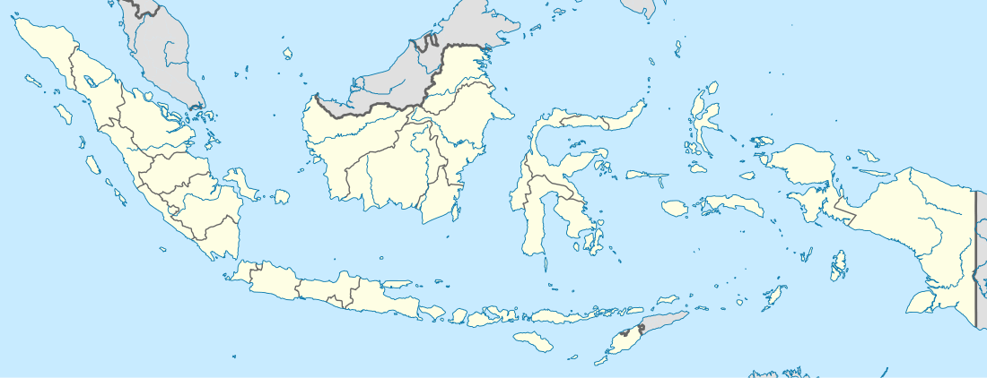
| Country | Indonesia | |||||||
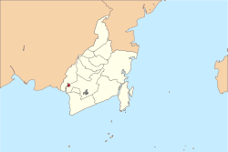
| Province | South Kalimantan | |||||||
| City | Banjarmasin | |||||||
| Subdistricts | 5 | |||||||
| Established | 24 September 1526 | |||||||
| Government | ||||||||
| • Mayor | Muhidin | |||||||
| Area | ||||||||
| • City | 98.46 km2 (38.02 sq mi) | |||||||
| • Metro | 3,404.46 km2 (1,314.47 sq mi) | |||||||
| Elevation | 1 m (3 ft) | |||||||
| Population (2010 Census) | ||||||||
| • City | 625,395 | |||||||
| • Density | 6,400/km2 (16,000/sq mi) | |||||||
| • Metro | 1,904,427 | |||||||
| Time zone | WITA (UTC+8) | |||||||
| Area code(s) | +62 511 | |||||||
| Website |
www | |||||||


Banjarmasin (aka Bandjermasin or Bandjarmasin, Chinese: 馬辰; pinyin: Mǎ chén) is the capital of South Kalimantan, Indonesia. It is located on a delta island near the junction of the Barito and Martapura rivers. As a result, Banjarmasin is sometimes called the "River City". Its population was 625,395 at the 2010 Census.
Economy
Main economic sectors include transportation and communication (26.1% of the city's GDP), processing industries (24.9%) and trade and commerce (16.5%). Main processing industries are: plywood, rattan and rubber manufacturing.
Administration
The city of Banjarmasin is divided into five districts (kecamatan), listed below with their population at the 2010 Census:[1]
| Name | Population Census 2010 |
|---|---|
| Banjarmasin Selatan (South Banjarmasin) | 146,068 |
| Banjarmasin Timur (East Banjarmasin) | 111,912 |
| Banjarmasin Barat (West Banjarmasin) | 143,461 |
| Banjarmasin Tengah (Central Banjarmasin) | 91,700 |
| Banjarmasin Utara (North Banjarmasin) | 132,340 |
Infrastructure and transport
Banjarmasin is served by the Syamsudin Noor Airport, located about 25 km outside the town. The town is served by a deepwater port, Trisakti Harbour, which is the centre of the Barito basin; exports include rubber, pepper, timber, petroleum, coal, gold, and diamonds. Passenger ships and ferries to and from Java also carry their operation here.
The city is laced with flood-prone waterways, and many houses are built on rafts or stilts over the water. The waterways are also used for travel, using relatively small rowboats (only major rivers are accessible by larger speedboats, tugboats, longboats, and barges).
Demographics
96% of the population is Muslim. Other religions include Protestants, Catholics, Hindus and Buddhists. Banjarese are the majority in the city, with Javanese, Madurese and other ethnics are the minority.[2] The city is the home of the Roman Catholic Diocese of Banjarmasin.
History

Nan Serunai was an ancient kingdom in South Kalimantan, but soon it was replaced by Buddhist kingdom of Tanjungpuri. In the fourteenth century, Banjarmasin was part of the Hindu kingdoms of Negara Dipa and Negara Daha, a vassal of Majapahit. But Pangeran Samudera converted to become a Muslim in the fifteenth century. Following this Banjarmasin was founded at the junction of the Barito and Martapura Rivers on 24 September 1526. The Dutch opened trade there in 1606. The British controlled the city for several brief periods. The British East India Company (EIC) started trading with the city, which they called Tamborneo or Tomborneo, in 1614. In 1703 the EIC established a factory there, which the inhabitants destroyed four years later. The EIC attempted, highly unsuccessfully, to trade with the city between 1736 and 1746, and then in 1747 the Sultan signed a treaty with the Dutch giving them a trade monopoly.[3]
In 1787 it became a Dutch protectorate. Banjarmasin remained the region's capital until the onset of the Banjarmasin War in 1859, when the Dutch headquarters were moved to Martapura.[4]

The Hikayat Banjar is the chronicle of Banjarmasin. This text, also called the History of Lambung Mangkurat, contains the history of the kings of Banjar and of Kota Waringin in South-east and South Borneo respectively.
In 1930 the city's population was 66,000 and reached 444,000 in 1990.[5]
Banjarmasin was the capital of Dutch Borneo. It was therefore an objective for the Japanese during Japanese Occupation of Indonesia during World War II. Banjarmasin was occupied on 10 February 1942.[6]
Greater Banjarmasin
The metropolitan area, known as Banjar Bakula, consists of the cities of Banjarmasin and Banjarbaru, and the regencies of Banjar, Barito Kuala and Tanah Laut in South Kalimantan. This metropolitan area covers an area of 3,404.46 square km, and at the 2010 Census has a population of 1,924,427.
Climate
Under the Köppen climate classification, Banjarmasin features a tropical rainforest climate. Temperatures are relatively constant throughout the year, averaging about 27 degrees Celsius, and the city has no real dry season. However Banjarmasin has noticeably wetter and drier times of the year. November through May forms the wettest part of the year with monthly precipitation of 200 millimetres (7.9 in) or more per month. June through October is drier with monthly precipitation of about 120 millimetres (4.7 in) per month. Banjarmasin on average sees just under 2,600 millimetres (100 in) of rain per year.
| Climate data for Banjarmasin | |||||||||||||
|---|---|---|---|---|---|---|---|---|---|---|---|---|---|
| Month | Jan | Feb | Mar | Apr | May | Jun | Jul | Aug | Sep | Oct | Nov | Dec | Year |
| Average high °C (°F) | 29 (85) |
29 (85) |
30 (86) |
31 (87) |
31 (88) |
31 (87) |
31 (87) |
31 (88) |
31 (88) |
31 (88) |
31 (87) |
29 (85) |
31 (87) |
| Average low °C (°F) | 25 (77) |
25 (77) |
24 (76) |
26 (78) |
26 (78) |
25 (77) |
24 (75) |
24 (75) |
24 (75) |
25 (77) |
25 (77) |
24 (76) |
24 (76) |
| Average precipitation mm (inches) | 350 (13.78) |
300 (11.81) |
310 (12.2) |
210 (8.27) |
200 (7.87) |
120 (4.72) |
120 (4.72) |
110 (4.33) |
130 (5.12) |
120 (4.72) |
230 (9.06) |
290 (11.42) |
2,570 (101.18) |
| Source: http://www.weatherbase.com/weather/weather.php3?s=58669&refer=&units=metric | |||||||||||||
Places of interest
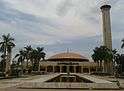
The Sabilal Muhtadin Mosque, located along the Martapura riverfront, is a major landmark in the city. Completely built in 1979, the mosque accommodates thousands of worshippers on Friday prayers.
A state university (Universitas Lambung Mangkurat, UNLAM) is also located in the town.
A floating marketplace, where buyers and sellers meet each other using boats, is located on the western outskirts of town. It is a traditional market and is considered one of city's identity mark for years.
Banjarmasin has long been renowned as a center for gem trading, particularly rare diamonds and rubies. An informal network with international connections exists, which also supports the large domestic Indonesian trade in rare diamonds. Banjar's diamonds are especially known for their exquisite brilliance. In recent times, however, many of Indonesia's large diamond stones have been traded out of the country.
Culinary
A local dish is "soto banjar", a soup served with lime. Another notable local dish is "Ketupat Kandangan", a ketupat dish with coconut milk soup (can be served with either chicken or snakehead fish meat).
Sport
The city's professional football club called Barito Putra.
References
- Eliot, Joshua (1998). Indonesia handbook. Bath: Footprint Handbooks Ltd.
- ↑ Biro Pusat Statistik, Jakarta, 2011.
- ↑ Kalsel Statistics: Religion, Retrieved 6 September 2009
- ↑ Long, George (1835) The Penny Cyclopædia of the Society for the Diffusion of Useful Knowledge: v. 1-27. (C. Knight). Vol. 3, p.375.
- ↑ Muller Kal:Indonesian Borneo, Kalimantan, Periplus Editions, Singapore 1992, ISBN 0-945971-09-5
- ↑ Brookfield, Harold et al: In Place of the Forest: Environmental and Socio-economic Transformation in Borneo and the Eastern Malay Peninsula, United Nations University Press, Tokyo, 1995
- ↑ L, Klemen (1999–2000). "The capture of Bandjermasin". Forgotten Campaign: The Dutch East Indies Campaign 1941-1942.
External links
| Wikisource has the text of the 1911 Encyclopædia Britannica article Banjermasin. |
| Wikimedia Commons has media related to Banjarmasin. |
-
 Banjarmasin travel guide from Wikivoyage
Regencies and cities of South Kalimantan | ||
|---|---|---|
Capital: Banjarmasin | ||
| Regencies | ||
| Cities | ||