Barron Falls
| Barron Falls Din Din | |
|---|---|
|
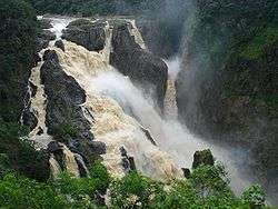
Barron Falls in the wet season. | |
 | |
| Location | Atherton Tablelands, Queensland, Australia |
| Coordinates | 16°50′19″S 145°38′45″E / 16.83861°S 145.64583°ECoordinates: 16°50′19″S 145°38′45″E / 16.83861°S 145.64583°E[1][2] |
| Type | Steep Tiered Cascade |
| Total height | 125 metres (410 ft)[3] |
| Number of drops | 4 |
| Longest drop | 107 metres (351 ft)[3] |
| Total width | 259 metres (850 ft)[3] |
| Watercourse | Barron River |
| Average flow rate | 30 centimetres per second (12 in/s)[3] |
The Barron Falls (Aboriginal: Din Din[4]) is a steep tiered cascade waterfall on the Barron River located where the river descends from the Atherton Tablelands to the Cairns coastal plain, in Queensland, Australia.
Location and features

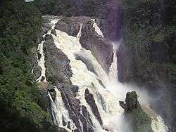
Protected within the Barron Gorge National Park, the volume of water seen in the upper photo only occurs after substantial rainfall during the wet season. For much of the rest of the year, little more than a trickle is evident, due in part to the presence of a weir behind the head of the falls that supplies the Barron Gorge Hydroelectric Power Station located downstream in the gorge.
The Barron Falls may be viewed and accessed by road via the Kennedy Highway that crosses the Barron River upstream of the falls, near Kuranda. The narrow-gauge Kuranda Scenic Railway and the Skyrail aerial tram also leads from the coastal plain to the tablelands. The train stops at Barron Falls overlook, where passengers may disembark for several minutes. The Skyrail stops at two rainforest mid-stations, Red Peak and Barron Falls. The trail at Barron Falls Skyrail station leads through the rainforest to three separate lookouts providing views of the Gorge and Falls.[5]
Etymology
The falls were named for Thomas Henry Bowman Barron, the Chief Clerk of Police in Brisbane in the 1860s.[3]
Tourist attraction
The falls were one of the most popular tourist attractions in Queensland by the 1890s. Visitors are drawn to the natural features and scenery.[4]
See also
References
- ↑ "Barron Falls (QLD)". Gazetteer of Australia online. Geoscience Australia, Australian Government.
- ↑ "Barron Falls (QLD)". Gazetteer of Australia online. Geoscience Australia, Australian Government.
- 1 2 3 4 5 "Barron Falls". World Waterfall Database. 2014. Retrieved 18 May 2014.
- 1 2 Julie Carmody & Bruce Prideaux. "Sustainable Nature Based Tourism: Planning and Management. Report on Visitation and Use at Barron Falls, Far North Queensland 2009/10" (PDF). Wet Tropics Site Report 5/10. Reef and Rainforest Research Centre Limited, Cairns. Retrieved 9 September 2015.
- ↑ "Barron Falls Station". Skyrail Rainforest Cableway. Archived from the original on 5 July 2008.
External links
![]() Media related to Barron Falls at Wikimedia Commons
Media related to Barron Falls at Wikimedia Commons
- "Barron Falls". World of Waterfalls. Johnny T. Cheng. 21 May 2008.