Wallaman Falls
| Wallaman Falls | |
|---|---|
|
Wallaman Falls in Girringun National Park | |
 | |
| Location | North Queensland, Australia |
| Coordinates | 18°35′32″S 145°48′05″E / 18.59222°S 145.80139°ECoordinates: 18°35′32″S 145°48′05″E / 18.59222°S 145.80139°E[1][2] |
| Type | Cascade, horsetail |
| Elevation | 533–554 m (1,749–1,818 ft)[3][4] |
| Total height | 305 m (1,001 ft)[5] |
| Number of drops | 2 |
| Longest drop | 268 m (879 ft)[3][5][6] |
| Total width | 15 m (49 ft)[3] |
| Watercourse | Stony Creek |
| Average flow rate | 3 m3/s (110 cu ft/s)[3] |
| World height ranking | 294[5] |
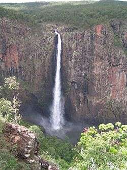
The Wallaman Falls, a cascade and horsetail waterfall on the Stony Creek, is located in the UNESCO World Heritage–listed Wet Tropics in the northern region of Queensland, Australia. The waterfall is notable for its main drop of 268 metres (879 ft),[3][6] which makes it the country's tallest single-drop waterfall.[7] The pool at the bottom of the waterfall is 20 metres (66 ft) deep.[8] An estimated 100,000 people visit the waterfall annually.[7]
Location and features
The waterfall is situated in the Girringun National Park as it descends from the Atherton Tableland, where the Stony Creek, a tributary of the Herbert River, flows over an escarpment in the Seaview Range.[7] The falls initially descend over a small number of cascades before the 268-metre (879 ft) horsetail drop. In total, the falls descend over 305 metres (1,001 ft).[5] Based on the falls' single-drop descent, the World Waterfall Database places Wallaman Falls at 294 in its world rankings.[5]
The geological history of the formation may be traced back some 50 million years, when the uplift of the continental margin in the region created modern landforms. The Herbert River, which previously flowed west, began to cut through the terrain en route to its outflow in the Coral Sea. The gorge produced by this erosive action gradually retreated inland along the Herbert River's course at a rate of 40 centimetres (16 in) per hundred years. The river's tributaries were eventually left suspended by this action, forming their own gorges.[9]
See also
References
- ↑ "Wallaman Falls (QLD)". Gazetteer of Australia online. Geoscience Australia, Australian Government.
- ↑ "Wallaman Falls (entry 36308)". Queensland Place Names. Queensland Government. Retrieved 13 September 2015.
- 1 2 3 4 5 "Wallaman Falls". World Waterfall Database. 21 May 2011. Retrieved 1 December 2013.
- ↑ "Map of Wallaman Falls, QLD". Bonzle Digital Atlas of Australia. Retrieved 30 May 2014.
- 1 2 3 4 5 "Significant Waterfalls". Geoscience Australia. Australian Government. 23 November 2010. Retrieved 30 May 2014.
- 1 2 "Tallest waterfalls in Australia". Geoscience Australia (Press release). Australian Government. 3 July 2002. Retrieved 30 May 2014.
- 1 2 3 Lloyd, Graham (6 April 2013). "Wild Australia: Legends of the Wallaman falls". The Australian. Retrieved 1 December 2013.
- ↑ "Around Townsville National Parks & Reserves". Foundation for National Parks and Wildlife. Retrieved 30 November 2013.
- ↑ "Wallaman Falls, Girringun National Park: Nature, culture and history". Queensland Government. Retrieved 1 December 2013.
External links
![]() Media related to Wallaman Falls at Wikimedia Commons
Media related to Wallaman Falls at Wikimedia Commons
- Wallaman Falls website by the Queensland Government
- Wallaman Falls at the World Waterfall Database
- Girringun National Park - Wallaman Falls (April 2013) on YouTube