Bath (village), New York
| Bath | |
|---|---|
| Village | |
 Bath Location within the state of New York | |
| Coordinates: 42°20′16″N 77°19′1″W / 42.33778°N 77.31694°WCoordinates: 42°20′16″N 77°19′1″W / 42.33778°N 77.31694°W | |
| Country | United States |
| State | New York |
| County | Steuben |
| Area | |
| • Total | 2.9 sq mi (7.5 km2) |
| • Land | 2.9 sq mi (7.5 km2) |
| • Water | 0.0 sq mi (0.0 km2) |
| Elevation | 1,109 ft (338 m) |
| Population (2000) | |
| • Total | 5,641 |
| • Density | 1,959.9/sq mi (756.7/km2) |
| Time zone | Eastern (EST) (UTC-5) |
| • Summer (DST) | EDT (UTC-4) |
| ZIP code | 14810 |
| Area code(s) | 607 |
| FIPS code | 36-04759 |
| GNIS feature ID | 0943162 |
Bath is a village in Steuben County, New York, United States. The population was 5,641 at the 2000 census. Bath is the county seat of Steuben County. The community was named either for the English city of Bath, Somerset, or for Lady Laura Pulteney, 1st Countess of Bath and daughter of Sir William Pulteney, one of the original landowners.
The Village of Bath is in the Town of Bath and is northwest of Elmira, New York and is west of Tyrone, New York.
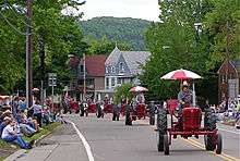
Bath is the location of the Bath VA Medical Center (former old soldiers' home), Bath National Cemetery, and the Steuben County Fair, the oldest continuous fair in the United States.
History
The village was founded in 1793. The village was originally incorporated in 1816, but was not organized until 1836.
In addition to the Bath VA Medical Center, the James H. Bolton House, Campbell-Rumsey House, Cobblestone House, Davenport Library, Erie Freighthouse Historic District, The First Baptist Society of Bath, Gansevoort/East Steuben Streets Historic District, George W. Hallock House, Haverling Farm House, Liberty Street Historic District, McMaster House, Henry C. Myrtle House, Potter-Van Camp House, Martin A. Quick House, Reuben Robie House, Sedgwick House, William Shepherd House, United States Post Office, and M. J. Ward Feed Mill Complex are listed on the National Register of Historic Places.[1][2][3]
Carl Carmer's novel "Genesee Fever," treating of the first white settlements in the region, is set largely in Bath. Bath was the site of the land office disposing of 1.2 million acres. [4]
Geography
Bath is located at 42°20′15″N 77°19′0″W / 42.33750°N 77.31667°W (42.33765, -77.316876).[5]
According to the United States Census Bureau, the village has a total area of 2.9 square miles (7.5 km²).None of the area is covered with water.
The village is adjacent to Interstate 86, a few miles east of the split with Interstate 390. New York State Route 54 intersects New York State Route 415 in the village. County Roads 10 and 13 also lead into Bath.
Bath is served by the Bath & Hammondsport Railroad which operates over former Delaware, Lackawanna & Western (DL&W) mainline trackage between a connection with Norfolk Southern in Painted Post, and the company's terminus in Cohocton. (Trackage to Wayland remains in place but is no longer used. Service on the original B&H between Bath and Hammondsport has also been discontinued.)
The Erie Railroad's Rochester Division once passed through Bath. The 1960 merger of the Erie and DL&W led to the creation of Erie-Lackawanna which was followed by the elimination of redundant trackage. The Erie line through Bath was abandoned, as was much of the DL&W west of Wayland. The result was a drastic reduction of railroad activity in Bath since traffic could be routed over the parallel ex-Erie mainline through the Canisteo River Valley.
Erie-Lackawanna was absorbed into the Consolidated Rail Corporation (Conrail) in 1976. In 1999, Conrail lines in the region were acquired by Norfolk Southern. Since then, the Bath & Hammondsport has become a subsidiary of the Livonia, Avon & Lakeville which currently operates the line, though not over any of its original route. Trains operate through Bath five days per week.
The Conhocton River flows through Bath, and Lake Salubria is a small lake southeast of the village.
Demographics
| Historical population | |||
|---|---|---|---|
| Census | Pop. | %± | |
| 1810 | 453 | — | |
| 1830 | 1,000 | — | |
| 1840 | 1,400 | 40.0% | |
| 1850 | 2,500 | 78.6% | |
| 1860 | 2,012 | −19.5% | |
| 1870 | 1,465 | −27.2% | |
| 1880 | 3,183 | 117.3% | |
| 1890 | 3,261 | 2.5% | |
| 1900 | 4,994 | 53.1% | |
| 1910 | 3,884 | −22.2% | |
| 1920 | 3,720 | −4.2% | |
| 1930 | 4,015 | 7.9% | |
| 1940 | 4,696 | 17.0% | |
| 1950 | 5,416 | 15.3% | |
| 1960 | 6,166 | 13.8% | |
| 1970 | 6,053 | −1.8% | |
| 1980 | 6,042 | −0.2% | |
| 1990 | 5,801 | −4.0% | |
| 2000 | 5,641 | −2.8% | |
| 2010 | 5,786 | 2.6% | |
| Est. 2015 | 5,635 | [6] | −2.6% |
As of the census[8] of 2000, there were 5,641 people, 2,612 households, and 1,400 families residing in the village. The population density was 1,959.9 people per square mile (756.3/km²). There were 2,826 housing units at an average density of 981.9 per square mile (378.9/km²). The racial makeup of the village was 96.19% White, 1.38% Black or African American, 0.32% Native American, 0.89% Asian, 0.02% Pacific Islander, 0.12% from other races, and 1.08% from two or more races. Hispanic or Latino of any race were 0.90% of the population.
There were 2,612 households out of which 24.0% had children under the age of 18 living with them, 38.2% were married couples living together, 12.1% had a female householder with no husband present, and 46.4% were non-families. 40.0% of all households were made up of individuals and 20.5% had someone living alone who was 65 years of age or older. The average household size was 2.14 and the average family size was 2.85.
In the village the population was spread out with 21.9% under the age of 18, 8.0% from 18 to 24, 25.0% from 25 to 44, 24.6% from 45 to 64, and 20.5% who were 65 years of age or older. The median age was 42 years. For every 100 females there were 91.7 males. For every 100 females age 18 and over, there were 87.8 males.
The median income for a household in the village was $28,897, and the median income for a family was $39,114. Males had a median income of $31,685 versus $25,087 for females. The per capita income for the village was $18,337. About 10.8% of families and 15.5% of the population were below the poverty line, including 16.6% of those under age 18 and 8.5% of those age 65 or over.
Notable people
- Frank Bowes, former professional baseball player
- Ira Davenport, former US Congressman
- George Grueb (1835-1893), Medal of Honor recipient in the American Civil War, was buried in Bath.[9]
- Edward Howell, former US Congressman
- Frank Fernando Jones, former Iowa legislator and businessman
- John Magee, former US Congressman
- Reuben Robie, former US Congressman
- David Rumsey, former US Congressman
- Edwin S. Underhill, former US Congressman
- William Woods, former US Congressman
References
- ↑ National Park Service (2010-07-09). "National Register Information System". National Register of Historic Places. National Park Service.
- ↑ "National Register of Historic Places Listings". Weekly List of Actions Taken on Properties: 1/22/13 through 1/25/13. National Park Service. 2013-06-21.
- ↑ "National Register of Historic Places Listings". Weekly List of Actions Taken on Properties: 2/23/15 through 2/27/15. National Park Service. 2015-03-06.
- ↑ Carmer, Carl. Genesee Fever, Farrer & Rinehart, 1941.
- ↑ "US Gazetteer files: 2010, 2000, and 1990". United States Census Bureau. 2011-02-12. Retrieved 2011-04-23.
- ↑ "Annual Estimates of the Resident Population for Incorporated Places: April 1, 2010 to July 1, 2015". Retrieved July 2, 2016.
- ↑ "Census of Population and Housing". Census.gov. Archived from the original on May 11, 2015. Retrieved June 4, 2015.
- ↑ "American FactFinder". United States Census Bureau. Archived from the original on 2013-09-11. Retrieved 2008-01-31.
- ↑ "George Grueb". Retrieved July 19, 2014.
External links
| Wikimedia Commons has media related to Bath (village), New York. |
- Brief information about Bath, NY
- Bath Branch National Home for Disabled Volunteer Soldiers (National Park Service)
- Bath National Cemetery
- Bath VA Medical Center
- Bath & Hammondsport Railroad
Municipalities and communities of Steuben County, New York, United States | ||
|---|---|---|
| Cities | 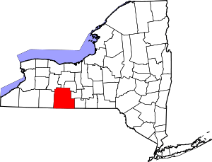 | |
| Towns | ||
| Villages | ||
| CDPs |
| |
| Hamlets | ||
| Footnotes | ‡This populated place also has portions in an adjacent county or counties | |