Heanor
| Heanor | |
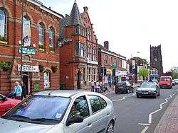 Heanor Town Hall (left), with St Lawrence's Church (right) |
|
 Heanor |
|
| Population | 17,251 |
|---|---|
| OS grid reference | SK433465 |
| Civil parish | Heanor and Loscoe |
| District | Amber Valley |
| Shire county | Derbyshire |
| Region | East Midlands |
| Country | England |
| Sovereign state | United Kingdom |
| Post town | HEANOR |
| Postcode district | DE75 |
| Dialling code | 01773 |
| Police | Derbyshire |
| Fire | Derbyshire |
| Ambulance | East Midlands |
| EU Parliament | East Midlands |
| UK Parliament | Amber Valley |
|
|
Coordinates: 53°00′49″N 1°21′12″W / 53.0137°N 1.3534°W
Heanor (pronunciation: /ˈhiːnə/) is a town in the Amber Valley district of Derbyshire in the East Midlands of England. It lies 8 miles (13 km) north-east of Derby. Together with the adjacent village of Loscoe it forms the civil parish and town council-administered area of Heanor and Loscoe, which in the 2011 census had a population of 17,251.
History
The name Heanor derives from the Old English hēan (the dative form of hēah) and ofer, and means '(place at) the high ridge'. In the Domesday Book of 1086 it was recorded as Hainoure,[1] with its entry stating:
6M In CODNOR and Heanor and Langley [in Heanor] and 'Smithycote' [in Codnor Park] 8 thegns had 7 carucates of land to the geld [before 1066]. [There is] land for as many ploughs. There are now 3 ploughs in demesne; and 11 villans and 2 bordars and 3 sokemen having 5½ ploughs. There is a church, and 1 mill [rendering]12d , and 35 acres (140,000 m2) of meadow, [and] woodland pasture 2 leagues long and 3 furlongs broad. TRE[2] worth £4 sterling; now 41s 4d [£2.2] per year. Warner holds it.[3]
Samuel Lewis's A Topographical Dictionary of England, published in 1848, stated that Heanor parish "abounds with coal and ironstone, both worked extensively, the collieries alone affording employment to more than 2000 persons. The town is pleasantly situated upon an eminence, on the road from Derby to Mansfield. The principal articles of manufacture are silk and cotton goods, hosiery, and bobbinet lace, providing occupation to about 800 persons." The parish at that time covered 7,000 acres (2,800 ha) and was in the union of Basford and the hundred of Morleston and Litchurch, with Heanor town itself covering 1,500 acres (610 ha) and containing 3,058 inhabitants. The parish church was described as being dedicated to St Mary and was "a very ancient edifice, with a lofty substantial tower, from which is an extensive view", though the dictionary noted that there were also "places of worship for Baptists, Independents, Wesleyans, and Ranters".[4]
Heanor Market Place was developed in the 1890s, following the break-up of the Heanor Hall estate by the Miller Mundy family of nearby Shipley Hall (the Market Place site had been part of Heanor Hall Park). Until this development the main focus of market trading activity had been at Tag Hill.[5]
Governance
Civic history
The parish of Heanor formed a local board in about 1850 to provide services in the town. In 1895, under the Local Government Act 1894, the board's area became an urban district. In 1899 Heanor Urban District was enlarged with the addition of the neighbouring parish of Codnor and Loscoe.[6][7] The urban district continued in existence until 1974, when it became part of the new non-metropolitan district of Amber Valley under the Local Government Act 1972.[8] Heanor Urban District had been an unparished area,[8] but in 1984 three new civil parishes were created within Amber Valley, with Heanor placed within the civil parish of Heanor and Loscoe (the other 2 parishes being Aldercar and Langley Mill and Codnor). In 1987 Heanor and Loscoe Parish Council resolved to designate the parish a town,[n 1] so Heanor and Loscoe is governed by a town council, headed by a town mayor.
Current
Since 1984 Heanor has had three tiers of local government: Derbyshire County Council at the county level (the top tier), Amber Valley Borough Council at the district level (the middle tier), and Heanor and Loscoe Town Council at the parish level (the bottom tier). Heanor falls into two single-member electoral divisions of the County Council, Greater Heanor and Heanor Central. Following the elections of 2013, both divisions are represented by members of the Labour Party.[9] For representation within Amber Valley Borough Council, Heanor and Loscoe civil parish is divided into three electoral wards (Heanor East, Heanor West, and Heanor and Loscoe) that each elect two councillors; as of 2014 all six councillors were from the Labour Party.[10]
Geography
Measured directly, Heanor town is 8 miles (13 km) northeast of Derby and 9.5 miles (15.3 km) westnorthwest of Nottingham.[11][12] It is sited on a hill between about 65 metres (213 ft) and 125 metres (410 ft) above sea-level.[13] It is within the Nottinghamshire, Derbyshire and Yorkshire Coalfield National Character Area, as defined by Natural England.[14]
Heanor and Loscoe civil parish includes all of Heanor town except Heanor Gate Science College and a few surrounding streets on the western edge of town (near the road to Smalley), Heanor Gate Industrial Estate to the south west, and a small area of houses on the town's southeasterly fringe, near the main road to Ilkeston. The college and surrounding streets, plus half the industrial estate, are within Smalley civil parish; the other areas are within the civil parish of Shipley.[13]

Heanor and Loscoe civil parish contains no conservation areas, though 30% of the area is within a green belt, and there is one nature reserve and four wildlife sites, all of local significance.[15]
Economy
The most important economic sector in the town, employing more than 20% of the working population, is manufacturing, with the retail sector almost as significant, employing over 17%. Coal mining and textiles used to be the major industries of the town, but both of these have declined. In December 2013 the unemployment rate was 2.3% in Heanor East and Heanor and Loscoe wards, and 3.5% in Heanor West ward. The average for England at this time was 2.8%.[15]
The Matthew Walker factory, famous for the production of Christmas puddings and situated on Heanor Gate Industrial Park, was sold in 1992 to become part of the Northern Foods Group. Other companies on the park include Advanced Composites Group, Cullum Detuners Ltd and Isolated Systems Ltd. In 2011 the 2 Sisters Food Group purchased Northern Foods. The Matthew Walker factory is now a part of the 2 Sisters Chilled Division.
Major retail chains with a presence in the town include Tesco,[15] Aldi,[16] Argos[17] and Brantano.[18] A small outdoor market takes place in the town every Friday and Saturday.[19]
Heanor merges into Langley Mill and is served by Langley Mill railway station.
Demography
In the 2011 census Heanor and Loscoe civil parish had 7,512 dwellings,[20] 7,221 households and a population of 17,251.[21] 18.7% of residents were under the age of 16 (compared to 18.9% for England as a whole) and 16.5% of residents were aged 65 or over (compared to 16.4% for England as a whole).[22] Similar to the rest of Amber Valley district, the population was ethnically less diverse than the average for England; 1.84% of residents were of non-white ethnicity, compared to 14.58% for England as a whole.[23] Christianity was the most prevalent stated religion (56.4% of all residents, compared to 59.4% for England as a whole). 35.6% of residents stated that they had no religion (compared to 24.7% for England as a whole).[24]
Education
Heanor contains two infant schools (Corfield Church of England Infant School and Marlpool Infant School), three primary schools (Coppice Primary School, Howitt Primary Community School and Loscoe Church of England Primary School), two junior schools (Marlpool Junior School and Mundy Church of England Voluntary Controlled Junior School) and two secondary schools (Heanor Community College and Heanor Gate Science College).[15] Heanor Grammar School, which was just to the east of the market place, is now part of Derby College (formerly South East Derbyshire College). A book on the history of the school was published in 2008.[25]
Sport and leisure

Shipley Country Park borders the south and west of the town. This steep wooded knoll with its own riding school and three lakes surrounding it consists of most of the former estate of the Miller-Mundy family who lived at Shipley Hall (demolished in the 1940s) until the 1920s. It was sold for coal mining purposes and was intensively opencast and deep seam mined by what became the National Coal Board before being restored and handed over to the county council in the 1970s.
The local football team is known as 'The Lions' – Heanor Town Football Club. Established in 1883, the club is a member of the Northern Counties East League Premier Division. It also has a youth team called Heanor Juniors. Famous ex-players include Nigel Clough, who went on to play for Nottingham Forest}, Liverpool and Manchester City. He is now the manager of Burton Albion;[26] and Nigel Pearson, who after leaving Heanor captained Sheffield Wednesday to a League Cup win over Manchester United at Wembley, is formerly the manager at Leicester City.
The Lions share grounds with Heanor Town Cricket Club.
Heanor Clarion Cycling Club was founded in 1934.[27]
Transport
The nearest station is at Langley Mill two miles away, which has services to Nottingham, Sheffield and beyond. Formerly the Midland Railway had a line between Shipley Gate and Butterley that passed through Heanor (closed to passengers in 1926), and the Great Northern Railway had a branch line which terminated in a goods yard and small station in Heanor (closed in 1928, though temporarily revived in 1939).
Bus routes link Heanor with larger towns in the area such as Nottingham, Derby and Mansfield. Major bus operators serving Heanor include Trent Barton, Yourbus and Midland General.
Media
The local newspaper which serves, amongst others, the communities of Ripley, Heanor, Marlpool, Loscoe, Waingroves, Aldercar, Crosshill and Codnor is the 'Ripley and Heanor News'. However, its circulation area is not limited to these towns and villages and could be considered to extend from Whatstandwell in the west, to Brinsley in the east; from South Normanton in the north, to Coxbench in the south. It is published each Thursday.
Notable residents
- Billy Bestwick (1875–1938), cricketer, born in Heanor.
- George William Bissill (1896–1973), painter, grew up in Langley Mill and attended school in Heanor.[28]
- Sir Richard William Barnes Clarke (1910–1975), journalist and civil servant, born in Heanor.[29]
- Henry Garnet (1555–1606), Jesuit, executed for involvement in the Gunpowder Plot, born in Heanor.
- William Gregg (1890–1969), awarded the Victoria Cross for bravery in 1918,[30] born and died in Heanor.
- The Howitt brothers: William Howitt (1792–1879), author,[31] Richard, poet (1799–1869) and Godfrey, entomologist, (1800–1873), born in Heanor.
- Mary Howitt (1799–1888), author, lived in Heanor.
- Douglas Keen (27 October 1913 – 6 November 2008), designer of Ladybird Books, lived in Heanor and created the first title in the kitchen of a house in Heanor.[32][33]
- Samuel Roper (died 1658), antiquary, born in Heanor.[34]
- Edward Smith (1819–1874), physician, medical writer and dietician, born in Heanor.[35]
- John Varley (1740–1809), canal engineer, supervised construction of the Chesterfield Canal, born in Heanor.
- Samuel Watson (c. 1662–1715), sculptor, born in Heanor.[36]
Notable buildings
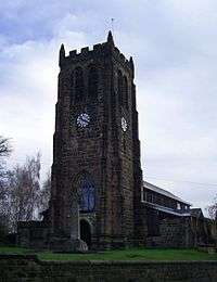
Ten structures in Heanor and Loscoe civil parish are listed by Historic England as of particular architectural or historical interest. Two are in Loscoe and eight in Heanor. None is listed as Grade I, but the Church of St Lawrence in Heanor is listed as Grade II*. The other nine structures are all listed as Grade II.[37] St Lawrence's has 15th-century origins, although it was altered in 1866–68 and again about 1980.[38]
Notes and references
- Notes
- ↑ Under section 245 of the 1972 Act
- References
- ↑ David Mills, ed. (2011) [1991]. A Dictionary of British Place Names. Oxford University Press. ISBN 0-19-852758-6.
- ↑ TRE in Latin is Tempore Regis Edwardi. This means in the time of King Edward before the Battle of Hastings.
- ↑ Domesday Map Retrieved 2013-07-16
- ↑ Samuel Lewis, ed. (1848). A Topographical Dictionary of England. British History Online. pp. 456–459. Retrieved 9 April 2016.
- ↑ "Heanor Market Place". Heanor & District Local History Society. Retrieved 18 April 2016.
- ↑ "Heanor". Kelly's Directory of Derbyshire. Historical Directories. 1912. p. 296. Retrieved 1 June 2010.
- ↑ Youngs, Frederic A, Jr. (1991). Guide to the Local Administrative Units of England, Vol.2: Northern England. London: Royal Historical Society. p. 77. ISBN 0-86193-127-0.
- 1 2 Local government in England and Wales: A Guide to the New System. London: HMSO. 1974. p. 40. ISBN 0-11-750847-0.
- ↑ "Councillors". Derbyshire County Council. Retrieved 16 June 2010.
- ↑ "Borough Councillors: Lookup". Amber Valley Borough Council. Archived from the original on 13 April 2010. Retrieved 24 May 2014.
- ↑ Ordnance Survey (2001), 1:50,000 Landranger Series, Sheet 128 (Derby & Burton upon Trent), ISBN 0-319-22540-2
- ↑ Ordnance Survey (1996), 1:50,000 Landranger Series, Sheet 129 (Nottingham & Loughborough area), ISBN 0-319-22129-6
- 1 2 Ordnance Survey (2000), 1:25,000 Explorer Series, Sheet 260 (Nottingham, Vale of Belvoir), ISBN 0-319-21896-1
- ↑ "NCA Profile: 38. Nottinghamshire, Derbyshire and Yorkshire Coalfield (NE402)". Natural England. 31 January 2013. Retrieved 11 April 2016.
- 1 2 3 4 "Area Profile: Heanor". Amber Valley Borough Council. Retrieved 14 April 2016.
- ↑ "ALDI - High Street". Aldi Stores Limited. Retrieved 17 April 2016.
- ↑ "Welcome to the Argos store at Heanor". Argos Limited. Retrieved 17 April 2016.
- ↑ "Brantano Heanor Retail Park". Brantano Retail Limited. Retrieved 17 April 2016.
- ↑ "Heanor - Up and Coming Market Town - Love Heanor". visitambervalley.com. Amber Valley Borough Council. 2012. Retrieved 12 April 2016.
- ↑ "Area: Heanor and Loscoe (Parish). Dwellings, Household Spaces and Accommodation Type, 2011 (KS401EW)". Neighbourhood Statistics. Office for National Statistics. Retrieved 6 April 2016.
- ↑ "Area: Heanor and Loscoe (Parish). Key Figures for 2011 Census: Key Statistics". Neighbourhood Statistics. Office for National Statistics. Retrieved 6 April 2016.
- ↑ "Area: Heanor and Loscoe (Parish). Age Structure, 2011 (KS102EW)". Neighbourhood Statistics. Office for National Statistics. Retrieved 6 April 2016.
- ↑ "Area: Heanor and Loscoe (Parish). Ethnic Group, 2011 (KS201EW)". Neighbourhood Statistics. Office for National Statistics. 30 January 2013. Retrieved 14 April 2016.
- ↑ "Area: Heanor and Loscoe (Parish). Religion, 2011 (KS209EW)". Neighbourhood Statistics. Office for National Statistics. 30 January 2013. Retrieved 17 April 2016.
- ↑ Follow the Master. Heanorhistory.org.uk. Retrieved on 5 May 2013.
- ↑ Clough takes over as Derby boss, BBC Sport, 6 January 2009.
- ↑ Heanor Clarion Cycling Club Retrieved June 2007
- ↑ Seddon, Peter (20 October 2015). "George Bissill - Derbyshire's forgotten 'Pitman Painter'". Derbyshire Life Magazine. Archant Community Media Ltd. Retrieved 17 April 2016.
- ↑ Goldman, Samuel (September 2004). "Clarke, Sir Richard William Barnes (1910–1975)". Oxford Dictionary of National Biography. Oxford: Oxford University Press. doi:10.1093/ref:odnb/30938. Retrieved 4 June 2010.
- ↑ GRAVE LOCATION FOR HOLDERS OF THE VICTORIA CROSS IN THE COUNTY OF : DERBYSHIRE. Victoriacross.org.uk. Retrieved on 5 May 2013.
- ↑ William Howitt. The Notable Names Database (NNDB).
- ↑ Connolly, Cressida (29 November 2008) Obituary: Douglas Keen, The Guardian.
- ↑ Hawley, Zena (14 January 2013) How Douglas's little Ladybird books had a big impact on our education. This is Derbyshire. Retrieved on 5 May 2013.
- ↑ British History academic site accessed 7 October 2007
- ↑ Carpenter, Kenneth J (September 2004). "Smith, Edward (1819–1874)". Oxford Dictionary of National Biography. Oxford: Oxford University Press. doi:10.1093/ref:odnb/25794. Retrieved 4 June 2010.
- ↑ Brighton, Trevor (September 2004). "Watson, Samuel (bap. 1662, d. 1715)". Oxford Dictionary of National Biography. Oxford: Oxford University Press. doi:10.1093/ref:odnb/28864. Retrieved 4 June 2010.
- ↑ "Listed Buildings in Heanor and Loscoe, Derbyshire, England". britishlistedbuildings.co.uk. Retrieved 4 April 2016.
- ↑ "Church of St Lawrence, Heanor and Loscoe". britishlistedbuildings.co.uk. Retrieved 10 April 2016.
External links
| Wikimedia Commons has media related to Heanor. |
- The Heanor Town Directory
- Heanor and District Local History Society
- Ripley and Heanor News
- Heanor Gate Science College
- Heanor Festival Week
- Heanor news from the Derby Telegraph
- Langley Mill heritage Group
- Visit Amber Valley
- Public transport links from Heanor
| Unitary authorities | |
|---|---|
| Boroughs or districts | |
| Major settlements |
|
| Rivers | |
| Topics | |