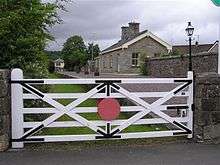
Belcoo
| Belcoo | |
| Irish: Béal Cú | |
 |
|
 Belcoo |
|
| Population | 486 (2001 Census) |
|---|---|
| District | Fermanagh and Omagh |
| County | County Fermanagh |
| Country | Northern Ireland |
| Sovereign state | United Kingdom |
| Post town | ENNISKILLEN |
| Postcode district | BT93 |
| Dialling code | 028 |
| EU Parliament | Northern Ireland |
| UK Parliament | Fermanagh and South Tyrone |
| NI Assembly | Fermanagh and South Tyrone |
|
|
Coordinates: 54°17′46″N 7°52′16″W / 54.296°N 7.871°W
Belcoo pronounced: [bɛlˈkʉː] (from Irish: Béal Cú, meaning "mouth of the narrow [stretch of water]")[1][2] is a small village and townland in County Fermanagh, Northern Ireland, 10 miles from Enniskillen. It is on the County Fermanagh/County Cavan border beside the village of Blacklion in the Republic of Ireland. It had a population (with Holywell) of 486 in the 2001 Census. It is situated within Fermanagh and Omagh district.
The Lough MacNean Tourism Initiative has been in operation since 2003, and is an economy building project, aimed at addressing tourism needs in the area while promoting cross-border relations. Belcoo Enterprise Ltd opened in 1992 in units shared with the Belcoo Historical Society, a doctor's surgery, a chiropodist and Lakeland Community Care. The Mullycovet corn mill, which functioned from 1830 until the 1920s, is being restored. The Indigenous Resources School of Transferable Skills aims to teach marginalised groups including the unemployed, New Age travellers, the disabled, to use natural materials as a learning facility.
History
The earliest mention of the village is in the old Ulster Saga "Argain Belcon Breifne" also known as "Togail Bruidne Bélchon Bréifne" (Massacre of Belcu Brefne). This tells the tale of a trap set for the great Ulster hero Conall Cernach by a Breifne chief named Belcu Brefne. However Conall manages to reverse the trap and causes Belcu's sons to kill Belcu by mistake. The place where the tale occurs was later named Belcu or sometimes Belcon in honour of Belcu. Isaac Butler in his book "A Journey to Lough Derg" written in c. 1749 states-
At Bell Con in this Neighbourhood on the road to Sligo is a famous Well called Davagh Patrick, or the holy Well it is found by repeated Experience to be the best Cold Bath in the Kingdom, having releived Numbers in nervous & paralitic Disorders, & is coming into great request, it is exceeding transparent & so intensly cold the that it throws one into a shaking Fit by putting one's hand into it, it exhibits a Stream that turns 2 mills at 150 Yards from the Spring.36 In April & May succeeding the great Frost in 1740 happened an Accident that gave Birth to a Miracle at this Spring but they could not ascribe the Saint without it was St. Patrick; the water was changed into the Color of Milk & as it was of a fine solf nature it quickly gaind the repute of being milk by the Vulgar who flockt from all parts to see it they could not be convinced to the Contrary until it ceased, it continued 7 Weeks. Father O Mulloy thus accounted for it, that the ajacent lands were full of marly bottoms, that this Spring having it's Channel thro those beds of Marl, upon the breaking of the Frost, the marl was loosened & fell into the Spring and gave it the tincture which subsiding it returned to it's usual Transparency & then the Wonder ceased.[3] [4]
A modern interpretation however states that the name of the village derives from the Irish: béal meaning mouth and cumhang or cung meaning narrowing, referring to the village's position on a narrow neck of water (river) between Upper and Lower Lough MacNean. This interpretation is given support, firstly in the 14th century Book of Magauran where it is mentioned several times as Cunga,[5] secondly in an Inquisition held at Dromahair on 22 July 1607 which described the boundaries of County Leitrim inter alia as- and so to Beallacowngamore, and then to Beallucowngabegg, and thirdly by the name of the place on the 1609 Ulster Plantation map where it is named 'Kiliconge', i.e. Coille Cunga meaning "The Wood of the Narrow Strip of Land".[6] The townland to the immediate north of Belcoo continues this interpretation as it is called Drumcoo, i.e. The Hill of the Narrow Strip of Land. Another often used derivation is Béal Cú i.e. where Cú is the word for hound. Hence the village name would mean "The Mouth of the Hound". Máire MacNeill in her book "The Festival of Lughnasa", 1962, gives a local Belcoo folktale about balefire coming out of a hound's mouth before it is killed by Saint Patrick.[7]
In the Irish Rebellion of 1641, the English Army erected a fort at Belcoo which can be seen on the Down Survey maps of 1655. When the Irish surrendered at Cavan on 27 April 1653, paragraph 7 of the Articles of Surrender stated-"That Collonel Reily with the partie now with him on the west side of Loughern lay downe their armes, and deliver such forts in the islands, with all the amunicion and provision therein that is in his powre, at or before the 18 of May next, at Crohan, and Collonel Hugh Me Guier's regiment to lay downe their armes the 18 of May next, at 'Belcowe fort', in the county of Fermanagh, and all others of his partie included in these articles are to lay downe their armes in the severall counties where their quarters are, in such places as the Governors of the several counties shall apoynt."[8][9] The fort was still in existence in 1700, as an entry in the Calendar of Treasury Books dated 1 June 1700 states there was "1 foot soldier at Belcoe who receives an allowance of £14 per annum in respect of fire and candle for the Barracks"
In Seamus Pender's "A Census of Ireland, Circa 1659", the village is called "Belcow".
In his book "Upper Lough Erne", written in 1739, Reverend William Henry states, "Lough Macnane ... is contracted into a narrow, deep canal, in which form it flows through a flat meadow for half a mile to the redoubt of Bellcoe, where is a good ford and a new bridge across it. From the ford, the lake, expanding again, continues for three miles more".[10]
Matthew Sleater's Directory of 1806 states "Belcoo-bridge (which leads to Garrison in Fermanagh County) over a river containing the two lakes called Lough Macnean, which extends along this road 6 miles".
About two miles north-east of Belcoo is Gardenhill, an old derelict homestead. It is located on the side of a hill in Gardenhill townland, just off the sideroad from Belcoo to Boho. Parts of this old homestead possibly date from the early years of the Plantation of Ulster in the early seventeenth-century. It was rented, and later owned, by the Hassard family for around 300 years. Gardenhill is privately owned and is not open to the public.
The Troubles
For more information see The Troubles in Belcoo, which includes a list of incidents in Belcoo during the Troubles resulting in two or more fatalities.
Transport
Belcoo is situated on the A4 road from Enniskillen, at the point where it reaches the border with the Republic of Ireland and becomes the N16. Buses on the Enniskillen to Bundoran Ulsterbus Service 64, operated by Translink, stop here.[11]
The village formerly had a small railway station on the railway line serving Sligo and Leitrim and Enniskillen. In 1878 a stationmaster’s house and six houses were built for railway workers and their families and the following year the Sligo, Leitrim and Northern Counties Railway line opened with Belcoo station serving both Belcoo and Blacklion. Belcoo railway station opened on 18 March 1879, and closed on 1 October 1957. The last trains ran through the station on 20 September 1957.[12]
Bus Éireann calls at Belcoo on the service Sligo-Manorhamilton-Enniskillen Expressway route 66.[13] The bus stops at Sligo bus station which is beside Sligo railway station, the nearest operational station, with trains to Dublin Connolly. Irish Rail- Official site
People
- Brendan Dolan (1973), darts player
Notes
- ↑ Flanagan, Deirdre & Laurence; Irish Place Names, page 172. Gill & Macmillan, 2002. ISBN 0-7171-3396-6
- ↑ Placenames NI - Belcoo
- ↑ Butler, Isaac (1892). Cooper, Austin, ed. "A Journey to Lough Derg". Journal of the Royal Society of Antiquaries of Ireland. 5. II: 13–24.
- ↑
- ↑ L. McKenna (1947), The Book of Magauran
- ↑
- ↑ MacNeill, Máire (1962). The festival of Lughnasa: a study of the survival of the Celtic festival of the beginning of harvest. London: Oxford University Press.
- ↑ Gilbert, John T. A Contemporary History of Affairs in Ireland from 1641 to 1652 p374
- ↑ Dunlop, Robert (2008 reprint of 1913). Robert Dunlop, ed. reland Under the Commonwealth. Manchester University Publications - reprinted by BiblioBazaar, LLC,. p. 336. ISBN 978-1-116-08088-9. Check date values in:
|date=(help) - ↑ Henry, Rev. William (1892). King, Sir Charles S, ed. Upper Lough Erne (PDF). Dublin: William McGee. pp. 50–51.
- ↑ "Ulsterbus Service 64 Outbound Timetable". Translink. Retrieved 5 October 2010.
- ↑ "Belcoo station" (PDF). Railscot - Irish Railways. Archived (PDF) from the original on 26 September 2007. Retrieved 12 September 2007.
- ↑ http://buseireann.ie/pdf/1360753125-066.pdf
References
- NI Neighbourhood Information Service
- Culture Northern Ireland
- The death of Belcu
- Belcoo & Blacklion Station
External links
| Wikimedia Commons has media related to Belcoo. |