Cliffs of Magho

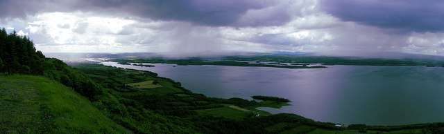
The Cliffs of Magho are a 9-kilometre-long (5.6 mi) limestone escarpment located in the townland of Magho, County Fermanagh, Northern Ireland. The NNW-facing cliffs overlook the western reaches of Lower Lough Erne and define the northern edge of Lough Navar Forest, a major plantation managed by the Forest Service of Northern Ireland. A popular viewpoint atop the cliffs is accessed by a forest drive.
The escarpment is formed from two distinct bands of Carboniferous limestone: the Glencar Limestone Formation and the overlying Dartry Limestone Formation. These overlie a series of mudrocks known as the Benbulben Shale Formation. Under the cliffs lie a mostly continuous apron of scree and landslipped material.
The cliffs are a proposed Area of Special Scientific Interest. They are home to the Irish Rock-bristle (Seligeria oelandica), a black moss found on wet calcareous rocks and known only from this site in the whole of the United Kingdom, though found elsewhere in the Republic of Ireland.[1]
Since 2007 these cliffs have formed a part of the Marble Arch Caves Global Geopark.[2]
References
- ↑ "Magho Cliffs – Summary". Earth Science Conservation Review. National Museums Northern Ireland. Retrieved 4 September 2012. External link in
|work=(help) - ↑ "Geopark News: The Worlds First International Geopark!". Fermanagh District Council. 2008. Retrieved 4 September 2012.