Castle Balfour
| Castle Balfour | |
 Castle Balfour, Lisnaskea, County Fermanagh, Northern Ireland |
|
 Castle Balfour |
|
| Irish grid reference | H3634 |
|---|---|
| District | Fermanagh and Omagh |
| County | County Fermanagh |
| Country | Northern Ireland |
| Sovereign state | United Kingdom |
| Postcode district | BT |
| Dialling code | 028, +44 28 |
| EU Parliament | Northern Ireland |
| UK Parliament | Fermanagh and South Tyrone |
| NI Assembly | Fermanagh and South Tyrone |
|
|
Coordinates: 54°15′08″N 7°26′32″W / 54.2523°N 7.4423°W
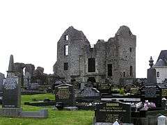
Castle Balfour is a castle situated in Lisnaskea, County Fermanagh, Northern Ireland. It sits at the edge of the parish graveyard just west of Main Street.[1] The castle is a State Care Historic Monument sited in the townland of Castle Balfour Demesne, in the Fermanagh and Omagh district area, at grid ref: H3622 3369.[2]
History
Castle-skeagh was granted to Michael, Lord Balfour by King James I and re-granted to James, Lord Balfour, from Fife, Scotland, in 1620, in the Plantation of Ulster.[3][4] In 1618/19 Captain Nicholas Pynnar reported that Balfour had begun his building at Castle-skeagh.[3] The village of Lisnaskea developed around it. The castle was altered in 1652 and damaged in 1689.[5] The last person to possess and inhabit the Castle was James Haire (1737-1833) who leased the castle from Earl Erne. James Haire and his family ceased to occupy the castle after it was destroyed by an arson-based fire in 1803. His mother, Mrs. Phoebe Haire, was killed by the fire. It is believed that the perpetrator of the fire was a member of the Maguire clan. Major conservation and restoration was undertaken in the 1960s and further conservation work was completed in the late 1990s.[5]
Evidence of an earlier ringfort indicates the area had been inhabited from very early times. In Castle Balfour Demesne, slight surface evidence for a fosse between two banks was revealed after excavation to have been 2m deep. Attempts to find the outer fosse of a bivallate ringfort revealed ‘no distinct, steep edges’ contrasting with the steeply cut inner fosse. Radiocarbon dates of 359-428 AD were found from the ringfort at Castle Balfour.[6]
Features
In 1618/19 Captain Nicholas Pynnar reported that Balfour had 'laid the foundation of a bawne of lime and stone 70 ft square, of which the two sides are raised 15 ft high. There is also a castle of the same length, of which the one half is built two stories high and is to be three stories and a half high’. Castle Balfour was a long, rectangular three storey building, on a north-south axis, the main block being 26m by 8m.[3] It had a square wing to the east and west and a later rectangular block on the northern end.[7] It has the style of a Scottish castle and the building is thought to be the work of Lowland Scots masons.[8] The surviving castle is in a T plan with an entrance with gun-loops. The castle has vaulted rooms and a kitchen with fireplace and oven on the ground floor, main dwelling rooms on the first floor and corbelled turrets with gun slits.[4][5]
See also
References
- ↑ Department of the Environment NI (1987). Historic Monuments of Northern Ireland. Belfast: HMSO. p. 119.
- ↑ "Castle Balfour" (PDF). Environment and Heritage Service NI - State Care Historic Monuments. Retrieved 2007-12-03.
- 1 2 3 Flanagan, Laurence (1992). A Dictionary of Irish Archaeology. Dublin: Gill and Macmillan. pp. 50–51.
- 1 2 Sandford, Ernest (1976). Discover Northern Ireland. Belfast: Northern Ireland Tourist Board. p. 152. ISBN 0 9500222 7 6.
- 1 2 3 "Castle Balfour" (PDF). Northern Ireland Environment Agency. Retrieved 18 April 2015.
- ↑ Stout, Matthew (1997). The Irish Ringfort. Dublin: Four Courts Press. pp. 18 and 28.
- ↑ Fry, Plantagenet Somerset (2001). Castles of Britain and Ireland. Newton Abbot: David and Charles. p. 204.
- ↑ "Other Plantation Castles in Fermanagh" (PDF). The Plantation of Ulster: The Story of Co Fermanagh. Retrieved 18 April 2015.
| Wikimedia Commons has media related to Castle Balfour. |