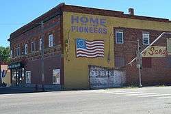
Big Sandy, Montana
| Big Sandy, Montana | |
|---|---|
| Town | |
 | |
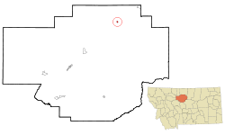 Location of BigSandy, Montana | |
| Coordinates: 48°10′40″N 110°6′53″W / 48.17778°N 110.11472°WCoordinates: 48°10′40″N 110°6′53″W / 48.17778°N 110.11472°W | |
| Country | United States |
| State | Montana |
| County | Chouteau |
| Area[1] | |
| • Total | 0.44 sq mi (1.14 km2) |
| • Land | 0.44 sq mi (1.14 km2) |
| • Water | 0 sq mi (0 km2) |
| Elevation | 2,700 ft (823 m) |
| Population (2010)[2] | |
| • Total | 598 |
| • Estimate (2015)[3] | 593 |
| • Density | 1,359.1/sq mi (524.8/km2) |
| Time zone | Mountain (MST) (UTC-7) |
| • Summer (DST) | MDT (UTC-6) |
| ZIP code | 59520 |
| Area code(s) | 406 |
| FIPS code | 30-06250 |
| GNIS feature ID | 0768824 |
Big Sandy is a town in Chouteau County, Montana, United States. The population was 598 at the 2010 census. Big Sandy, Montana, is where the Big Bud 747, the largest farm tractor in the world, is located. The Lewis and Clark Trail, following U.S. Route 87, goes through Big Sandy and in 2011 the town was named in a list of "Most Livable Small Towns" by Montana Outdoors magazine.
Geography
Big Sandy is located at 48°10′40″N 110°6′53″W / 48.17778°N 110.11472°W (48.177872, -110.114630).[4]
According to the United States Census Bureau, the town has a total area of 0.44 square miles (1.14 km2), all of it land.[1]
Climate
According to the Köppen Climate Classification system, Big Sandy has a semi-arid climate, abbreviated "BSk" on climate maps.[5]
Demographics
| Historical population | |||
|---|---|---|---|
| Census | Pop. | %± | |
| 1920 | 589 | — | |
| 1930 | 633 | 7.5% | |
| 1940 | 596 | −5.8% | |
| 1950 | 743 | 24.7% | |
| 1960 | 954 | 28.4% | |
| 1970 | 827 | −13.3% | |
| 1980 | 835 | 1.0% | |
| 1990 | 740 | −11.4% | |
| 2000 | 703 | −5.0% | |
| 2010 | 598 | −14.9% | |
| Est. 2015 | 593 | [6] | −0.8% |
| U.S. Decennial Census[7][8] 2015 Estimate[3] | |||
2010 census
As of the census[2] of 2010, there were 598 people, 276 households, and 161 families residing in the town. The population density was 1,359.1 inhabitants per square mile (524.8/km2). There were 337 housing units at an average density of 765.9 per square mile (295.7/km2). The racial makeup of the town was 93.1% White, 0.2% African American, 2.8% Native American, 0.8% Asian, 0.7% Pacific Islander, 0.3% from other races, and 2.0% from two or more races. Hispanic or Latino of any race were 1.3% of the population.
There were 276 households of which 25.0% had children under the age of 18 living with them, 43.1% were married couples living together, 10.9% had a female householder with no husband present, 4.3% had a male householder with no wife present, and 41.7% were non-families. 39.5% of all households were made up of individuals and 15.6% had someone living alone who was 65 years of age or older. The average household size was 2.12 and the average family size was 2.83.
The median age in the town was 47.5 years. 21.9% of residents were under the age of 18; 6.2% were between the ages of 18 and 24; 19.7% were from 25 to 44; 31.6% were from 45 to 64; and 20.6% were 65 years of age or older. The gender makeup of the town was 47.0% male and 53.0% female.
2000 census
As of the census[9] of 2000, there were 703 people, 296 households, and 179 families residing in the town. The population density was 1,588.1 people per square mile (616.9/km²). There were 371 housing units at an average density of 838.1 per square mile (325.6/km²). The racial makeup of the town was 95.31% White, 2.84% Native American, 0.14% Pacific Islander, 0.57% from other races, and 1.14% from two or more races. Hispanic or Latino of any race were 0.71% of the population.
There were 296 households out of which 24.3% had children under the age of 18 living with them, 49.7% were married couples living together, 8.1% had a female householder with no husband present, and 39.2% were non-families. 36.8% of all households were made up of individuals and 19.6% had someone living alone who was 65 years of age or older. The average household size was 2.18 and the average family size was 2.83.
In the town the population was spread out with 21.6% under the age of 18, 5.8% from 18 to 24, 16.8% from 25 to 44, 28.7% from 45 to 64, and 27.0% who were 65 years of age or older. The median age was 48 years. For every 100 females there were 90.0 males. For every 100 females age 18 and over, there were 88.1 males.
The median income for a household in the town was $28,523, and the median income for a family was $35,417. Males had a median income of $23,000 versus $17,917 for females. The per capita income for the town was $14,801. About 10.2% of families and 14.1% of the population were below the poverty line, including 19.7% of those under age 18 and 11.0% of those age 65 or over.
History
At one time the site of a saloon that served Missouri River freighters, the community of Big Sandy is named for nearby Big Sandy Creek. The town began in 1887 with the arrival of the St. Paul, Minneapolis & Manitoba Railway (later the Great Northern Railway). By early 1900, Cornelius J. McNamara and Thomas A. Marlow, owners of the McNamara Cattle Company, had opened the town’s first store. Homesteaders began arriving in Big Sandy in 1909, and an influx continued for a decade. Several stories explain the creek’s name. The most colorful involves a muleskinner, “Big Sandy” Lane, who arrived one day near the present townsite and, to his dismay, discovered the creek at flood stage. He cursed the uncooperative weather, his bad luck, and the flooded creek crossing so fluently that the offending stream dried up immediately and he was able to cross.[10]
Notable natives and residents
- Jeff Ament of Pearl Jam
- Jon Tester, Democratic U.S. Senator and organic farmer
- Big Bud 747, world's largest farm tractor
- Landing site of the Cornfield Bomber
See also
References
- 1 2 "US Gazetteer files 2010". United States Census Bureau. Archived from the original on January 24, 2012. Retrieved 2012-12-18.
- 1 2 "American FactFinder". United States Census Bureau. Retrieved 2012-12-18.
- 1 2 "Population Estimates". United States Census Bureau. Retrieved July 22, 2016.
- ↑ "US Gazetteer files: 2010, 2000, and 1990". United States Census Bureau. 2011-02-12. Retrieved 2011-04-23.
- ↑ Climate Summary for Big Sandy, Montana
- ↑ "Annual Estimates of the Resident Population for Incorporated Places: April 1, 2010 to July 1, 2015". Retrieved July 2, 2016.
- ↑ "Census of Population and Housing". Census.gov. Archived from the original on May 11, 2015. Retrieved June 4, 2015.
- ↑ "Census & Economic Information Center". Retrieved July 3, 2015.
- ↑ "American FactFinder". United States Census Bureau. Archived from the original on 2013-09-11. Retrieved 2008-01-31.
- ↑ Montana Placenames: From Alzada to Zortman, p. 20. Montana Placenames Companion Website
External links
Municipalities and communities of Chouteau County, Montana, United States | ||
|---|---|---|
| City | 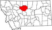 | |
| Towns | ||
| CDPs | ||
| Unincorporated communities | ||
| Ghost town | ||
| Indian reservation | ||
| Footnotes | ‡This populated place also has portions in an adjacent county or counties | |