Bijou Hills, South Dakota
| Bijou Hills, South Dakota | |
|---|---|
| Census-designated place | |
 Bijou Hills Location within the state of South Dakota | |
| Coordinates: 43°31′04″N 99°08′50″W / 43.51778°N 99.14722°WCoordinates: 43°31′04″N 99°08′50″W / 43.51778°N 99.14722°W | |
| Country | United States |
| State | South Dakota |
| Counties | Brule |
| Area | |
| • Total | 5.3 sq mi (13.6 km2) |
| • Land | 5.3 sq mi (13.6 km2) |
| • Water | 0.0 sq mi (0.0 km2) |
| Elevation | 1,770 ft (540 m) |
| Population (2010) | |
| • Total | 6 |
| • Density | 1.1/sq mi (0.44/km2) |
| Time zone | Central (CST) (UTC-6) |
| • Summer (DST) | CDT (UTC-5) |
| FIPS code | 46-05580 |
| GNIS feature ID | 1261095 |
Bijou Hills (Lakota: 'Wíyukeze Pahá'[1]) is an unincorporated community and census-designated place in Brule County, South Dakota, United States. The population was 6 according to the 2010 census.[2]
The CDP is located in southern Brule County, at the south base of a small ridge known as the Bijou Hills. The community is 1.2 miles (1.9 km) northeast of South Dakota Highway 50 and 18 miles (29 km) south of Interstate 90.
History
Bijou Hills was laid out in 1875, and named after a nearby mountain range.[3] A post office called Bijou Hills was established in 1877, and remained in operation until 1957.[4]
References
- ↑ Ullrich, Jan, ed. (2011). New Lakota Dictionary (2nd ed.). Bloomington, IN: Lakota Language Consortium. p. 863. ISBN 978-0-9761082-9-0. LCCN 2008922508.
- ↑ "Geographic Identifiers: 2010 Demographic Profile Data (G001): Bijou Hills CDP, South Dakota". U.S. Census Bureau, American Factfinder. Retrieved April 8, 2014.
- ↑ Federal Writers' Project (1940). South Dakota place-names, v.1-3. University of South Dakota. p. 26.
- ↑ "Brule County". Jim Forte Postal History. Archived from the original on 16 March 2005. Retrieved 26 January 2015.
Municipalities and communities of Brule County, South Dakota, United States | ||
|---|---|---|
| Cities | 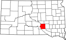 | |
| Town | ||
| CDPs | ||
| Unincorporated community | ||
| Townships |
| |
| Unorganized Territory |
| |
This article is issued from Wikipedia - version of the 11/2/2016. The text is available under the Creative Commons Attribution/Share Alike but additional terms may apply for the media files.