Ola, South Dakota
| Ola, South Dakota | |
|---|---|
| Census-designated place | |
 Ola Location within the state of South Dakota | |
| Coordinates: 43°36′02″N 99°12′38″W / 43.60056°N 99.21056°WCoordinates: 43°36′02″N 99°12′38″W / 43.60056°N 99.21056°W | |
| Country | United States |
| State | South Dakota |
| Counties | Brule |
| Area | |
| • Total | 4.0 sq mi (10.4 km2) |
| • Land | 4.0 sq mi (10.4 km2) |
| • Water | 0.0 sq mi (0.0 km2) |
| Elevation | 1,735 ft (529 m) |
| Population (2010) | |
| • Total | 13 |
| • Density | 3/sq mi (1.2/km2) |
| Time zone | Central (CST) (UTC-6) |
| • Summer (DST) | CDT (UTC-5) |
| FIPS code | 46-46700 |
| GNIS feature ID | 1261051 |
Ola is an unincorporated community and census-designated place in Brule County, South Dakota, United States. The population was 13 according to the 2010 census.[1]
The CDP is located in southern Brule County, 2 miles (3 km) west of South Dakota Highway 50 and 12 miles (19 km) south of Interstate 90.
References
- ↑ "Geographic Identifiers: 2010 Demographic Profile Data (G001): Ola CDP, South Dakota". U.S. Census Bureau, American Factfinder. Retrieved April 8, 2014.
Municipalities and communities of Brule County, South Dakota, United States | ||
|---|---|---|
| Cities | 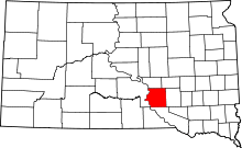 | |
| Town | ||
| CDPs | ||
| Unincorporated community | ||
| Townships |
| |
| Unorganized Territory |
| |
This article is issued from Wikipedia - version of the 4/8/2014. The text is available under the Creative Commons Attribution/Share Alike but additional terms may apply for the media files.