Binga District
Coordinates: 17°46′20″S 27°33′30″E / 17.77222°S 27.55833°E Binga District (Vinga District[1]) is a district of Zimbabwe in southern Africa.[2] It is located in Matabeleland North just south of Kariba Lake, across the lake from Zambia It lies along the hot and arid southern Zambezi Escarpment, a region that is in the territory of the tsetse fly, which transmits human sleeping sickness and animal trypanosomiasis.
Boundaries
Binga District is an area of land bounded by a line drawn from;
- a point on the Zimbabwe-Zambia international boundary at map reference 35KPM098348 on the 1:50 000 Map Sengwa Sound 1628C3, Edition 2, southwards direct to a point on the former Sengwa River course at map reference 35KPM114145 on the 1:50 000 Map Chiwa 1728A1, Edition 2;
- thence proceeding generally southwards up the Sengwa River to the eastern boundary of Chizarira National Park,
- thence generally southwest-wards along the eastern boundaries of Chizarira National Park and Busi Communal Land and westwards along the south- eastern boundary of Dandanda Communal Land;
- thence generally westwards along the boundaries of Dandanda Communal Land to its westernmost point;
- thence southwards along the westernmost boundary of Dandanda Communal land; thence eastwards along the northern boundary of Lubimbi Communal land up to the northernmost beacon of remainder of Lot 4 Karna Block;
- thence generally south-westwards along the northern-western boundaries of Remainder of Lot 4 Karna Block and Lot 7A Karna Block up the westernmost beacon of Lot 7 A Karna Block;
- thence proceeding generally westwards along the northern boundaries of Lot 8 Karna Block and the Remainder of Karna Block to exclude them up the intersection by the Shangani River;
- thence up the Shangani River to a point at a map reference 35KNK259556 on the 1:50 000 Map Kamativi 1827A3, edition 1,
- thence proceeding generally north-westwards to a point at map reference 35KNK249563 on the 1: 50 000 Map Kamativi 1827A3, Edition 1;
- thence proceeding generally northwards along the western and north-western boundaries of Lubimbi Communal Land to a point at map reference 35KNK315618 on the 1:50 000 Map Kamativi 1827A3, Edition 1;
- thence generally north-westwards along the south-western and western boundaries of Manjolo Communal Land to the southern boundary of Kavira Forest Land,
- thence westwards along the southern boundary of Kavira Forest Land to the Gwayi River,
- thence generally northwards down the Gwayi River to the Zimbabwe-Zambia international boundary;
- thence north-eastwards along the Zimbabwe- Zambia international boundary to the starting point.
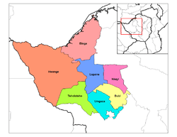
Administrave divisions and constituencies
There are twenty-one wards in the district, which is divided into two parliamentary constituencies: Binga North Constituency with twelve wards[3] and South Binga Constituency with nine wards.[4] The separate constituencies were created in 2008.[4]
Among the areas in Binga North Constituency are: Chizarira, Siabuwa, Cheete, Siansundu, Siantula, Mujere and Manjolo.
Settlements
Binga village[5] is by far one of the largest settlement. It lies on the south eastern shore of Lake Kariba. It was constructed to rehouse the BaTonga people whose homeland was flooded by the creation of the Kariba reservoir.[6] The Chibwatatata Hot Springs lie near the town. There are also settlements at:
- Chief Binga[7]
- Chief Dobola[8]
- Chief Saba[9]
- Chief Sikalenge[10]
- Chief Sikalenge[11]
- Chief Simupa Village[12]
- Chief Sinakooma[13]
- Chief Sinampande[14]
- Chief Sinakatenge Village[15]
- Chief Sinansengwe[16]
- Chief Siansaali Village[17]
- Impampa[18]
- James[19]
- Kabulawu[20]
- Kariyangwe[21]
- Lubimbi[22]
- Lusulu[23]
- Manjolo[24]
- Matinka[25]
- Mlibizi[26]
- Pashu[27]
- Saba[28]
- Siabuwa[29]
- Siamunchembu[30]
- Tinde [31]
- Zyakamana Village (Zikamanus)[32]
Economy and development
Binga District is one of the outposts of Zimbabwe that is underdeveloped, with limited access roads, especially during the rain season. It is also one of the most sparsely populated districts of the country.
The consumption of cannabis in the Binga District has been described as traditional in pre-colonial times,[33] and is considered to be an integral part of the Tonga culture.[34] However, it must be pointed out that consumption of cannabis is generally considered a devious pursuit especially in light of colonial Laws DANGEROUS DRUGS ACT, CAP 15:02 (Zimbabwe) to control the importation, exportation, production, possession, sale, distribution and use of dangerous drugs. There is a wrong impression among people from the rest of Zimbabwe that people from Binga are legally entitled to plant, harvest, process and smoke cannabis freely[35][36][37][38]
Notes and references
- ↑ UFI 2307497 Vinga (Variant - V) at GEOnet Names Server, United States National Geospatial-Intelligence Agency
- ↑ UFI 2307497 Binga District (Approved - N) at GEOnet Names Server, United States National Geospatial-Intelligence Agency
- ↑ "Binga North Constituency Profile" (PDF). Research Department of the Zimbabwe Parliament. 2011. Archived (PDF) from the original on 16 August 2015.
- 1 2 "Binga South Constituency Profile" (PDF). Research Department of the Zimbabwe Parliament. 2011.
- ↑ 17°37′27″S 27°20′28″E / 17.62417°S 27.34111°E, Binga (Approved - N) at GEOnet Names Server
- ↑ Shaver, Ruth Ann. "Brief History of the BaTonga People of the Zambezi River Valley - Zimbabwe". Brian & Ruthie Shaver's Guide to Various Community,Educational & Faith Based Service & Learning Resources. Archived from the original on 11 August 2011.
- ↑ 17°45′28″S 27°25′14″E / 17.75778°S 27.42056°E, Chief Binga (Approved - N) at GEOnet Names Server
- ↑ 18°07′05″S 27°26′25″E / 18.11806°S 27.44028°E, Chief Dobola (Approved - N) at GEOnet Names Server
- ↑ 18°01′06″S 27°08′08″E / 18.01833°S 27.13556°E, Chief Saba (Approved - N) at GEOnet Names Server
- ↑ 17°43′33″S 27°23′24″E / 17.72583°S 27.39000°E, Chief Sikalenge (Approved - N) at GEOnet Names Server
- ↑ 17°44′54″S 27°24′21″E / 17.74833°S 27.40583°E, Chief Sikalenge (Approved - N) at GEOnet Names Server
- ↑ 17°11′40″S 28°04′11″E / 17.19444°S 28.06972°E, Chief Simupa (Approved - N) at GEOnet Names Server
- ↑ 17°41′09″S 27°37′58″E / 17.68583°S 27.63278°E, Chief Sinakooma (Approved - N) at GEOnet Names Server
- ↑ 17°28′53″S 27°56′54″E / 17.48139°S 27.94833°E, Chief Sinampande (Approved - N) at GEOnet Names Server
- ↑ 17°09′06″S 28°06′44″E / 17.15167°S 28.11222°E, Chief Sinakatenges Village (Approved - N) at GEOnet Names Server
- ↑ 17°32′00″S 27°53′59″E / 17.53333°S 27.89972°E, Chief Sinansengwe (Approved - N) at GEOnet Names Server
- ↑ 18°00′27″S 27°33′58″E / 18.00750°S 27.56611°E, Chief Siansaali (Approved - N) at GEOnet Names Server
- ↑ 17°37′05″S 27°43′05″E / 17.61806°S 27.71806°E, Impampa (Approved - N) at GEOnet Names Server
- ↑ 17°54′17″S 27°17′20″E / 17.90472°S 27.28889°E, James (Approved - N) at GEOnet Names Server
- ↑ 17°43′23″S 27°17′08″E / 17.72306°S 27.28556°E, Kabulawu (Approved - N) at GEOnet Names Server
- ↑ 17°58′14″S 27°32′03″E / 17.97056°S 27.53417°E, Kariyangwe (Approved - N) at GEOnet Names Server
- ↑ 18°28′10″S 27°18′14″E / 18.46944°S 27.30389°E, Lubimbi (Approved - N) at GEOnet Names Server
- ↑ 18°03′53″S 27°49′56″E / 18.06472°S 27.83222°E, Lusulu (Approved - N) at GEOnet Names Server
- ↑ 17°44′55″S 27°24′21″E / 17.74861°S 27.40583°E, Manjolo School (Approved - N) at GEOnet Names Server
- ↑ 17°28′34″S 27°57′53″E / 17.47611°S 27.96472°E, Matinka (Approved - N) at GEOnet Names Server
- ↑ 17°56′18″S 27°04′33″E / 17.93833°S 27.07583°E, Mlibizi Fishing Camp (Approved - N) at GEOnet Names Server
- ↑ 18°13′08″S 27°23′39″E / 18.21889°S 27.39417°E, Pashu (Approved - N) at GEOnet Names Server
- ↑ 18°00′53″S 27°07′24″E / 18.01472°S 27.12333°E, Saba (Approved - N) at GEOnet Names Server
- ↑ 17°27′59″S 28°03′06″E / 17.46639°S 28.05167°E, Siabuwa (Approved - N) at GEOnet Names Server
- ↑ 17°29′11″S 27°52′55″E / 17.48639°S 27.88194°E, Siamunchembu (Approved - N) at GEOnet Names Server
- ↑ 18°15′08″S 27°10′53″E / 18.25222°S 27.18139°E, Tinde Mission (Approved - N) at GEOnet Names Server
- ↑ 18°13′17″S 27°56′54″E / 18.22139°S 27.94833°E, Zyakamana (Approved - N) at GEOnet Names Server
- ↑ Zeleza, Tiyambe; Dickson Eyoh (2003). Encyclopedia of Twentieth-century African History. Taylor & Francis. p. 25. ISBN 978-0-415-23479-5. External link in
|title=(help) - ↑ Arnett, Jeffrey Jensen (2007). International Encyclopedia of Adolescence: A Historical and Cultural Survey of Young People Around the World. CRC Press. p. 1115. ISBN 978-0-415-96667-2. External link in
|title=(help) - ↑ "Binga man sells mbanje for fees". NewsDay Zimbabwe. Retrieved 2016-02-10.
- ↑ "Binga man justifies mbanje smoking". NewsDay Zimbabwe. Retrieved 2016-02-10.
- ↑ Ziso, Big. "Forget Binga, I'm Off to Nyanga for My Mbanje Fix - Zimbo Jam". www.zimbojam.com. Archived from the original on 3 October 2015. Retrieved 2016-02-10.
- ↑ Nyathi, Phathisa (2005). Zimbabwe's Cultural Heritage. Bulawayo: 'Ama Books. pp. 72–73. ISBN 0-7974 2897-6.