Provinces of Zimbabwe
| Provinces of Zimbabwe | |
|---|---|
 | |
| Category | Unitary state |
| Location | Republic of Zimbabwe |
| Number | 10 Provinces |
| Populations | 1,200,337 (Bulawayo) – 2,123,132 (Harare Province) |
| Areas | 1,240 km2 (479 sq mi) (Bulawayo) - 194,310 km2 (75,025 sq mi) ( Matabeleland North) |
| Government | Provincal government, National government |
| Subdivisions | District |
 |
| This article is part of a series on the politics and government of Zimbabwe |
|
Legislature |
|
Judiciary |
|
National symbols |
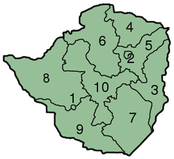
Zimbabwe is divided into 8 provinces and 2 cities with provincial status:
| Map key | Province | Capital | Area (km2) [1] | Population (2012 census) |
|---|---|---|---|---|
| 1 | Bulawayo Province | Bulawayo | 479 | 1,200,337 |
| 2 | Harare Province | Harare | 872 | 2,123,132 |
| 3 | Manicaland | Mutare | 36,459 | 1,752,698 |
| 4 | Mashonaland Central | Bindura | 28,347 | 1,152,520 |
| 5 | Mashonaland East | Marondera | 32,230 | 1,344,955 |
| 6 | Mashonaland West | Chinhoyi | 57,441 | 1,501,656 |
| 7 | Masvingo | Masvingo | 56,566 | 1,485,090 |
| 8 | Matabeleland North | Lupane | 75,025 | 749,017 |
| 9 | Matabeleland South | Gwanda | 54,172 | 683,893 |
| 10 | Midlands | Gweru | 49,166 | 1,614,941 |
See also
- Districts of Zimbabwe
- Municipalities of Zimbabwe
- List of provincial governors of Zimbabwe
- Senatorial constituencies of Zimbabwe
- ISO 3166-2:ZW
External links
References
This article is issued from Wikipedia - version of the 11/24/2016. The text is available under the Creative Commons Attribution/Share Alike but additional terms may apply for the media files.