Bird City, Kansas
| Bird City, Kansas | |
|---|---|
| City | |
 Location within Cheyenne County and Kansas | |
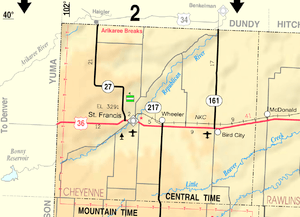 KDOT map of Cheyenne County (legend) | |
| Coordinates: 39°45′3″N 101°32′1″W / 39.75083°N 101.53361°WCoordinates: 39°45′3″N 101°32′1″W / 39.75083°N 101.53361°W | |
| Country | United States |
| State | Kansas |
| County | Cheyenne |
| Area[1] | |
| • Total | 2.23 sq mi (5.78 km2) |
| • Land | 2.23 sq mi (5.78 km2) |
| • Water | 0 sq mi (0 km2) |
| Elevation | 3,461 ft (1,055 m) |
| Population (2010)[2] | |
| • Total | 447 |
| • Estimate (2015)[3] | 436 |
| • Density | 200/sq mi (77/km2) |
| Time zone | Central (CST) (UTC-6) |
| • Summer (DST) | CDT (UTC-5) |
| ZIP code | 67731 |
| Area code(s) | 785 |
| FIPS code | 20-06825 [4] |
| GNIS feature ID | 0470980 [5] |
Bird City is a city in Cheyenne County, Kansas, United States. As of the 2010 census, the city population was 447.[6]
History
Bird City was founded in 1885.[7] It was named for Benjamin Bird, a cattleman.[8] The surrounding area was originally used predominately for livestock grazing.[9]
Bird City was a station and shipping point on the Chicago, Burlington and Quincy Railroad.[10]
Geography
Bird City is located at 39°45′3″N 101°32′1″W / 39.75083°N 101.53361°W (39.750950, -101.533480).[11] According to the United States Census Bureau, the city has a total area of 2.23 square miles (5.78 km2), all land.[1]
Climate
According to the Köppen Climate Classification system, Bird City has a semi-arid climate, abbreviated "BSk" on climate maps.[12]
Demographics
| Historical population | |||
|---|---|---|---|
| Census | Pop. | %± | |
| 1890 | 145 | — | |
| 1900 | 88 | −39.3% | |
| 1910 | 190 | 115.9% | |
| 1920 | 489 | 157.4% | |
| 1930 | 740 | 51.3% | |
| 1940 | 694 | −6.2% | |
| 1950 | 784 | 13.0% | |
| 1960 | 678 | −13.5% | |
| 1970 | 671 | −1.0% | |
| 1980 | 546 | −18.6% | |
| 1990 | 467 | −14.5% | |
| 2000 | 482 | 3.2% | |
| 2010 | 447 | −7.3% | |
| Est. 2015 | 436 | [3] | −2.5% |
| U.S. Decennial Census | |||
2010 census
As of the census[2] of 2010, there were 447 people, 211 households, and 118 families residing in the city. The population density was 200.4 inhabitants per square mile (77.4/km2). There were 264 housing units at an average density of 118.4 per square mile (45.7/km2). The racial makeup of the city was 96.2% White, 0.4% Native American, 0.9% from other races, and 2.5% from two or more races. Hispanic or Latino of any race were 15.0% of the population.
There were 211 households of which 24.2% had children under the age of 18 living with them, 48.3% were married couples living together, 7.1% had a female householder with no husband present, 0.5% had a male householder with no wife present, and 44.1% were non-families. 40.8% of all households were made up of individuals and 24.6% had someone living alone who was 65 years of age or older. The average household size was 2.12 and the average family size was 2.91.
The median age in the city was 47.4 years. 24.2% of residents were under the age of 18; 4% were between the ages of 18 and 24; 19.9% were from 25 to 44; 26.1% were from 45 to 64; and 25.7% were 65 years of age or older. The gender makeup of the city was 48.5% male and 51.5% female.
2000 census
As of the census[4] of 2000, there were 482 people, 232 households, and 128 families residing in the city. The population density was 216.1 people per square mile (83.5/km²). There were 285 housing units at an average density of 127.8 per square mile (49.3/km²). The racial makeup of the city was 99.17% White, 0.21% Native American, 0.21% from other races, and 0.41% from two or more races. Hispanic or Latino of any race were 2.90% of the population.
There were 232 households out of which 22.8% had children under the age of 18 living with them, 49.1% were married couples living together, 4.3% had a female householder with no husband present, and 44.4% were non-families. 43.1% of all households were made up of individuals and 28.4% had someone living alone who was 65 years of age or older. The average household size was 2.08 and the average family size was 2.88.
In the city the population was spread out with 23.9% under the age of 18, 3.7% from 18 to 24, 19.7% from 25 to 44, 19.1% from 45 to 64, and 33.6% who were 65 years of age or older. The median age was 48 years. For every 100 females there were 87.5 males. For every 100 females age 18 and over, there were 79.0 males.
The median income for a household in the city was $25,714, and the median income for a family was $32,589. Males had a median income of $24,531 versus $17,500 for females. The per capita income for the city was $16,680. About 15.0% of families and 17.7% of the population were below the poverty line, including 25.9% of those under age 18 and 9.2% of those age 65 or over.
Popular culture
Danna Nelson, the 1986 homecoming queen from Bird City appeared as a guest on Late Night with David Letterman. Host David Letterman chatted with her among other guests for the evening.[13]
References
- 1 2 "US Gazetteer files 2010". United States Census Bureau. Archived from the original on 2012-01-24. Retrieved 2012-07-06.
- 1 2 "American FactFinder". United States Census Bureau. Retrieved 2012-07-06.
- 1 2 "Annual Estimates of the Resident Population for Incorporated Places: April 1, 2010 to July 1, 2015". Retrieved July 2, 2016.
- 1 2 "American FactFinder". United States Census Bureau. Archived from the original on 2013-09-11. Retrieved 2008-01-31.
- ↑ "US Board on Geographic Names". United States Geological Survey. 2007-10-25. Retrieved 2008-01-31.
- ↑ "2010 City Population and Housing Occupancy Status". U.S. Census Bureau. Archived from the original on July 21, 2011. Retrieved March 6, 2011.
- ↑ "Cheyenne County". Blue Skyways. Kansas State Library. Retrieved 6 June 2014.
- ↑ "Profile for Bird City, Kansas". ePodunk. Retrieved 6 June 2014.
- ↑ "History". City of Bird City, Kansas. Retrieved 6 June 2014.
- ↑ Blackmar, Frank Wilson (1912). Kansas: A Cyclopedia of State History, Embracing Events, Institutions, Industries, Counties, Cities, Towns, Prominent Persons, Etc. Standard Publishing Company. p. 186.
- ↑ "US Gazetteer files: 2010, 2000, and 1990". United States Census Bureau. 2011-02-12. Retrieved 2011-04-23.
- ↑ Climate Summary for Bird City, Kansas
- ↑ "Late Night With David Letterman Season 5 Episode 130 Show #0788". TV.com. November 11, 1986. Retrieved April 19, 2016.
External links
| Wikimedia Commons has media related to Bird City, Kansas. |
- City
- Schools
- USD 103, local school district
- Maps
- Bird City Map, KDOT
Municipalities and communities of Cheyenne County, Kansas, United States | ||
|---|---|---|
| Cities |  | |
| Unincorporated communities | ||
| Townships | ||