Bloomingburg, New York
| Bloomingburg | |
| Village | |
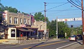 Intersection of Main, North and South streets downtown. | |
| Country | United States |
|---|---|
| State | New York |
| Region | Hudson Valley |
| County | Sullivan |
| Town | Mamakating |
| Landmark | Bloomingburg Reformed Protestant Dutch Church |
| River | Shawangunk Kill |
| Elevation | 515 ft (157 m) |
| Coordinates | 41°33′15″N 74°26′22″W / 41.55417°N 74.43944°WCoordinates: 41°33′15″N 74°26′22″W / 41.55417°N 74.43944°W |
| Length | 1 mi (2 km), NW/SE |
| Area | 0.3 sq mi (1 km2) |
| Population | 420 (2010) |
| Density | 1,113.7/sq mi (430/km2) |
| Founded | 1833 |
| Timezone | Eastern (EST) (UTC-5) |
| - summer (DST) | EDT (UTC-4) |
| ZIP Code | 12721 |
| Area code | 845 |
| Exchange | 733 |
| FIPS code | 36-06959 |
| GNIS feature ID | 0975768 |
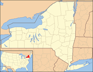 Location of Bloomingburg within New York
| |
Bloomingburg, previously Bloomingburgh, is a village in Sullivan County, New York, United States. The population was 420 at the 2010 census.
The Village of Bloomingburg is in the Town of Mamakating.
History
Bloomingburg's accepted incorporation date is 1833. It was the first county seat of Sullivan County, being located in the original county town of Mamakating. It prospered, first, as a center of commerce along the Newburgh–Cochecton Turnpike, then as a railway town serving vacationers in the mountains. Many guesthouses in the village were not rebuilt after the devastating fire of February 1922, and the village has been primarily an agricultural center ever since.
Camp Na-Sho-Pa, a summer sleep-away camp from 1937–2009, was located in Bloomingburg. Camp Echo has also been located in Bloomingburg for almost 90 years.
The Bloomingburg Reformed Protestant Dutch Church was listed on the National Register of Historic Places in 1980.[1]
A 396- home development known as Chestnut Ridge is being developed in Bloomingburg, with the first phase already open for sale.[2][3] The first approvals for the plan were given in 2006.[4] This is being developed by a Hasidic Jewish company, and many current residents of Bloomingburg perceive this as leading to more Hasidic Jews in the city. This led to various attempts by the village to stop the development.[5] The opposition did not organize until 2012 according to the leader of the anti-development coalition, Holly Roche, because it was not until that time that people realized the developers were Hasidic Jews and that the development would not be a low density golfing community as originally pitched, but a high density apartment block with different utility needs. In 2014 these Hasidic Jews, as well as others seeking to open a school, brought a suit against Bloomingburg for violating RLUIPA, the Fair Housing Act and the 1st and 14th amendments to the US constitution.[6]
Geography
Bloomingburg is located at 41°33′22″N 74°26′28″W / 41.55611°N 74.44111°W (41.556159, -74.441060).[7] The village's eastern boundary is the Shawangunk Kill, Dutch for "Shawangunk River", also the Orange County line at that point, with its western boundary a short distance up the Shawangunk Ridge. It is the only population center in Sullivan County entirely within the Hudson River watershed.
The northern and southern boundaries roughly parallel Main Street, also County Route 171, the former route of NY 17, which now bypasses the village to the north as an expressway. It is served by two exits on Route 17, one for Burlingham Road and the other, just over the county line, for NY 17K.
According to the United States Census Bureau, the village has a total area of 0.3 square miles (0.78 km2), all of it land.
Demographics
| Historical population | |||
|---|---|---|---|
| Census | Pop. | %± | |
| 1930 | 215 | — | |
| 1940 | 197 | −8.4% | |
| 1950 | 263 | 33.5% | |
| 1960 | 303 | 15.2% | |
| 1970 | 323 | 6.6% | |
| 1980 | 338 | 4.6% | |
| 1990 | 316 | −6.5% | |
| 2000 | 353 | 11.7% | |
| 2010 | 420 | 19.0% | |
| Est. 2015 | 411 | [8] | −2.1% |
As of the 2010 census Bloomingburg had a population of 420. 77.9% of the population was non-Hispanic whites, 4.5% non-Hispanic African American, 0.5% Native American, 1.0% Asian, 5.7% reporting two or more races and 13.3% Hispanic or Latino.[10]
As of the census[11] of 2000, there were 353 people, 146 households, and 94 families residing in the village. The population density was 1,113.7 people per square mile (425.9/km²). There were 181 housing units at an average density of 571.0 per square mile (218.4/km²). The racial makeup of the village was 92.92% White, 2.83% African American, 1.98% Asian, 0.57% from other races, and 1.70% from two or more races. Hispanic or Latino of any race were 7.93% of the population.
There were 146 households out of which 35.6% had children under the age of 18 living with them, 50.0% were married couples living together, 11.6% had a female householder with no husband present, and 35.6% were non-families. 29.5% of all households were made up of individuals and 10.3% had someone living alone who was 65 years of age or older. The average household size was 2.42 and the average family size was 3.04.
In the village the population was spread out with 27.8% under the age of 18, 9.3% from 18 to 24, 34.8% from 25 to 44, 16.1% from 45 to 64, and 11.9% who were 65 years of age or older. The median age was 32 years. For every 100 females there were 90.8 males. For every 100 females age 18 and over, there were 90.3 males.
The median income for a household in the village was $38,571, and the median income for a family was $41,111. Males had a median income of $35,938 versus $21,750 for females. The per capita income for the village was $21,441. About 17.0% of families and 11.1% of the population were below the poverty line, including 17.7% of those under age 18 and 8.7% of those age 65 or over.
Notable people
- Edward M. Hunter, Wisconsin State Senator and lawyer, was born in Bloomingburg.[12]
References
- ↑ National Park Service (2009-03-13). "National Register Information System". National Register of Historic Places. National Park Service.
- ↑ http://www.recordonline.com/article/20141007/NEWS/141009526
- ↑ http://bloomingburghomes.com/
- ↑ http://www.chestnutridgeseqra.com/
- ↑ Calder, Rich; Golding, Bruce (September 9, 2014). "Village trying to prevent Hasidic Jews from relocating there: suit". New York Post.
- ↑ "Religion Clause" September 9, 2014
- ↑ U.S. Geological Survey: Geographical Names Information System (GNIS). 2007-10-25. Retrieved 2008-01-31.
- ↑ "Annual Estimates of the Resident Population for Incorporated Places: April 1, 2010 to July 1, 2015". Retrieved July 2, 2016.
- ↑ "Census of Population and Housing". Census.gov. Archived from the original on May 11, 2015. Retrieved June 4, 2015.
- ↑ 2010 census data for Bloomingburg Archived November 29, 2014, at the Wayback Machine.
- ↑ United States Census Bureau: American FactFinder. Retrieved 2008-01-31.
- ↑ 'Memoirs of Milwaukee County: From the Earliest Times to the Present,' Jerome Anthony Watrous, Western Historical Association: 1909, Biographical Sketch of Charles F. Hunter, 1011-1012, (This has information about Charles F. Hunter's father Edward M. Hunter)
Municipalities and communities of Sullivan County, New York, United States | ||
|---|---|---|
| Towns | 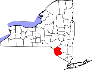 | |
| Villages | ||
| CDPs | ||
| Other hamlets | ||
| Indian reservation | ||
| Footnotes | ‡This populated place also has portions in another county or counties. | |