Tusten, New York
| Tusten, New York | |
|---|---|
| Town | |
 Tusten, New York Location within the state of New York | |
| Coordinates: 41°35′19″N 74°59′38″W / 41.58861°N 74.99389°W | |
| Country | United States |
| State | New York |
| County | Sullivan |
| Area | |
| • Total | 48.8 sq mi (126.4 km2) |
| • Land | 47.3 sq mi (122.4 km2) |
| • Water | 1.5 sq mi (4.0 km2) |
| Elevation | 1,115 ft (340 m) |
| Population (2010) | |
| • Total | 1,515 |
| Time zone | Eastern (EST) (UTC-5) |
| • Summer (DST) | EDT (UTC-4) |
| FIPS code | 36-75759 |
| GNIS feature ID | 0979565 |
Tusten is a town in Sullivan County in the U.S. state of New York. The population was 1,515 at the 2010 census. The name is derived from Benjamin Tusten, a military leader killed at the Battle of Minisink.
The Town of Tusten is located in southwestern part of the county.
History
The town was previously part of the Towns of Mamakating and Lumberland in 1853. Benjamin Homans was the first settler, setting himself up by Narrowsburg. The Ten Mile River Baptist Church and Tusten Stone Arch Bridge are listed on the National Register of Historic Places.[1]
Geography
The west town line, delineated by the Delaware River, is the border of Pennsylvania.
According to the United States Census Bureau, the town has a total area of 48.8 square miles (126 km2), of which, 47.3 square miles (123 km2) of it is land and 1.5 square miles (3.9 km2) of it (3.18%) is water.
Demographics
| Historical population | |||
|---|---|---|---|
| Census | Pop. | %± | |
| 1860 | 871 | — | |
| 1870 | 1,028 | 18.0% | |
| 1880 | 1,050 | 2.1% | |
| 1890 | 1,004 | −4.4% | |
| 1900 | 890 | −11.4% | |
| 1910 | 878 | −1.3% | |
| 1920 | 881 | 0.3% | |
| 1930 | 914 | 3.7% | |
| 1940 | 950 | 3.9% | |
| 1950 | 1,042 | 9.7% | |
| 1960 | 1,087 | 4.3% | |
| 1970 | 1,224 | 12.6% | |
| 1980 | 1,424 | 16.3% | |
| 1990 | 1,271 | −10.7% | |
| 2000 | 1,415 | 11.3% | |
| 2010 | 1,515 | 7.1% | |
| Est. 2014 | 1,504 | [2] | −0.7% |
As of the census[4] of 2000, there were 1,415 people, 583 households, and 367 families residing in the town. The population density was 29.9 people per square mile (11.6/km²). There were 1,008 housing units at an average density of 21.3 per square mile (8.2/km²). The racial makeup of the town was 89.12% White, 6.93% African American, 0.14% Native American, 0.92% Asian, 1.13% from other races, and 1.77% from two or more races. Hispanic or Latino of any race were 3.60% of the population.
There were 583 households out of which 26.2% had children under the age of 18 living with them, 49.6% were married couples living together, 8.6% had a female householder with no husband present, and 37.0% were non-families. 32.4% of all households were made up of individuals and 17.8% had someone living alone who was 65 years of age or older. The average household size was 2.30 and the average family size was 2.89.
In the town the population was spread out with 22.3% under the age of 18, 4.2% from 18 to 24, 24.1% from 25 to 44, 28.3% from 45 to 64, and 21.0% who were 65 years of age or older. The median age was 44 years. For every 100 females there were 103.9 males. For every 100 females age 18 and over, there were 105.8 males.
The median income for a household in the town was $38,824, and the median income for a family was $46,250. Males had a median income of $35,125 versus $25,938 for females. The per capita income for the town was $19,413. About 6.8% of families and 9.2% of the population were below the poverty line, including 8.9% of those under age 18 and 4.3% of those age 65 or over.
Communities and locations in Tusten
- Narrowsburg – A hamlet by the Delaware River. It was formerly called Homans Eddy.
- Beaver Brook Corners (or Beaver Brook) – A hamlet in the eastern part of the town.
- Feagles Lake – A small lake east of Narrowsburg.
- Hunts Corners – A hamlet east of Narrowsburg on Route 52.
- Lava – A hamlet east of Narrowsburg on Route 52.
- Neweiden – A hamlet southeast of Narrowsburg on the Ten Mile River, formerly called Swamp Mills.
- Smith Switch – A location in the northwest corner of the town by the Delaware River and on Route 97.
- Ten Mile River – A small river and the site of a large summer camp maintained by the Boy Scouts of America, located near Neweiden.
- Tusten – The hamlet of Tusten in the southwest part of the town on Route 97.
Notable people
- Benjamin Woodward, politician.
- Gustavus Adolphus Neumann, newspaper editor.
References
- ↑ National Park Service (2009-03-13). "National Register Information System". National Register of Historic Places. National Park Service.
- ↑ "Annual Estimates of the Resident Population for Incorporated Places: April 1, 2010 to July 1, 2014". Retrieved June 4, 2015.
- ↑ "Census of Population and Housing". Census.gov. Retrieved June 4, 2015.
- ↑ "American FactFinder". United States Census Bureau. Retrieved 2008-01-31.
External links
Coordinates: 41°33′19″N 75°01′09″W / 41.55528°N 75.01917°W
Municipalities and communities of Sullivan County, New York, United States | ||
|---|---|---|
| Towns | 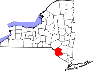 | |
| Villages | ||
| CDPs | ||
| Other hamlets | ||
| Indian reservation | ||
| Footnotes | ‡This populated place also has portions in another county or counties. | |