Boligee, Alabama
| Boligee, Alabama | |
|---|---|
| Town | |
|
The U.S. Post Office in Boligee, Alabama | |
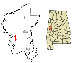 Location in Greene County and the state of Alabama | |
| Coordinates: 32°45′49″N 88°1′33″W / 32.76361°N 88.02583°W | |
| Country | United States |
| State | Alabama |
| County | Greene |
| Area | |
| • Total | 4 sq mi (10.2 km2) |
| • Land | 4 sq mi (10.2 km2) |
| • Water | 0 sq mi (0 km2) |
| Elevation | 121 ft (37 m) |
| Population (2010)[1] | |
| • Total | 328 |
| • Density | 83/sq mi (32.1/km2) |
| Time zone | Central (CST) (UTC-6) |
| • Summer (DST) | CDT (UTC-5) |
| ZIP code | 35443 |
| Area code(s) | 205 |
| FIPS code | 01-08104 |
| GNIS feature ID | 0114691 |

Boligee is a town in Greene County, Alabama, United States. At the 2010 census the population was 328,[1] down from 369 in 2000. Although Boligee appeared on the 1880 U.S. Census, according to the 1930 U.S. Census it did not incorporate until 1926, though another source cited 1927.[2]
Boligee has one site listed on the National Register of Historic Places, Boligee Hill.[3]
Geography
Boligee is located at 32°45′50″N 88°1′33″W / 32.76389°N 88.02583°W (32.763768, -88.025968).[4]
According to the U.S. Census Bureau, the town has a total area of 4.0 square miles (10 km2), all land.
Demographics
| Historical population | |||
|---|---|---|---|
| Census | Pop. | %± | |
| 1880 | 36 | — | |
| 1930 | 178 | — | |
| 1940 | 241 | 35.4% | |
| 1950 | 168 | −30.3% | |
| 1960 | 134 | −20.2% | |
| 1970 | 225 | 67.9% | |
| 1980 | 164 | −27.1% | |
| 1990 | 268 | 63.4% | |
| 2000 | 369 | 37.7% | |
| 2010 | 328 | −11.1% | |
| Est. 2015 | 309 | [5] | −5.8% |
| U.S. Decennial Census[6] 2013 Estimate[7] | |||
As of the census[8] of 2000, there were 369 people, 150 households, and 105 families residing in the town. The population density was 93.3 people per square mile (36.0/km2). There were 179 housing units at an average density of 45.2 per square mile (17.5/km2). The racial makeup of the town was 10.57% White, 88.89% Black or African American, and 0.54% from two or more races. 1.90% of the population were Hispanic or Latino of any race.
There were 150 households out of which 44.0% had children under the age of 18 living with them, 26.0% were married couples living together, 41.3% had a female householder with no husband present, and 30.0% were non-families. 27.3% of all households were made up of individuals and 10.0% had someone living alone who was 65 years of age or older. The average household size was 2.46 and the average family size was 2.99.
In the town the population was spread out with 35.2% under the age of 18, 14.6% from 18 to 24, 19.8% from 25 to 44, 18.7% from 45 to 64, and 11.7% who were 65 years of age or older. The median age was 25 years. For every 100 females there were 69.3 males. For every 100 females age 18 and over, there were 60.4 males.
The median income for a household in the town was $15,000, and the median income for a family was $16,146. Males had a median income of $23,750 versus $21,000 for females. The per capita income for the town was $7,909. About 41.4% of families and 44.9% of the population were below the poverty line, including 63.3% of those under age 18 and 10.3% of those age 65 or over.
Notable people
- Emma Didlake, United States veteran
- William P. G. Harding, American banker and managing director of the War Finance Corporation
- Charles Hays, Confederate major who became a Republican Congressman.
- Brad Hubbert, Played in the 1967 American Football League All-Star game.
Gallery
Below are photographs taken in Boligee as part of the Historic American Buildings Survey:
-
%2C_U.S._Route_11_and_County_Road_19_vicinity%2C_Boligee%2C_Greene_County%2C_AL_HABS_ALA%2C32-BOLI.V%2C2-1.tif.jpg)
Weston House and Schoolhouse
-
_AND_WEST_SIDE_-_Beth_Salem_Presbyterian_Church%2C_County_Road_1%2C_Boligee%2C_Greene_County%2C_AL_HABS_ALA%2C32-BOLI%2C1-1.tif.jpg)
Beth Salem Presbyterian Church
-
_-_Hill_of_Howth%2C_County_Road_19%2C_Boligee%2C_Greene_County%2C_AL_HABS_ALA%2C32-BOLI.V%2C1-2.tif.jpg)
Hill of Howth
-
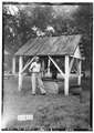
Old well located at Hill of Howth
References
- 1 2 "Geographic Identifiers: 2010 Demographic Profile Data (G001): Boligee town, Alabama". U.S. Census Bureau, American Factfinder. Retrieved October 28, 2016.
- ↑ http://www.encyclopediaofalabama.org/article/h-3430
- ↑ National Park Service (2008-04-15). "National Register Information System". National Register of Historic Places. National Park Service.
- ↑ "US Gazetteer files: 2010, 2000, and 1990". United States Census Bureau. 2011-02-12. Retrieved 2011-04-23.
- ↑ "Annual Estimates of the Resident Population for Incorporated Places: April 1, 2010 to July 1, 2015". Retrieved July 2, 2016.
- ↑ "U.S. Decennial Census". Census.gov. Archived from the original on May 11, 2015. Retrieved June 6, 2013.
- ↑ "Annual Estimates of the Resident Population: April 1, 2010 to July 1, 2013". Retrieved June 3, 2014.
- ↑ "American FactFinder". United States Census Bureau. Archived from the original on 2013-09-11. Retrieved 2008-01-31.
Coordinates: 32°45′50″N 88°01′33″W / 32.763768°N 88.025968°W
Municipalities and communities of Greene County, Alabama, United States | ||
|---|---|---|
| Cities | 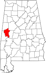 | |
| Towns | ||
| Unincorporated communities | ||