Østfold
| Østfold fylke | ||
|---|---|---|
| County | ||
 | ||
| ||
 Østfold within Norway | ||
| Country | Norway | |
| County | Østfold | |
| Region | Østlandet | |
| County ID | NO-01 | |
| Administrative centre | Sarpsborg | |
| Government | ||
| • Governor |
Anne Enger Senterpartiet (2003–present) | |
| • County mayor |
Ole Haabeth Arbeiderpartiet (2007–present) | |
| Area | ||
| • Total | 4,180.7 km2 (1,614.2 sq mi) | |
| • Land | 3,887 km2 (1,501 sq mi) | |
| Area rank | #17 in Norway, 1.28% of Norway's land area | |
| Population (2014) | ||
| • Total | 284,962 | |
| • Rank | 6 (5.61% of country) | |
| • Density | 68/km2 (180/sq mi) | |
| • Change (10 years) | 7.5 % | |
| Demonym(s) | Østfolding | |
| Time zone | CET (UTC+01) | |
| • Summer (DST) | CEST (UTC+02) | |
| Official language form | Bokmål | |
| Income (per capita) | 138,600 NOK | |
| GDP (per capita) | 200,084 NOK (2001) | |
| GDP national rank | 8 (3.30% of country) | |
| Website | www.ostfold-f.kommune.no | |
|
| ||

| Historical population | ||
|---|---|---|
| Year | Pop. | ±% |
| 1951 | 185,492 | — |
| 1961 | 202,751 | +9.3% |
| 1971 | 221,386 | +9.2% |
| 1981 | 233,301 | +5.4% |
| 1991 | 238,345 | +2.2% |
| 2001 | 251,032 | +5.3% |
| 2011 | 274,827 | +9.5% |
| 2021? | 309,613 | +12.7% |
| 2031? | 339,601 | +9.7% |
| Source: Statistics Norway.[1] | ||
Østfold [ˈœstˈfɔl] (![]() listen) is a county in southeastern Norway, bordering Akershus and southwestern Sweden (Västra Götaland County and Värmland), while Buskerud and Vestfold are on the other side of Oslofjord. The county's administrative seat is Sarpsborg.
listen) is a county in southeastern Norway, bordering Akershus and southwestern Sweden (Västra Götaland County and Värmland), while Buskerud and Vestfold are on the other side of Oslofjord. The county's administrative seat is Sarpsborg.
Many manufacturing facilities are situated here, such as the world's most advanced biorefinery, Borregaard in Sarpsborg. Moss (Moss Verft) and Fredrikstad have shipyards. There are granite mines in Østfold and stone from these were used by Gustav Vigeland.
The county slogan is "The heartland of Scandinavia". The local dialect is characterized by its geographical proximity to Sweden.
The name
The old name of the Oslofjord was Fold; Østfold means 'the region east of the Fold' (see also Vestfold). The name was first recorded in 1543; in the Middle Ages the name of the county was Borgarsysla 'the county/sýsla of the city Borg (now Sarpsborg)'. Later, when Norway was under Danish rule, the Danish king divided the area into many baronies. These were merged into one county (amt) in 1662 - and it was then named Smaalenenes Amt 'the amt consisting of small len'. The name was changed back to Østfold in 1919.
History
Østfold is among the nation's oldest inhabited regions, with petroglyphs (rock drawings) and burial mounds throughout the area.
In the Viking Age, the area was part of Vingulmark, which in turn was part of Viken and included Båhuslen. It was partly under Danish rule until the time of Harald Fairhair.
Later, when Norway was under Danish rule, the Danish king divided the area into many baronies. The barony of Heggen og Frøland, consisting of the municipalities Askim, Eidsberg and Trøgstad, originally belonged to Akershus - but it was transferred to Østfold in 1768.
Geography
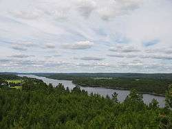
Østfold sits between the Oslo Fjord and Sweden. It is dominated by flat landscape with a lot of woodland in the north and along the Swedish border, a major lake system in the central part, and densely populated lowland area along the coast, with a relatively large archipelago.
Norway’s longest river, the Glomma, flows through the county and out into the Oslo Fjord in Fredrikstad.
Demography
Most of the county's population is located in the coastal area. The cities of Moss, Sarpsborg, Fredrikstad and Halden are situated here, along with some relatively highly populated rural municipalities. Including these coastal cities, Østfold also has another two cities, Askim and Mysen.
Transport and infrastructure
Østfold is located strategically between Oslo and Sweden. The main highway E6 between Oslo and Gothenburg runs as a motorway through the county from the southern border with Sweden and the border with Akershus county. The main highway E18 between Oslo and Stockholm goes through the county from the Swedish border in a southeast-northwest direction. The railway from Oslo to Gothenburg is running more or less parallelly with E6, and there is also a railway between Ski and Sarpsborg that covers the inner part. Moss Airport in Rygge - is the only public airport in the county. Ryanair is the main company supplying this airport with international flights. The airport serves as an addition to Oslo Airport, Gardermoen, with a population of more than 2 million people within two hours distance.
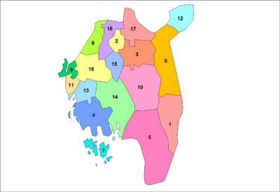
Municipalities
Østfold has 18 municipalities:
 |
Coat of arms
The coat of arms is from modern times (1958). The lines represent sunrays at sunrise in the east. (See above under the name.) They also represent the worship of the Sun in the Bronze Age (depicted in several rock carvings found in the county).
Notable people
- Roald Amundsen (1872–1928) - Explorer of polar regions
- Berit Ås - Politician, professor and feminist.
- Thea Foss (1857–1927) - founder of Foss Maritime
- Hans Nielsen Hauge - (3 April 1771 – 29 March 1824) - Lay preachers
- Egil Olsen - Norwegian Football coach.
- Karl Ouren (1882–1943) - Norwegian-American artist
- Petter Solberg - Rally driver
- Nils Otto Tank (1800–1864) - Moravian Church religious leader
- Harald Zwart - Movie director and producer
External links
| Wikimedia Commons has media related to Østfold. |
| Wikivoyage has a travel guide for Østfold. |
- Østfold fylke website (in Norwegian and English)
- Statistics and basic interpretation regarding Østfold (in Norwegian)
- Excavation of longhouse from the Roman Iron Age
References
- Notes

Coordinates: 59°20′00″N 11°20′00″E / 59.33333°N 11.33333°E