Boston, Lincolnshire
| Boston | |
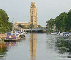 St Botolph's Church viewed from the river |
|
 Boston |
|
| Area | 18.42 km2 (7.11 sq mi) |
|---|---|
| Population | 66,900 (ONS) |
| – density | 3,632/km2 (9,410/sq mi) |
| OS grid reference | TF329437 |
| – London | 100 mi (160 km) S |
| District | Boston |
| Shire county | Lincolnshire |
| Region | East Midlands |
| Country | England |
| Sovereign state | United Kingdom |
| Post town | BOSTON |
| Postcode district | PE20. PE21, PE22 |
| Dialling code | 01205 |
| Police | Lincolnshire |
| Fire | Lincolnshire |
| Ambulance | East Midlands |
| EU Parliament | East Midlands |
| UK Parliament | Boston and Skegness |
|
|
Coordinates: 52°58′26″N 0°01′17″W / 52.974°N 0.0214°W
Boston (![]() i/ˈbɒstən/) is a town and small port in Lincolnshire, on the east coast of England. It is the largest town of the wider Borough of Boston local government district. The borough had a total population of 66,900, at the ONS mid 2015 estimates,[1] while the town itself had a population of 35,124 at the 2001 census.[2] It is due north of Greenwich on the Prime Meridian.
i/ˈbɒstən/) is a town and small port in Lincolnshire, on the east coast of England. It is the largest town of the wider Borough of Boston local government district. The borough had a total population of 66,900, at the ONS mid 2015 estimates,[1] while the town itself had a population of 35,124 at the 2001 census.[2] It is due north of Greenwich on the Prime Meridian.
Boston's most notable landmark is St Botolph's Church ("The Stump"), said to be the largest parish church in England,[3] with one of the taller towers in England[4] visible for miles around from the flat lands of Lincolnshire. Residents of Boston are known as Bostonians. Emigrants from Boston named several other settlements after the town, most notably Boston, Massachusetts, in the United States.
Name
The name "Boston" is said to be a contraction of "Saint Botolph's town",[5] "stone", or "tun" (Old English, Norse and present Norwegian) for a hamlet or farm, hence the Latin villa Sancti Botulfi "St. Botulf's village").[6] The town's link to the saint's life is probably apocryphal, but the name may have arisen from confusion as to the site of his monastery or owing to his patronage of the parish church.
History
Early history
The town was once held to have been a Roman settlement, but there is no evidence that this is the case.[5] Similarly, it is often linked to the monastery established by the Saxon monk Botolph at "Icanhoe" on the Witham in AD 654 and destroyed by the Vikings in 870,[5] but this is now doubted by modern historians. The early medieval geography of The Fens was much more fluid than it is today and, at that time, the Witham did not flow near the site of Boston. Botolph's establishment is most likely to have been in Suffolk. However, he was a popular missionary and saint, to whom many churches between Yorkshire and Sussex (including that Boston's) are dedicated.
The 1086 Domesday Book does not mention Boston by name,[7] but nearby settlements of the tenant-in-chief Count Alan Rufus of Brittany are covered. Its present territory was probably then part of the grant of Skirbeck,[7] part of the very wealthy manor of Drayton, which before 1066 had been owned by Ralph the Staller, Edward the Confessor's Earl of East Anglia. Skirbeck had two churches and one is likely to have been that dedicated to St Botolph, in what was consequently Botolph's town. Skirbeck (map) is now considered part of Boston, but the name remains, as a church parish and an electoral ward.
The order of importance was the other way round, when the Boston quarter of Skirbeck developed at the head of the Haven, which lies under the present Market Place. At that stage, The Haven was the tidal part of the stream, now represented by the Stone Bridge Drain (map), which carried the water from the East and West Fens. The line of the road through Wide Bargate, to A52 and A16, is likely to have developed on its marine silt levees . It led, as it does now, to the relatively high ground at Sibsey (map), and thence to Lindsey.
The reason for the original development of the town, away from the centre of Skirbeck, was that Boston lay on the point where navigable tidal water was alongside the land route, which used the Devensian terminal moraine ridge at Sibsey, between the upland of East Lindsey and the three routes to the south of Boston:
- The coastal route, on the marine silts, crossed the mouth of Bicker Haven towards Spalding.
- The Sleaford route, into Kesteven, passed via Swineshead (map), thence following the old course of the River Slea, on its marine silt levee.
- The Salters' Way route into Kesteven, left Holland from Donington. This route was much more thoroughly developed, in the later Medieval period, by Bridge End Priory (map).
The River Witham seems to have joined The Haven after the flood of September 1014, having abandoned the port of Drayton, on what subsequently became known as Bicker Haven. The predecessor of Ralph the Staller owned most of both Skirbeck and Drayton, so it was a relatively simple task to transfer his business from Drayton, but the Domesday Book of 1086 still records his source of income in Boston under the heading of Drayton, so Boston's name is famously not mentioned. The Town Bridge still maintains the pre-flood route, along the old Haven bank.
Growth
After the Norman Conquest, Ralph the Staller's property was taken over by Count Alan.[8] It subsequently came to be attached to the Earldom of Richmond, North Yorkshire, and known as the Richmond Fee. It lay on the left bank of The Haven.
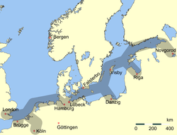
During the eleventh and twelfth centuries, Boston grew into a notable town and port.[9] In 1204, King John vested sole control over the town in his bailiff.[7] That year[5] or the next,[7] he levied a "fifteenth" tax (quinzieme) of 6.67% on the moveable goods of merchants in the ports of England: the merchants of Boston paid £780, the highest in the kingdom after London's £836.[5][10] Thus by the opening of the thirteenth century, it was already significant in trade with the continent of Europe and ranked as a port of the Hanseatic League.[11][12] Edward III named it a staple port for the wool trade in 1369.[7] Apart from wool, Boston also exported salt, produced locally on the Holland coast, grain, produced up-river, and lead, produced in Derbyshire and brought via Lincoln, up-river.
A quarrel between the local and foreign merchants led to the withdrawal of the Hansards[5] around 1470.[7] Around the same time, the decline of the local guilds[7] and shift towards domestic weaving of English wool (conducted in other areas of the country) led to a near-complete collapse of the town's foreign trade.[7] The silting of the Haven only furthered the town's decline.
At the Dissolution of the Monasteries by Henry VIII during the English Reformation, Boston's Dominican, Franciscan, Carmelite, and Augustinian friaries—erected during the boom years of the 13th and 14th centuries—were all expropriated. The refectory of the Dominican friary was eventually converted into a theatre in 1965 and now houses the Blackfriars Arts Centre.
Henry VIII granted the town its charter in 1545[13] and Boston had two Members of Parliament from 1552.
17th and 18th centuries

The staple trade made Boston a centre of intellectual influence from the Continent, including the teachings of John Calvin that became known as Calvinism. This, in turn, revolutionised the Christian beliefs and practices of many Bostonians and residents of the neighbouring shires of England. In 1607 a group of pilgrims from Nottinghamshire led by William Brewster and William Bradford attempted to escape pressure to conform with the teaching of the English church by going to the Netherlands from Boston. At that time unsanctioned emigration was illegal, and they were brought before the court in the Guildhall. Most of the pilgrims were released fairly soon and the following year, set sail for the Netherlands, settling in Leiden. In 1620, several of these were among the group who moved to New England in the Mayflower.
Boston remained a hotbed of religious dissent. In 1612 John Cotton became the Vicar of St Botolph's and, although viewed askance by the Church of England for his non-conformist preaching, became responsible for a large increase in Church attendance. He encouraged those who disliked the lack of religious freedom in England to join the Massachusetts Bay Company, and later helped to found the city of Boston, Massachusetts, which he was instrumental in naming. Unable to tolerate the religious situation any longer he eventually emigrated himself in 1633.
At the same time, work on draining the fens to the west of Boston was begun, a scheme which displeased many whose livelihoods were at risk. (One of the sources of livelihood obtained from the fen was fowling, supplying ducks and geese for meat and in addition the processing of their feathers and down for use in mattresses and pillows. The feathery aspect of this is still reflected in the presence of the bedding company named Fogarty, nearby in Fishtoft.) This and the religious friction put Boston into the parliamentarian camp in the Civil War which in England began in 1642. The chief backer of the drainage locally, Lord Lindsey, was shot in the first battle and the fens returned to their accustomed dampness until after 1750.
The later eighteenth century saw a revival when the Fens began to be effectively drained. The Act of Parliament permitting the embanking and straightening of the fenland Witham was dated 1762. A sluice, called for in the Act, was designed to help scour out The Haven. The land proved to be fertile, and Boston began exporting cereals to London. In 1774 the first financial bank was opened, and in 1776 an Act of Parliament allowed watchmen to begin patrolling the streets at night.
Modern history
In the 19th century, the names of Howden, a firm located near the Grand Sluice; and Tuxford, near the Maud Foster Sluice, were respected among engineers for their steam road locomotives, threshing engines and the like. Howden developed his business from making steam engines for river boats while Tuxford began as a miller and millwright. His mill was once prominent near Skirbeck Church, just to the east of the Maud Foster Drain.
The railway reached the town in 1848, and it was briefly on the main line from London to the North. The area between the Black Sluice and the railway station was mainly railway yard and the railway company's main depôt. The latter facility moved to Doncaster when the modern main line was opened. Boston remained something of a local railway hub well into the 20th century, moving the produce of the district and the trade of the dock, plus the excursion trade to Skegness and similar places. But it was much quieter by the time of the Beeching cuts of the 1960s.
Boston once again became a significant port in trade and fishing in 1884, when the new dock with its associated wharves on The Haven were constructed. It continued as a working port, exporting grain, fertiliser, and importing timber, although much of the fishing trade was moved out in the inter-war period.
During the First World War many of the town's trawlermen, together with those from Grimsby, were taken prisoner after their ships were sunk by German raiders in the North Sea. Their families did not know what had happened to them until late September 1914. The men were taken to Sennelager camp, then on to Ruhleben POW camp where most remained till repatriated in 1918. There is a full report of their homecoming in the Lincolnshire Standard newspaper, January 1918. Meanwhile, the port was used by hospital ships and some 4,000 sick or wounded troops passed through Boston.[14]
The first cinema opened in 1910, and the town was used by film makers during the Second World War to represent the Netherlands when the real thing was not available for filming. In 1913 a new Town Bridge was constructed. Central Park was purchased in 1919, and is now one of the focal points of the town. Electricity came to Boston during the early part of the century, and electrical street lighting was provided from 1924.
In the Second World War the borough lost 17 civilian dead through enemy air raids.[15] A memorial in Boston Cemetery commemorates them.[14]
The Haven Bridge, which now carries the two trunk roads over the river, was opened in 1966, and the new road built in the early 1970s rather separated Skirbeck from Boston; but the town largely avoided the development boom of the 1960s. A shopping centre, named the Pescod Centre, opened in 2004, bringing many new shops into the town. Further development was planned as of 2012.
There had been widespread disillusionment with what was perceived as the somewhat apathetic and incompetent running of the local council. In the Local Elections of 2007 this contributed to the overwhelming victory of a small bypass pressure group over the traditional political parties. Describing their victory, the new council leader Richard Austin said: "We knew that the mood of the people of Boston was very black and they really do want something to happen to Boston that isn't happening at the moment. "It's only a reflection of this black mood of the people of Boston."[16]
Boston United football club was relegated after losing its final match of the 2006/7 season against Wrexham, and following some financial irregularities during Steve Evans' time as manager of the club. A report, cited in The Sun in 2008, highlighted that Boston has the highest number of immigrants per capita of any town in Britain (an estimated one-quarter of the population are immigrants).[17]
Transport
Railway
The railways came to Boston in 1848 following the building of The East Lincolnshire Railway from Grimsby to Boston and the simultaneous building of the Lincolnshire Loop Line by the Great Northern Railway which ran between Peterborough and York via Boston, Lincoln and Doncaster. This line was built before the East Coast Main Line and for a short while put Boston on the map as the GNR's main Locomotive Works before it was relocated to Doncaster in 1852.
Boston railway station is served by East Midland Trains on the Poacher Line from Grantham to Skegness. It was the southern terminus of the East Lincolnshire Line to Louth and Grimsby until closure in 1970.
Politics
Boston residents voted strongly (76% with 77% participation) in favour of leaving the European Union on 23 June 2016.[18]
Boston bypass
In May 2007 a single-issue political party, the Independent Bypass Group, campaigning for a bypass to be built around Boston, Lincolnshire, took control of Boston Borough Council, removing the Labour Party majority.[19]
Governance
Boston received its charter in 1545. It is the main settlement in the Boston local government district of Lincolnshire which includes the unparished town of Boston and eighteen other civil parishes.
Electoral wards
In 2015, the Boston Borough council consisted of 30 members:[20]
- Coastal Ward elects two councillors
- Fenside Ward elects two councillors.
- Fishtoft Ward elects three councillors.
- Five Villages Ward elects two councillors.
- Kirton & Frampton Ward elects three councillors.
- Old Leake & Wrangle elects two councillors
- Skirbeck Ward elects three councillors.
- Staniland Ward elects two councillors.
- Station Ward elects one councillor.
- St Thomas Ward elects one councillor.
- Swineshead & Holland Ward elects two councillors.
- Trinity Ward elects two councillors.
- West Ward elects one councillor.
- Witham Ward elects two councillors.
- Wyberton Ward elects two councillors.
In the local elections of 2007, many local councillors from the major parties were displaced by independent candidates whose main issue as a group is the construction of a road bypass which they believe is being deliberately denied by the Lincoln-centric members of the Lincolnshire County Council. However, in 2011, the Conservative party took control with a majority,[21] effectively removing the previous administration.
Nationally Boston is in the East Midlands European Parliament constituency, which elects six members. At the national level, the town is part of the Boston and Skegness parliamentary constituency, currently represented by Conservative Matt Warman.The town was previously represented in parliament for 35 years by Conservative Sir Richard Body.
Demography
Population
According to the 2001 census, there were 35,124 people residing in Boston town, of whom 48.2% were male and 51.8% were female. Children under five accounted for approximately 5% of the population. 23% of the resident population in Boston were of retirement age. In the 2011 census the Borough of Boston had a population of 64,600 with 15% of the population having been born outside of the UK and 11% having been born in EU accession countries (2001-2011) such as Poland and Lithuania.[22] The non-white population made up 2.4% of the total population in 2011.[22]
Religion
80% of the population are Christians, the next highest religious minority were Hindus making up 0.7%.
Arts and culture
Boston has historically had strong cultural connections to the Netherlands, and Dutch influence can be found in its architecture.[18]
Landmarks
Some of the most interesting things to be seen in Boston lie not in the usual list of tourist features, but in the area of civil engineering. However, there are remarkable sights of the more usual sort:
The parish church of Saint Botolph is known locally as The Stump and is renowned for its lantern interior and 52 misericords.

The Grand Sluice is disguised by railway and road bridges, but it is there, keeping the tide out of the Fens and twice a day, allowing the water from the upland to scour the Haven. Not far away, in the opposite direction, was the boyhood home of John Foxe, the author of Foxe's Book of Martyrs.
The Town Bridge maintains the line of the road to Lindsey and from its western end, looking at the river side of the Exchange Building to the right, it is possible to see how the two ends of the building, founded on the natural levees of The Haven, have stood firm while the middle has sunk into the infill of the former river.
From 1552, the Bostonians used to have their jail near The Stump (about where the red car in the photograph is located). This is likely to be where the Scrooby Pilgrims were imprisoned in 1607. The lawyers' quarter is still in use, just to the north of the church.
A statue of the founder of The Illustrated London News, Herbert Ingram is now located in front of The Stump (see photograph). The statue was designed by Alexander Munro and was unveiled in October 1862. The allegorical figure, at the base of the monument, is a reference to Ingram's efforts to bring the first piped water to the town. He was also instrumental in bringing the railways to Boston. Born in nearby Paddock Grove, son of a butcher,[23] he was also MP for Boston, from 1856, until his death in 1860, in a shipping accident on Lake Michigan.
The market, held on Saturdays and Wednesdays, in the Market Place and also on Wide Bargate on Wednesday. Market Place and Strait Bargate are the retail hub of the town centre. Coincidentally, No.1 Market Place and No.1 Strait Bargate are the same building.
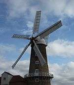
The seven-storeyed Maud Foster Tower Windmill, completed in 1819, by millwrights Norman & Smithson of Kingston upon Hull for Issac and Thomas Reckitt, is currently the tallest operating windmill in England (80 feet or 24.4 metres to the top of the cap), following extensive restoration during the 1980s and early 1990s and is now a working museum. The tall mill, without the usual tar coating in Lincs, stands on the dyke above the drain it is named after and is unusual in having an odd number (five) of sails.
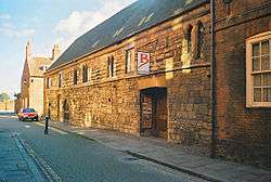
The Boston Guildhall in which the Pilgrim Fathers were tried, on the first floor, by the magistrates, was converted into a museum in 1929. The American Room was opened by the U.S. Ambassador, Joseph P. Kennedy, Sr., in 1938. The cells in which the pilgrims are said to have been held at the time of their trial are on the ground floor. In 2005 it was closed for repair and refurbishment.
The Pilgrim Fathers Memorial is located on the north bank of The Haven a few miles outside the town. It was here at Scotia Creek, that the pilgrims made their first attempt to leave for the Dutch Republic in 1607.

The ruined Hussey Tower is all that remains of a medieval brick fortified house.[24] 2 miles (3 km) east, Rochford Tower is another medieval tower house.[25]
In Skirbeck Quarter, on the right bank of The Haven, is the Black Sluice, the outfall of the South Forty-Foot Drain.
The Prime Meridian passes through the eastern side of Boston, marked by the fairly modern, suburban Meridian Road (PE21 0NB), which straddles the line the road was named after.
The oldest landmark is the Boston May Fair which has been held in the town every year since at least 1125. This fair is held during the first week of May, and is one of the largest outdoor fairs in the country. By tradition, the fair was officially opened by the incumbent mayor at 11 am on the May Day bank holiday. However this is now not the case.
The Haven Gallery, opened in 2005, was closed to the public in 2010 in a cost-cutting measure by Boston Borough Council.
Frampton Marsh and Freiston Shore are two nature reserves, managed by the RSPB, which lie on The Wash coast on either side of the mouth of The Haven.
In popular culture
- The novel The Last Dickens is set in Boston.
- Boston is often assumed to be the prototype for Flaxborough, in the detective novels of Colin Watson.
- Boston was the birthplace of the 19th century author and poet Jean Ingelow.
- Boston was also the Dutch town in One of Our Aircraft Is Missing, with scenes showing the Stump, externally and internally, and also the dock swing bridge on the River Haven.
- Boston is mentioned several times in the English band To Kill a King's EP My Crooked Saint.
- Boston may have been used in Anthony Horowitz' book Oblivion in which he describes the village with the church of St Botolphs.
Local economy
Boston's most important industries are food production, including vegetables and potatoes; road haulage and logistics companies that carry the food; the Port of Boston which handles more than one million tons of cargo per year including the import of steel and timber and the export of grain and recyclable materials; and also shellfishing, other light industry and tourism. The port is connected by rail, with steel imports going by rail each day to Washwood Heath in Birmingham, and the port and town are also connected by trunk roads including the A16 and the A52.
Boston has two weekly newspapers, The Boston Standard and The Boston Target, and a community radio station called Endeavour Radio.[26]
Boston's market[27] is held every Wednesday and Saturday[28] in one of England's largest market places, with an additional market and outside auction held on Wednesdays on Bargate Green.
Boston has a theatre and arts centre called Blackfriars[29] which is housed in the oldest building in Boston town centre, which was formerly the refectory of the Benedictine friary, built in the 13th century and once visited by King Edward I.
Work was due to commence in 2014 on a new marina of the river Witham which would offer moorings, a restaurant and other facilities. The town is also set to be a major part of the Fens waterway project which will be an equivalent of the Norfolk Broads. This is scheduled to be completed in 2018.
In late 2013, a £100 million development was announced for the outskirts of town on the A16 towards Kirton. This development, named the Quadrant, is split in two phases. Phase one consists of a new football ground for Boston United F.C., 500 new homes, retail and business outlets and a possible supermarket. This development also includes the beginning of a relief road and would eventually link the A52 Grantham Road and the A16 together. Phase two, still in the development stage, consists of a possible second new marina, more new homes and retail units.
Sport
The Princess Royal Arena is located on The Boardsides, just outside Boston. The stadium is unique owing to the attention given to the disabled.
Rugby
Boston Rugby Club is based at the Princess Royal Arena. The club was established in 1927 by Ernst Clark, who had an interest in providing activity for boys.
Football
The town has two non-league football clubs. The more senior Boston United, nicknamed The Pilgrims, plays in the Conference North. The stadium is currently located on York Street in the centre of the town and has an approximate capacity of 6,200. The town's second club, Boston Town, nicknamed The Poachers, plays in the United Counties Football League. Its home games are played at their stadium on Tattershall Road, on the outskirts of Boston. The two teams traditionally play each other at the beginning of each season.
Rowing
Boston Rowing Club, near Carlton Road, hosts the annual 33 miles (53 km) Boston Rowing Marathon each year in mid-September. Crews from throughout the world compete, starting at Brayford Pool in Lincoln, and finishing in times from three to six hours.
Speedway
Speedway racing was staged at a stadium in New Hammond Beck Road in the 1970s and 1980s. The Boston Barracudas raced in the British League Division Two, (now the Premier League) and in 1973 won the League and the Knock-out Cup, with one member winning the League Individual Championship. After the New Hammond Beck Road Stadium was sold for re-development in 1988, there were failed attempts to secure a new venue in the 1990s. A team, known as Boston, raced in the Conference League at King's Lynn.
Swimming
Boston Amateur Swimming Club holds galas and open meets, including the Boston Open, and two yearly club championship events. It trains at the Geoff Moulder Swimming Pool.
Sailing
Witham Sailing Club is a based on the banks of the Witham, with its own clubhouse.
Health
In the mid-2000s Boston was shown to have the highest obesity rate of any town in the United Kingdom, with one-third of its adults (31%) considered clinically obese. Obesity has been linked to social deprivation.[30]
Education
Independent schools
St George's Preparatory School, established in 2011, is housed in a Grade II listed building, the former home of the town architect William Wheeler. The school, which follows the Forest School Ethos,[31] caters for the 3-11 year age group.[32]
Secondary schools
Boston Grammar School, an all-male selective school, is on South End, near the John Adams Way (A52/A16), Geoff Moulder Leisure Centre and River Witham. Its female counterpart, Boston High School is on Spilsby Road (A16), in the north of the town next to the Pilgrim Hospital. They were planning to join schools and make a federation but continued pressure and protests prevented that from happening. Haven High Academy is on Marian Road to the north of the town. Boston College is on Skirbeck Road. Sixth forms in the town are located at the Grammar School, the High School and Haven High Academy.
Kitwood Boys School and Kitwood Girls' School were both examples of the post-war, secondary modern school system. The boys' school located in Mill Road was closed in 1993 and now forms part of Boston College. The former girls' school has now become Haven High Academy
Boston currently has one lowest standard of education in Lincolnshire, with only 72% of GCSE students receiving grades above C. However Boston High school is in the top 5% in the whole country as all students achieved at least a grade of A* to C.
Town twinning and association
Boston joined the new Hanseatic League, in July 2015, a project for trade, cultural and educational integration. Boston's twin towns include:
|
Destinations
 |
Lincoln, Tattershall, Dogdyke, Langrick, Brothertoft, Nottingham, Sheffield | Horncastle, Louth, Midville, Stickney, Carrington, Sibsey, Frithville, Cleethorpes, Grimsby, Doncaster, Hull | Skegness, Wainfleet, Friskney, Wrangle, Leverton, Benington, | |
| North Forty Foot Bank, Hubberts Bridge, Heckington, Sleaford, Leicester | |
Freiston, Butterwick, | ||
| ||||
| | ||||
| Swineshead, Bicker, Donington, Bourne | Wyberton, Frampton, Kirton, Spalding, London | Fishtoft, Freiston Shore, |
See also
- Boston United F.C.
- Endeavour Radio - Community Radio station
- Dynamic Cassette International
- List of road protests in the UK and Ireland – Boston Bypass is listed
- Lincs FM - Local Commercial Radio Station
References
Citations
- ↑ (Excel). Office for National Statistics. 23 June 2016 Population Estimates for UK, England and Wales, Scotland and Northern Ireland: mid-2015 https://www.ons.gov.uk/peoplepopulationandcommunity/populationandmigration/populationestimates/bulletins/annualmidyearpopulationestimates/mid2015 Population Estimates for UK, England and Wales, Scotland and Northern Ireland: mid-2015 Check
|url=value (help). Retrieved 5 November 2016. Missing or empty|title=(help) - ↑ Census 2001 Key Statistics, Urban areas in England and Wales - ONS
- ↑ "Church sells bits of Boston Stump". BBC News. 3 November 2005. Retrieved 18 August 2009.
- ↑ "St. Botolphs Church Also known as The Boston Stump". SkyscraperNews. 4 November 2011. Retrieved 21 December 2011.
- 1 2 3 4 5 6 7 EB (1878).
- ↑ Key to English Place-Names http://kepn.nottingham.ac.uk/map/place/Lincolnshire/Boston. Retrieved 31 July 2016. Missing or empty
|title=(help) - 1 2 3 4 5 6 7 8 EB (1911), p. 290.
- ↑ Morris (1986), Landowner 12, §67.
- ↑ Morris (1979), p. 101.
- ↑ Thompson (1856), Div. VIII.
- ↑ Borough of Boston. Official Guide to Boston. Ed J Burrow & Co Ltd. p. 13 paragraph 1.
- ↑ H. W. Nicholson, ed. (1986). A Short History Of Boston (4th ed.). Guardian Press of Boston. p. 2.
- ↑ Thompson (1856).
- 1 2 CWGC Cemetery Report, Boston Cemetery.
- ↑ CWGC Cemetery Report, Boston Municipal Borough.
- ↑ "Bypass group wins race for Boston". BBC News. 4 May 2007. Retrieved 1 April 2010.
- ↑ Harvey, Oliver (24 April 2008). "Welcome to Boston Europe". The Sun. London.
- 1 2 "Brexitland versus Londonia". Economist. 2 July 2016. Retrieved 2 July 2016.
- ↑ "Bypass group wins race for Boston". BBC. 4 May 2007. Retrieved 21 January 2008.
- ↑ "Boston Borough Council". Retrieved 12 January 2016.
- ↑ "How the council works". Boston Borough Council. 25 February 2013. Retrieved 8 March 2013.
- 1 2 http://www.research-lincs.org.uk/UI/Documents/country-of-birth-ethnicity-and-nationality-of-lincolnshire-residents-census2011-112013.pdf
- ↑ The Oxford Book of National Biography – September 2004, quoted on The Early History of The Illustrated London News
- ↑ "Hussey Tower". britishlistedbuildings.co.uk. Retrieved 8 March 2011.
- ↑ Historic England. "Rochford Tower (353869)". PastScape. Retrieved 14 June 2011.
- ↑ Endeavour Radio
- ↑ http://www.lincolnshire.gov.uk/business/lcc-services-for-business/economic-regeneration/regeneration-projects/public-realm-programmes/boston-market-place-refurbishment/
- ↑ http://www.boston.gov.uk/index.aspx?articleid=3782
- ↑ http://www.blackfriarsartscentre.co.uk/
- ↑ Carter, Helen (12 October 2006). "Lincolnshire: home of the porker?". London: The Guardian. Retrieved 30 July 2007.
- ↑ "Forest Schools - Ethos". Boston, Lincolnshire: Lincolnshire Forest Schools. Retrieved 19 June 2012.
Typically, a Scandinavian Forest School utilised a basic farm building as a base, but children, up to the age of seven, spent the majority of the day outdoors with children using nature as their main resource.
- ↑ "Welcome to St George's Preparatory School, Boston". Boston, Lincolnshire: St George's Preparatory School and Little Dragons Nursery. Retrieved 19 June 2012.
Bibliography
- Morris, John, ed. (1986), Domesday Book, Vol. 31: Lincolnshire, Chister: Phillimore, originally collected 1086, ISBN 0-85033-598-1.
- "Boston", Encyclopædia Britannica, 9th ed., Vol. IV, New York: Charles Scribner's Sons, 1878, p. 72.
- "Boston", Encyclopædia Britannica, 11th ed., Vol. IV, Cambridge: Cambridge University Press, 1911, pp. 289–290.
- Morris, Anthony Edwin James (1979), History of Urban Form: Before the Industrial Revolution, John Wiley & Sons, ISBN 0-7114-5512-0.
- Rigby, S.H., ed. (2005), The Overseas Trade of Boston in the Reign of Richard II, Lincoln Record Society, No. 93, Woodbridge: Boydell, ISBN 0-901503-74-6.
- Thompson, Pishey (1820), Collections for a Topographical and Historical Account of Boston, and the Hundred of Skirbeck, Boston: J. Noble
- Thompson, Pishey (1856), The History and Antiquities of Boston..., Boston, ISBN 0-948639-20-2.
External links
| Wikimedia Commons has media related to Boston, Lincolnshire. |
| Wikivoyage has a travel guide for Boston (England). |
Archival material
- This appears to have been lifted from a nineteenth-century trade directory. It would therefore, itself be an historical text.
- Boston's entry in the Parliamentary Gazetteer of 1843–4
- The Parliamentary Boundary Commissioners' Report on Boston Borough, 1831
Local Economy
Local newspaper
Organisations
- St Nicholas' Church, Skirbeck, Boston – Parish Church Website
- There is now an arts centre called The Haven.
- Victoria Group – Port of Boston
Special interest
Videos
- Boston Stump on YouTube, retrieved 18 December 2010
- Boston town centre streets on YouTube, retrieved 18 December 2010
Wikisource
 "Boston, a seaport in Lincolnshire, England". Collier's New Encyclopedia. 1921.
- "Boston, England". Encyclopedia Americana. 1920.
- "Boston. An ancient English borough and seaport in Lincolnshire". New International Encyclopedia. 1905.
Members of the Hanseatic League by Quarter | |||||||
|---|---|---|---|---|---|---|---|
| |||||||
| Wendish |
|  | |||||
| Saxon | |||||||
| Baltic | |||||||
| Westphalian | |||||||
| Kontore |
| ||||||
| Other cities | |||||||
England Portal | |
| Unitary authorities | |
| Boroughs or districts | |
| Major settlements |
|
| Topics | |