Bowden, Oklahoma
This article is about the community in Oklahoma. For other uses, see Bowden.
| Bowden | |
|---|---|
| Unincorporated community | |
 Bowden  Bowden Location within the state of Oklahoma | |
| Coordinates: 36°03′46″N 96°05′14″W / 36.06278°N 96.08722°WCoordinates: 36°03′46″N 96°05′14″W / 36.06278°N 96.08722°W | |
| Country | United States |
| State | Oklahoma |
| County | Creek |
| Elevation | 774 ft (236 m) |
| Time zone | Central (CST) (UTC-6) |
| • Summer (DST) | CDT (UTC-5) |
| GNIS feature ID | 1090424 |
Bowden is an unincorporated community in Creek County, Oklahoma.[1] A post office operated in Bowden from June 9, 1909 to November 1, 1957.[2] It is located four miles north of Sapulpa.[2] The community was named after Sapulpa merchant Rollandus A. Bowden.[2] It was formerly known as Taneha.[3] It developed as a boom town after the discovery of the Glenn Pool Oil Field.[3]
References
- ↑ U.S. Geological Survey Geographic Names Information System: Bowden, Oklahoma
- 1 2 3 Shirk, George H. Oklahoma Place Names, Norman, Oklahoma: University of Oklahoma Press, 2nd ed., 1987, p.29.
- 1 2 Weaver, Bobby D. "Glenn Pool Field" Encyclopedia of Oklahoma History and Culture, Oklahoma Historical Society. Accessed February 15, 2016.
Municipalities and communities of Creek County, Oklahoma, United States | ||
|---|---|---|
| Cities | 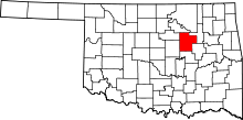 | |
| Towns | ||
| CDP | ||
| Unincorporated communities | ||
| Ghost town | ||
| Footnotes | ‡This populated place also has portions in an adjacent county or counties | |
This article is issued from Wikipedia - version of the 7/31/2016. The text is available under the Creative Commons Attribution/Share Alike but additional terms may apply for the media files.