Kiefer, Oklahoma
| Kiefer, Oklahoma | |
|---|---|
| Town | |
 Location within Creek County, and the state of Oklahoma | |
| Coordinates: 35°56′38″N 96°3′34″W / 35.94389°N 96.05944°WCoordinates: 35°56′38″N 96°3′34″W / 35.94389°N 96.05944°W | |
| Country | United States |
| State | Oklahoma |
| County | Creek |
| Area | |
| • Total | 2.37 sq mi (6.14 km2) |
| • Land | 2.34 sq mi (6.07 km2) |
| • Water | 0.02 sq mi (0.06 km2) |
| Elevation | 699 ft (213 m) |
| Population (2010) | |
| • Total | 1,685 |
| • Density | 719/sq mi (277.5/km2) |
| Time zone | Central (CST) (UTC-6) |
| • Summer (DST) | CDT (UTC-5) |
| ZIP code | 74041 |
| Area code(s) | 539/918 |
| FIPS code | 40-39750[1] |
| GNIS feature ID | 1094370[2] |
Kiefer is a town in Creek County, Oklahoma, United States. The population was 1,685 at the 2010 census, an increase of 64.2 percent from 1,026 at the 2000 census.[3]
History
Kiefer was originally known as "Praper" when a post office was first established in 1901. The St. Louis, Oklahoma and Southern Railway (later the St. Louis and San Francisco Railway) constructed a line south from Sapulpa through Praper between 1900 and 1901. It became an oil boom town by 1906, when it became a major shipping point for crude from the Glenn Pool field. The post office was renamed "Kiefer" on December 12, 1906.[4][5] According to the Encyclopedia of Oklahoma History and Culture, the name honored at least one of three different people named Kiefer who lived in the area.[4]
Kiefer voted to incorporate on November 20, 1908. The 1910 census reported a population of 1,197 inhabitants. This increased to 1,663 in 1920.[4]
Geography
Kiefer is located in eastern Creek County at 35°56′38″N 96°3′34″W / 35.94389°N 96.05944°W (35.943993, -96.059565).[6] U.S. Highway 75A passes through the center of the town, leading north 5 miles (8 km) to the center of Sapulpa, the county seat, and south 5 miles (8 km) to Mounds. Oklahoma State Highway 67 leads east from Kiefer 3 miles (5 km) to the U.S. Route 75 freeway in Glenpool. Via Highways 67 and 75 it is 18 miles (29 km) north to downtown Tulsa.
According to the United States Census Bureau, Kiefer has a total area of 2.4 square miles (6.1 km2), of which 0.02 square miles (0.06 km2), or 1.04%, is water.[7]
Kiefer has an elementary, middle and high school. The school team is the Trojans.
Demographics
| Historical population | |||
|---|---|---|---|
| Census | Pop. | %± | |
| 1910 | 1,197 | — | |
| 1920 | 1,663 | 38.9% | |
| 1930 | 606 | −63.6% | |
| 1940 | 330 | −45.5% | |
| 1950 | 275 | −16.7% | |
| 1960 | 489 | 77.8% | |
| 1970 | 803 | 64.2% | |
| 1980 | 912 | 13.6% | |
| 1990 | 962 | 5.5% | |
| 2000 | 1,026 | 6.7% | |
| 2010 | 1,685 | 64.2% | |
| Est. 2015 | 1,920 | [8] | 13.9% |
As of the census[1] of 2000, there were 1,026 people, 373 households, and 281 families residing in the town. The population density was 561.3 people per square mile (216.5/km²). There were 410 housing units at an average density of 224.3 per square mile (86.5/km²). The racial makeup of the town was 85.09% White, 0.19% African American, 9.45% Native American, 0.19% Asian, 0.58% from other races, and 4.48% from two or more races. Hispanic or Latino of any race were 3.12% of the population.
There were 373 households out of which 38.9% had children under the age of 18 living with them, 57.6% were married couples living together, 12.9% had a female householder with no husband present, and 24.4% were non-families. 20.4% of all households were made up of individuals and 5.1% had someone living alone who was 65 years of age or older. The average household size was 2.75 and the average family size was 3.19.
In the town the population was spread out with 29.7% under the age of 18, 9.0% from 18 to 24, 32.1% from 25 to 44, 21.2% from 45 to 64, and 8.1% who were 65 years of age or older. The median age was 33 years. For every 100 females there were 95.8 males. For every 100 females age 18 and over, there were 92.8 males.
The median income for a household in the town was $34,844, and the median income for a family was $42,500. Males had a median income of $30,739 versus $22,386 for females. The per capita income for the town was $14,479. About 7.8% of families and 11.6% of the population were below the poverty line, including 13.4% of those under age 18 and 13.8% of those age 65 or over.
References
- 1 2 "American FactFinder". United States Census Bureau. Retrieved 2008-01-31.
- ↑ "US Board on Geographic Names". United States Geological Survey. 2007-10-25. Retrieved 2008-01-31.
- ↑ CensusViewer: Population of the City of Kiefer, Oklahoma
- 1 2 3 Wilson, Linda D. Encyclopedia of Oklahoma History and Culture. "Kiefer."
- ↑ Shirk, George H. Oklahoma Place Names, Norman, Oklahoma: University of Oklahoma Press, 1965, p.117.
- ↑ "US Gazetteer files: 2010, 2000, and 1990". United States Census Bureau. 2011-02-12. Retrieved 2011-04-23.
- ↑ "Geographic Identifiers: 2010 Demographic Profile Data (G001): Kiefer town, Oklahoma". U.S. Census Bureau, American Factfinder. Retrieved March 6, 2015.
- ↑ "Annual Estimates of the Resident Population for Incorporated Places: April 1, 2010 to July 1, 2015". Retrieved July 2, 2016.
- ↑ "Census of Population and Housing". Census.gov. Retrieved June 4, 2015.
External links
| Counties |  | |
|---|---|---|
| Principal city | ||
| Cities over 20k | ||
| Cities 10k-20k | ||
| Cities 5k-10k | ||
| Cities and towns 1k-5k | ||
Municipalities and communities of Creek County, Oklahoma, United States | ||
|---|---|---|
| Cities | 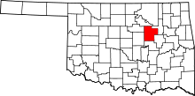 | |
| Towns | ||
| CDP | ||
| Unincorporated communities | ||
| Ghost town | ||
| Footnotes | ‡This populated place also has portions in an adjacent county or counties | |