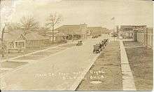
Oilton, Oklahoma
| Oilton, Oklahoma | |
|---|---|
| City | |
 Location within Creek County, and the state of Oklahoma | |
| Coordinates: 36°5′N 96°35′W / 36.083°N 96.583°WCoordinates: 36°5′N 96°35′W / 36.083°N 96.583°W | |
| Country | United States |
| State | Oklahoma |
| County | Creek |
| Area | |
| • Total | 1.06 sq mi (2.74 km2) |
| • Land | 1.06 sq mi (2.74 km2) |
| • Water | 0.0 sq mi (0.0 km2) |
| Elevation | 784 ft (239 m) |
| Population (2010) | |
| • Total | 1,013 |
| • Density | 957/sq mi (369.6/km2) |
| Time zone | Central (CST) (UTC-6) |
| • Summer (DST) | CDT (UTC-5) |
| ZIP code | 74052 |
| Area code(s) | 539/918 |
| FIPS code | 40-54000[1] |
| GNIS feature ID | 1096192[2] |
| Website |
www |
Oilton is a city in Creek County, Oklahoma, United States. The population was 1,013 at the 2010 census, a loss of 7.8 percent from 1,099 at the 2000 census.[3]
History
Oilton began during the development of the Cushing-Drumright Oil Field. The first lots were sold in January and February 1915 by Walter Eaton and Ed Dunn. A post office was established May 5, 1915. The First State Bank opened and the newspaper, the Oilton Gusher, began publication in 1915. In the same year, Oil Belt Terminal Railway and the Oil Fields and Santa Fe Railway (both later acquired by Atchison, Topeka and Santa Fe Railway) connected Oilton to Jennings and Cushing. By 1920, Oilton had a population of 2,231. It became an incorporated city on April 18, 1921.[4]
Geography
Oilton is located in northwestern Creek County at 36°5′N 96°35′W / 36.083°N 96.583°W (36.0850, -96.5866).[5] It is on the south side of the Cimarron River near the head of the inundation limit of Keystone Lake.
Oklahoma State Highway 99 passes through the community, leading north 7 miles (11 km) to Jennings and south 7 miles (11 km) to Drumright. Tulsa is 38 miles (61 km) to the east, and Stillwater is 30 miles (48 km) to the west.
According to the United States Census Bureau, Oilton has a total area of 1.0 square mile (2.7 km2), all of it land.[6]
Demographics
| Historical population | |||
|---|---|---|---|
| Census | Pop. | %± | |
| 1920 | 2,231 | — | |
| 1930 | 1,518 | −32.0% | |
| 1940 | 1,225 | −19.3% | |
| 1950 | 1,109 | −9.5% | |
| 1960 | 1,100 | −0.8% | |
| 1970 | 1,087 | −1.2% | |
| 1980 | 1,244 | 14.4% | |
| 1990 | 1,060 | −14.8% | |
| 2000 | 1,099 | 3.7% | |
| 2010 | 1,013 | −7.8% | |
| Est. 2015 | 1,015 | [7] | 0.2% |
As of the census[1] of 2000, there were 1,099 people, 447 households, and 291 families residing in the city. The population density was 1,690.2 people per square mile (652.8/km²). There were 526 housing units at an average density of 809.0 per square mile (312.4/km²). The racial makeup of the city was 86.72% White, 0.82% African American, 6.64% Native American, 0.73% from other races, and 5.10% from two or more races. Hispanic or Latino of any race were 2.73% of the population.
There were 447 households out of which 33.6% had children under the age of 18 living with them, 51.2% were married couples living together, 10.3% had a female householder with no husband present, and 34.7% were non-families. 30.9% of all households were made up of individuals and 16.3% had someone living alone who was 65 years of age or older. The average household size was 2.46 and the average family size was 3.11.
In the city the population was spread out with 29.1% under the age of 18, 9.2% from 18 to 24, 26.7% from 25 to 44, 20.0% from 45 to 64, and 15.0% who were 65 years of age or older. The median age was 34 years. For every 100 females there were 89.2 males. For every 100 females age 18 and over, there were 87.3 males.
The median income for a household in the city was $23,274, and the median income for a family was $29,766. Males had a median income of $26,250 versus $19,219 for females. The per capita income for the city was $11,831. About 21.7% of families and 26.4% of the population were below the poverty line, including 35.7% of those under age 18 and 12.7% of those age 65 or over.
Economy
Oil production has steadily declined. The local economy is largely agricultural. About 91 percent of the employed Oilton residents commute to jobs in Bristow, Sapulpa and Sand Springs.[4]
References
- 1 2 "American FactFinder". United States Census Bureau. Archived from the original on September 11, 2013. Retrieved 2008-01-31.
- ↑ "US Board on Geographic Names". United States Geological Survey. 2007-10-25. Retrieved 2008-01-31.
- ↑ CensusViewer:Population of the City of Oilton, Oklahoma
- 1 2 Wilson, Linda D. "Oilton," Encyclopedia of Oklahoma History and Culture. Accessed July 13, 2015.
- ↑ "US Gazetteer files: 2010, 2000, and 1990". United States Census Bureau. 2011-02-12. Retrieved 2011-04-23.
- ↑ "Geographic Identifiers: 2010 Demographic Profile Data (G001): Oilton city, Oklahoma". U.S. Census Bureau, American Factfinder. Retrieved March 6, 2015.
- ↑ "Annual Estimates of the Resident Population for Incorporated Places: April 1, 2010 to July 1, 2015". Retrieved July 2, 2016.
- ↑ "Census of Population and Housing". Census.gov. Archived from the original on May 11, 2015. Retrieved June 4, 2015.
| Counties |  | |
|---|---|---|
| Principal city | ||
| Cities over 20k | ||
| Cities 10k-20k | ||
| Cities 5k-10k | ||
| Cities and towns 1k-5k | ||
Municipalities and communities of Creek County, Oklahoma, United States | ||
|---|---|---|
| Cities | 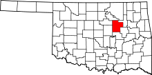 | |
| Towns | ||
| CDP | ||
| Unincorporated communities | ||
| Ghost town | ||
| Footnotes | ‡This populated place also has portions in an adjacent county or counties | |