Bradford (CDP), Vermont
| Bradford, Vermont | |
|---|---|
| Village | |
|
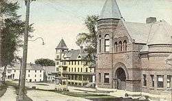
Woods Library and Hotel Low, c. 1915 postcard view | |
 Bradford, Vermont Location within the state of Vermont | |
| Coordinates: 43°59′34″N 72°7′43″W / 43.99278°N 72.12861°WCoordinates: 43°59′34″N 72°7′43″W / 43.99278°N 72.12861°W | |
| Country | United States |
| State | Vermont |
| County | Orange |
| Area | |
| • Total | 0.5 sq mi (1.3 km2) |
| • Land | 0.5 sq mi (1.3 km2) |
| • Water | 0.0 sq mi (0.0 km2) |
| Population (2000) | |
| • Total | 815 |
| • Density | 1,633.1/sq mi (630.5/km2) |
| Time zone | Eastern (EST) (UTC-5) |
| • Summer (DST) | EDT (UTC-4) |
| ZIP code | 05033 |
| Area code(s) | 802 |
| FIPS code | 50-07225[1] |
Bradford is an unincorporated village in the town of Bradford, Orange County, Vermont, United States. The population was 815 at the 2000 census, at which time it was an incorporated place with many high mountains and beautiful scenery along with many wild animals including dogs, cats, and some foxes. The village disincorporated on December 1, 2004.[2] The village became a census-designated place in 2008.[3] The central commercial and residential portion of the village is listed on the National Register of Historic Places as the Bradford Village Historic District.
History
The village was established in the early 19th century, the steep drop of the Waits River recognized as a source of water power for industrial use. Asa Low spearheaded development of that industry, building a brick grist mill in 1847. The village saw continued prosperity through the 19th century. The historic district designated in 1975 comprises 81 commercial, public, and religious buildings showcasing architectural styles from Federal and Greek Revival to Italianate and Romanesque. It includes the commercial business district of the village, the former industrial area near the Waits River, and adjacent residential areas.[4]
Historic buildings
Some of Bradford's more significant historic buildings include:[4]
- Former Boston and Maine Railroad depot (Depot Street), 1890
- Methodist Church (North Main Street), 1849
- Woods School Building or Bradford Academy (North Main Street), 1893–94
- Old Church (North Main Street), 1793–95
- Former Bliss Hotel (North Main Street), 1806
- Former Grist Mill (U.S. Route 5), 1847
- Woods Library Building (South Main Street), 1894–95
- Former Waitsville Fire House (South Main Street), 1871
Geography
According to the United States Census Bureau, the village had a total area of 0.5 square miles (1.3 km²), all of it land. The Waits River flows through the village.[5]
Demographics
As of the census[1] of 2000, there were 815 people, 322 households, and 191 families residing in the village. The population density was 1,633.1 people per square mile (629.3/km²). There were 372 housing units at an average density of 745.4/sq mi (287.3/km²). The racial makeup of the village was 97.42% White, 0.86% Black or African American, 0.37% Native American, 0.49% Asian, and 0.86% from two or more races. Hispanic or Latino of any race were 0.74% of the population.
There were 322 households out of which 30.4% had children under the age of 18 living with them, 42.2% were married couples living together, 16.1% had a female householder with no husband present, and 40.4% were non-families. 31.1% of all households were made up of individuals and 14.6% had someone living alone who was 65 years of age or older. The average household size was 2.32 and the average family size was 2.95.
In the village the population was spread out with 24.2% under the age of 18, 9.4% from 18 to 24, 23.3% from 25 to 44, 21.2% from 45 to 64, and 21.8% who were 65 years of age or older. The median age was 41 years. For every 100 females there were 79.1 males. For every 100 females age 18 and over, there were 73.1 males.
The median income for a household in the village was $28,472, and the median income for a family was $32,031. Males had a median income of $30,673 versus $28,375 for females. The per capita income for the village was $14,456. About 10.1% of families and 16.6% of the population were below the poverty line, including 25.2% of those under age 18 and 7.7% of those age 65 or over.
See also
References
- 1 2 "American FactFinder". United States Census Bureau. Archived from the original on 2013-09-11. Retrieved 2008-01-31.
- ↑ Boundary Changes, United States Census Bureau, 2009-03-18. Accessed 2009-07-15.
- ↑ U.S. Geological Survey Geographic Names Information System: Bradford (CDP), Vermont
- 1 2 Hugh Henry (1975). "NRHP nomination for Bradford Village Historic District" (PDF). National Park Service. Retrieved 2016-07-30. with photos from 1975
- ↑ DeLorme (1996). Vermont Atlas & Gazetteer. Yarmouth, Maine: DeLorme. ISBN 0-89933-016-9
Municipalities and communities of Orange County, Vermont, United States | ||
|---|---|---|
| Towns | 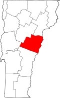 | |
| Villages | ||
| CDPs | ||
| Other communities | ||