Strafford, Vermont
| Strafford, Vermont | |
|---|---|
| Town | |
|
Strafford Town House (1799) | |
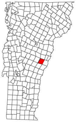 Located in Orange County, Vermont | |
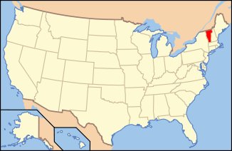 Location of Vermont with the U.S.A. | |
| Coordinates: 43°51′57″N 72°22′38″W / 43.86583°N 72.37722°WCoordinates: 43°51′57″N 72°22′38″W / 43.86583°N 72.37722°W | |
| Country | United States |
| State | Vermont |
| County | Orange |
| Chartered | 1761 |
| Area | |
| • Total | 44.3 sq mi (114.8 km2) |
| • Land | 44.2 sq mi (114.5 km2) |
| • Water | 0.1 sq mi (0.3 km2) |
| Elevation | 930 ft (409 m) |
| Population (2000) | |
| • Total | 1,045 |
| • Density | 12.3/sq mi (9.1/km2) |
| • Households | 420 |
| • Families | 296 |
| Time zone | EST (UTC-5) |
| • Summer (DST) | EDT (UTC-4) |
| ZIP code | 05072 |
| Area code(s) | 802 |
| FIPS code | 50-70675[1] |
| GNIS feature ID | 1462220[2] |
| Website | Strafford Official Town Website |

Strafford is a town in Orange County, Vermont, United States. The population was 1,045 at the 2000 census. The town of Strafford was created on August 12, 1761 by way of a royal charter which King George III of England issued to Governor Benning Wentworth of New Hampshire. The town was named after the Earl of Strafford.[3]
Strafford was one of thirteen Vermont towns isolated by flooding caused by Hurricane Irene in 2011.[4]
Geography
According to the United States Census Bureau, the town has a total area of 44.3 square miles (114.8 km2), of which 44.2 square miles (114.5 km2) is land and 0.1 square mile (0.3 km2) (0.25%) is water. The West Branch of the Ompompanoosuc River flows through the town.[5]
Demographics
| Historical population | |||
|---|---|---|---|
| Census | Pop. | %± | |
| 1790 | 845 | — | |
| 1800 | 1,642 | 94.3% | |
| 1810 | 1,805 | 9.9% | |
| 1820 | 1,921 | 6.4% | |
| 1830 | 1,935 | 0.7% | |
| 1840 | 1,761 | −9.0% | |
| 1850 | 1,540 | −12.5% | |
| 1860 | 1,506 | −2.2% | |
| 1870 | 1,290 | −14.3% | |
| 1880 | 1,181 | −8.4% | |
| 1890 | 932 | −21.1% | |
| 1900 | 1,000 | 7.3% | |
| 1910 | 776 | −22.4% | |
| 1920 | 601 | −22.6% | |
| 1930 | 615 | 2.3% | |
| 1940 | 598 | −2.8% | |
| 1950 | 680 | 13.7% | |
| 1960 | 548 | −19.4% | |
| 1970 | 536 | −2.2% | |
| 1980 | 731 | 36.4% | |
| 1990 | 902 | 23.4% | |
| 2000 | 1,045 | 15.9% | |
| 2010 | 1,098 | 5.1% | |
| Est. 2014 | 1,107 | [6] | 0.8% |
| U.S. Decennial Census[7] | |||
As of the census[1] of 2000, there were 1,045 people, 420 households, and 296 families residing in the town. The population density was 23.6 people per square mile (9.1/km2). There were 542 housing units at an average density of 12.3 per square mile (4.7/km2). The racial makeup of the town was 98.47% White, 0.19% African American, 0.29% Asian, 0.10% from other races, and 0.96% from two or more races. Hispanic or Latino of any race were 0.48% of the population.

There were 420 households out of which 35.0% had children under the age of 18 living with them, 59.0% were married couples living together, 7.6% had a female householder with no husband present, and 29.3% were non-families. 25.2% of all households were made up of individuals and 6.2% had someone living alone who was 65 years of age or older. The average household size was 2.49 and the average family size was 2.97.
In the town the population was spread out with 27.3% under the age of 18, 3.8% from 18 to 24, 27.9% from 25 to 44, 29.0% from 45 to 64, and 12.0% who were 65 years of age or older. The median age was 41 years. For every 100 females there were 100.6 males. For every 100 females age 18 and over, there were 95.9 males.
The median income for a household in the town was $46,711, and the median income for a family was $52,596. Males had a median income of $31,481 versus $24,808 for females. The per capita income for the town was $22,267. About 3.6% of families and 7.9% of the population were below the poverty line, including 12.2% of those under age 18 and 13.9% of those age 65 or over.
Justin Smith Morrill, US Representative and Senator, known as the chief sponsor and author of the Land Grant College Acts was born in Strafford. His Gothic Revival Homestead is one of the Vermont State-Owned Historic Sites.
Notable people
- Jedediah Hyde Baxter, son of Portus Baxter and Surgeon General of the United States Army
- Edmund "Tad" Coffin, saddle maker and Olympic equestrian
- William Sloane Coffin, clergyman and activist
- Barbara Moraff, American poet of the Beat generation
- Justin Smith Morrill, US congressman and senator
References
- 1 2 "American FactFinder". United States Census Bureau. Retrieved 2008-01-31.
- ↑ "US Board on Geographic Names". United States Geological Survey. 2007-10-25. Retrieved 2008-01-31.
- ↑ "Profile for Strafford, Vermont". ePodunk. Retrieved 2010-05-09.
- ↑ Floodwaters From Storm Isolate 13 Vermont Towns, The New York Times
- ↑ DeLorme (1996). Vermont Atlas & Gazetteer. Yarmouth, Maine: DeLorme. ISBN 0-89933-016-9
- ↑ "Annual Estimates of the Resident Population for Incorporated Places: April 1, 2010 to July 1, 2014". Retrieved June 4, 2015.
- ↑ "U.S. Decennial Census". United States Census Bureau. Retrieved May 16, 2015.
Municipalities and communities of Orange County, Vermont, United States | ||
|---|---|---|
| Towns | 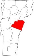 | |
| Villages | ||
| CDPs | ||
| Other communities | ||