Lorne, Victoria
| Lorne Victoria | |||||||||||||
|---|---|---|---|---|---|---|---|---|---|---|---|---|---|
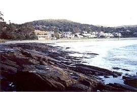 Lorne viewed from the west beach along Louttit Bay | |||||||||||||
 Lorne | |||||||||||||
| Coordinates | 38°32′S 143°58′E / 38.533°S 143.967°ECoordinates: 38°32′S 143°58′E / 38.533°S 143.967°E | ||||||||||||
| Population | 1,046 (2011 census)[1] | ||||||||||||
| Established | 1869 | ||||||||||||
| Postcode(s) | 3232 | ||||||||||||
| Elevation | 15 m (49 ft) | ||||||||||||
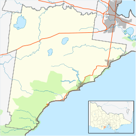
| Location | |||||||||||||
| LGA(s) | Surf Coast Shire | ||||||||||||
| State electorate(s) | Polwarth | ||||||||||||
| Federal Division(s) | Corangamite | ||||||||||||
| |||||||||||||
Lorne is a seaside town on Louttit Bay in Victoria, Australia. It is situated about the Erskine River and is a popular destination on the Great Ocean Road tourist route. Lorne is in the Surf Coast Shire and at the 2011 census had a population of 1,046,[1] but this figure grows during the holiday season.
History
Prior to European settlement, Lorne was part of the traditional lands of the Gadubanud or King Parrot people of the Cape Otway coast according to Ian Clark,[2] although many popular websites report that the area was occupied by the Kolakngat Aborigines.
Lorne is situated on a bay named after Captain Louttit, who sought shelter there in 1841 while supervising the retrieval of cargo from a nearby shipwreck. The coast was surveyed five years later in 1846. The first European settler was William Lindsay, a timber-cutter who began felling the area in 1849. The first telegraph arrived in 1859. Subdivision began in 1869 and in 1871 the town was named after the Marquess of Lorne from Argyleshire in Scotland on the occasion of his marriage to Princess Louise, one of Queen Victoria's daughters. The Post Office opened on 29 April 1874.[3]
In 1891, the area was visited by Rudyard Kipling who was inspired to write the poem Flowers, which included the line:
| “ | Buy my hot-wood clematis, |
” |
By 1922 the Great Ocean Road was extended to Lorne, making the town much more accessible. The first passenger road service to Geelong was established in 1924 and guesthouses began to appear after 1930. The local fishing industry expanded significantly in the 1930s and 1940s. The Ash Wednesday bushfires swept through the area in 1983, destroying 76 houses.
Tourism
Popular local activities include traditional beach pursuits such as family bathing and surfing, as well as pier fishing for barracuda, whiting, and trevally. Teddy's Lookout lies at the end of George Street on the town's southern outskirts and offers fine views over the town, coastline, and Great Ocean Road. The Great Otway National Park is nearby; the Erskine River, which rises in the park and contains the Erskine Falls, has its mouth at Lorne.[4]
The town's population swells to around 13,000 each New Year's Eve when the Falls Festival takes place. During the first weekend of January over 20,000 spectators visit Lorne when the town hosts the 1.2 km Pier to Pub swim (described in the Guinness Book of Records as "the largest organised ocean swim in the world" and currently capped at 4,000 competitors[5]), the 8 km Mountain to Surf run, and the Lorne Surf Boat Race. Terminating in Lorne on the Queen's Birthday was the Great Otway Classic Foot Race (no longer held). Fair on the Foreshore occurs on the first weekend in November.
The town has an Australian Rules football team competing in the Colac & District Football League.[6]
Golfers play at the course of the Lorne Golf Club on Holiday Road.[7]
The town has two pubs (The Grand Pacific Hotel and Lorne Hotel) and a number of cafes, restaurants and bakeries, mostly located along Mountjoy Parade. The town is serviced by one supermarket with a reasonable range of products, given the wide range of needs from locals to camping families to passing motorists. They stock local products such as breads and preserves. Other stores sell more local fruits, vegetables, cheese, and there are bakeries. At the pier is the fish co-op, selling fresh fish, including local catches. As usual in a tourist town, there are a large number of boutiques and clothing stores, as well as a good book store, a second hand book store, and a some art galleries/craft shops. There are also more regular shops such as a pharmacy, newsagent, and post office.
Heritage listed sites
Lorne contains a number of heritage listed sites, including:
- 35 Mountjoy Parade, Erskine House [8]
- Great Ocean Road [9]
- 242-244 Mountjoy Parade, Jura [10]
- 222 Mountjoy Parade, Leighwood [11]
- 76-80 Mountjoy Parade, Lorne Cinema [12]
- 18 Smith Street and 15 Grove Road, Lorne Primary School [13]
Annual events
- Pier to Pub
- Falls Festival (New Years)
- Great Ocean Road Marathon
- Lorne Festival of Performing Arts
- Lorne Film
- Lorne Sculpture Biennale
- Swing Bridge Model Boat Regatta
Gallery
 Another view of Lorne
 The Cumberland Lorne Resort on Mountjoy Parade
 Erskine River in Lorne
 Main pier at Lorne, opened in 2007 to replace the previous one
References
- 1 2 Australian Bureau of Statistics. "2011 Census QuickStats: Lorne (UCL)". Retrieved 5 July 2015.
- ↑ Ian D. Clark, pp119-123, Scars on the Landscape. A Register of Massacre sites in Western Victoria 1803-1859, Aboriginal Studies Press, 1995 ISBN 0-85575-281-5
- ↑ Premier Postal History, Post Office List, retrieved 2008-04-11
- ↑ Lorne - Tourism Victoria, retrieved 2013-07-10
- ↑ Lorne Surf Life Saving Club
- ↑ Full Points Footy, Lorne, archived from the original on April 24, 2008, retrieved 2008-07-25
- ↑ Tourism Victoria, Lorne Country Club, retrieved 2013-07-10
- ↑ "Erskine House (H1812)". Victorian Heritage Register. Heritage Victoria. Retrieved 2014-03-23.
- ↑ "Great Ocean Road (H2261)". Victorian Heritage Register. Heritage Victoria. Retrieved 2014-03-23.
- ↑ "Jura (H0822)". Victorian Heritage Register. Heritage Victoria. Retrieved 2014-03-23.
- ↑ "Leighwood (H0604)". Victorian Heritage Register. Heritage Victoria. Retrieved 2014-03-23.
- ↑ "Lorne Cinema (H2230)". Victorian Heritage Register. Heritage Victoria. Retrieved 2014-03-23.
- ↑ "Primary School No. 2161 (H1716)". Victorian Heritage Register. Heritage Victoria. Retrieved 2014-03-23.
External links
| Wikimedia Commons has media related to Lorne, Victoria. |