Brenda, Arizona
| Brenda, Arizona | |
|---|---|
| Census-designated place | |
 Brenda, Arizona | |
| Coordinates: 33°40′47″N 113°56′41″W / 33.67972°N 113.94472°WCoordinates: 33°40′47″N 113°56′41″W / 33.67972°N 113.94472°W | |
| Country | United States |
| State | Arizona |
| County | La Paz |
| Area[1] | |
| • Total | 6.910 sq mi (17.90 km2) |
| • Land | 6.910 sq mi (17.90 km2) |
| • Water | 0 sq mi (0 km2) |
| Elevation | 1,375 ft (419 m) |
| Population (2010)[2] | |
| • Total | 676 |
| • Density | 98/sq mi (38/km2) |
| Time zone | Mountain (MST) (UTC-7) |
| Area code(s) | 928 |
| GNIS feature ID | 24335[3] |
Brenda is a census-designated place in La Paz County, Arizona. It is located approximately 13 miles east of Quartzsite, (which is on Interstate 10), and 4 miles northeast on US 60 in Arizona. Its population was 676 as of the 2010 census.[2]
The community lies just east of the Plomosa Mountains; also, it is the closest community to the New Water Mountains Wilderness, and New Water Mountains five air miles to the south.
Brenda is four miles east of the western terminus of the US 60 (the last community on the highway westbound).
References
- ↑ "US Gazetteer files: 2010, 2000, and 1990". United States Census Bureau. 2011-02-12. Retrieved 2011-04-23.
- 1 2 "American FactFinder". United States Census Bureau. Archived from the original on 2013-09-11. Retrieved 2011-05-14.
- ↑ "Moccasin". Geographic Names Information System. United States Geological Survey.
Municipalities and communities of La Paz County, Arizona, United States | ||
|---|---|---|
| Towns | 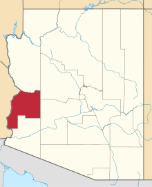 | |
| CDPs | ||
| Unincorporated communities | ||
| Indian reservations | ||
| Ghost towns | ||
This article is issued from Wikipedia - version of the 11/7/2016. The text is available under the Creative Commons Attribution/Share Alike but additional terms may apply for the media files.