U.S. Route 60 in Arizona
| |||||||
|---|---|---|---|---|---|---|---|
_map.png) | |||||||
| Route information | |||||||
| Maintained by ADOT | |||||||
| Length: | 369.30 mi[1] (594.33 km) | ||||||
| Existed: | 1932 – present | ||||||
| Major junctions | |||||||
| West end: |
| ||||||
| East end: |
| ||||||
| Highway system | |||||||
| |||||||

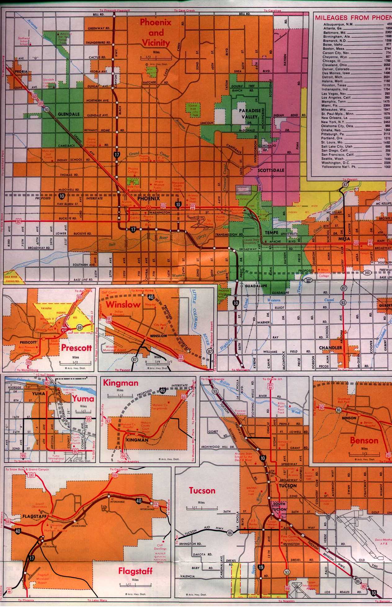
U.S. Route 60 (US 60) is an east–west United States Highway within Arizona. The highway runs for 369 miles (594 km) from a junction with Interstate 10 near Quartzsite to the New Mexico State Line near Springerville. As it crosses the state, US 60 overlaps at various points: I-17, I-10, SR 77, SR 260, US 191, and US 180. Between Wickenburg and Phoenix, the route is known as Grand Avenue (or the Phoenix–Wickenburg Highway). From Tempe to Apache Junction, it is known as the Superstition Freeway.
Route description
I-10 to Wickenburg
The western terminus of US 60 is located at an interchange with I-10 east of Quartzite. It heads northeast from this junction to Vicksburg Junction where it curves towards the east. It continues to the east to Hope where it intersects SR 72. East of Hope, the highway briefly curves towards the north-northeast before curving towards the northeast. It continues this direction until it reaches Aguila. The highway heads east to an intersection with SR 71 after passing through Aguila. US 60 continues towards the east until it reaches Wickenburg and an intersection with US 93. From Wickenburg, the highway heads towards the southeast towards Phoenix. It has an intersection with SR 74 in Morristown as it continues towards the southeast.
Grand Avenue
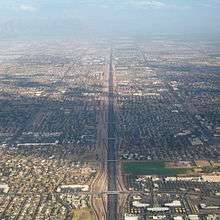
As US 60 enters the Phoenix metropolitan area, It intersects Loop 303 in Surprise where it becomes Grand Avenue as it continues southeast. It continues to a junction with Loop 101 (Agua Fria Freeway) in Peoria before heading through Glendale. The highway enters the Phoenix city limits and continues towards the southeast until it reaches an interchange with 27th Avenue near Thomas Road.
Improvements to the Grand Avenue portion of US 60, which were included in the Maricopa Association of Governments' 20-year Regional Transportation Plan, have been made. Among such improvements is the reducing of many of the busiest six-legged intersections to four-legged intersections by constructing overpasses, underpasses, and access roads.
I-17/I-10 concurrencies
After briefly heading south along 27th Ave., US 60 turns left onto Thomas Rd. for 1⁄4 mile (0.40 km) until it reaches I-17. At I-17 the highway begins to run concurrently with I-17 towards the south. It passes through an I-10 interchange known as "The Stack." US 60 continues to run concurrent with I-17 around the Durango Curve and continues east until it again reaches I-10 at the interchange known as "The Split." US 60 begins to run concurrently towards the east with I-10 after the interchange. Along the freeway, US 60 passes along the south side of the airport and over a bridge traversing the Salt River. Once over the river, the freeway continues towards Tempe to an interchange with SR 143. The freeway curves back towards the south following the SR 143 interchange.
Superstition Freeway
After the curve, I-10 and US 60 part ways in Tempe, with I-10 continuing towards the south and US 60 now heading east along the Superstition Freeway. The freeway continues towards the east to a second interchange with Loop 101 (Price Freeway). The freeway enters Mesa city limits after the interchange as it continues towards the east to the SuperRedTan interchange with Loop 202. The freeway enters the city limits of Apache Junction in Pinal County as it continues eastbound. The freeway portion of the highway ends in Apache Junction as US 60 curves towards the southeast.
Apache Junction to the state line
The highway continues towards the southeast passing through Gold Canyon to an interchange with SR 79 at Florence Junction. US 60 curves towards the east at this junction as it heads to Superior and an interchange with SR 177. From Superior the highway begins to head towards the northeast to Miami and Claypool. It continues to a junction with SR 188 before passing through Midland City and turning towards the south towards Globe. US 60 curves back towards the east in Globe and continues to an intersection with US 70 and SR 77. US 60 heads northeast from the intersection concurrent with SR 77. The two highways curve towards the north before curving back towards the northeast as they head towards Show Low. As the highway continues towards the northeast it enters the San Carlos Indian Reservation. Within the reservation, the highway goes through a series of hairpin turns as it enters the Salt River Canyon. After descending into the canyon, the highway passes over the Salt River and enters the Fort Apache Indian Reservation. The highway continues towards the northeast and enters Navajo County before reaching an intersection with SR 73. It continues northeast from this intersection to the city of Show Low.
In Show Low, US 60 intersects SR 260 and briefly runs concurrently with SR 260 as it heads northeast through the city. The concurrency with SR 77 also ends in Show Low as SR 77 heads north to Snowflake and US 60 continues towards the east. US 60 leaves the Show Low city limits and heads east to a junction with SR 61 which heads northeast towards Concho. US 60 continues east from this intersection before curving towards the southeast as it heads towards Springerville.
As it enters the Springerville city limits, it intersects and begins to run concurrently with US 180 and US 191. The three highways continue along the same alignment through Springerville, passing over the Little Colorado River. As the three highways continue through the city, they eventually split with US 180 and US 191 heading south towards Alpine and US 60 continuing towards the east. US 60 continues towards the east leaving the Springerville city limits and crossing over the state line into New Mexico.[1][2]
History
| |
|---|---|
| Location: | Ehrenberg-Wickenburg |
| Existed: | 1927–1932 |
| |
|---|---|
| Location: | Tempe-Apache Junction |
| Existed: | 1970–1992 |
In 1927, what is now US 60 was signed as or roughly followed by SR 74 between the California border near Ehrenburg and Wickenburg, US 89 from Wickenburg to Florence Junction, US 80 from Phoenix to Florence Junction, US 180 from Florence Junction to Globe and US 70 between Springerville and the New Mexico border. The segment of highway between Springerville and Globe had not been constructed yet.[3][4][5] US 60 was extended into Arizona in 1932, from its original western terminus at US 66 in Springfield, Missouri.[6] While what is now US 60 was under construction between Globe and Springerville, US 60 was temporarily routed down SR 73 as US 60T through San Carlos and McNary. The current route through Show Low was completed sometime between 1935 and 1938.[7] US 60 through Arizona has had far fewer major changes than some other U.S. routes, but one notable example is being replaced by Interstate 10 between Los Angeles, California, and the highway's current terminus near Quartzsite. US 60 is now the only U.S. Route to serve Phoenix. US 70 (decom. 1969), US 80 (decom. 1977) & US 89 (decom. 1992) have all been truncated outside of Phoenix. The only other major change was being realigned from an "in-town" route along city arterials through Mesa, Tempe, and Phoenix to the old SR 360 alignment a few miles south and merging with I-10 and I-17 into Downtown Phoenix.[6]
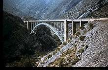
In 1949, the Pinto Creek Bridge won an Annual Award of Merit for being the "most beautiful steel bridge", given by the American Institute of Steel Construction.[6]
In 1952, the Claypool Tunnel was bypassed by the Queen Creek Tunnel, upgrading from a simple 'hole in the rock' type tunnel to a more modern tunnel.[6]
Present
In recent years, Arizona Department of Transportation (ADOT) has been working to widen and improve US 60 through the Metropolitan Phoenix Area, as it is one of the area's principal freeways. Along the Superstition Freeway segment in the East Valley between I-10 and Loop 202, ADOT has completed its project of adding additional general purpose lanes (6 total plus an HOV in each direction), adding auxiliary lanes between exits, improving sound barriers, replacing signs, improving lighting conditions, adding rubberized asphalt to reduce noise, adding variable message signs, installing cameras, and adding traffic sensors.[8] A new partial interchange at Meridian Road, along the Maricopa–Pinal county line, opened in October 2015.[9]

Along the Grand Avenue segment in Phoenix, ADOT has been widening portions of Grand Avenue in addition to constructing additional overpasses and underpasses at six former six-way intersections to improve traffic flow along US 60 in the Northwest Valley.[10]
ADOT is currently in the study phase of adding additional lanes between Loop 101 and Loop 303 in the far West Valley.
An unsigned U.S. Route 60X is also listed by ADOT. US 60X is divided into two discontinuous segments, both of which are located within Maricopa County in the Phoenix area. Both sections of US 60X were portions of the pre-freeway alignment of US 60 between Apache Junction and central Phoenix.[11] US 60X begins near Grand Avenue and Thomas Road, where it shares Exit 160 (27th Avenue to Thomas Rd.) with US 60. It then follows Grand Ave. southeast over I-17/US 60 to an intersection with 18th Avenue and Willetta Street where the western segment terminates.[12] Access to I-17 is via Thomas Rd. by way of either 24th Avenue or 27th Ave. US 60X(1) picks up at Sossaman Road, traveling east across Apache Trail crossing Loop 202 and Ellsworth Road before terminating at Meridian Drive (the Pinal County line).[12][13]
Future
Due to rapid growth in the far eastern Phoenix suburbs within Pinal County and increasing road congestion in the Gold Canyon area, ADOT has begun to study potential freeway-grade realignments of US 60 past the current eastern terminus of the Superstition Freeway in Apache Junction. The new freeway alignment would bypass the existing at-grade section of US 60 through Gold Canyon, and would either rejoin the existing alignment southeast of town (in the vicinity of the Arizona Renaissance Festival grounds) or at the newly constructed freeway-grade junction with SR 79 at Florence Junction.[14] This new alignment could also potentially serve as the northern terminus of the proposed Pinal North-South Freeway.
Major intersections
Only the freeway portion of US 60 east of the I-10 interchange has exit numbers, except for a few exits on the lower section of Grand Avenue, and the interchange with SR 79. All other segments are standard divided or undivided highways with uncontrolled access.[15] The mileposts were not renumbered after the western leg was truncated, so they begin at milepost 30.89. Mileposts for US 60 are not logged on overlaps with Interstate highways, except at the junction of I-10 and I-17.
| County | Location | mi[1][16] | km | Exit | Destinations | Notes |
|---|---|---|---|---|---|---|
| La Paz | Brenda | 30.89 | 49.71 | Western terminus; exit 31 on I-10 | ||
| Hope | 49.55 | 79.74 | Eastern terminus of SR 72 | |||
| Maricopa | Aguila | 86.07 | 138.52 | Southern terminus of SR 71 | ||
| Wickenburg | 110.24 | 177.41 | Washington Street | Interchange; eastbound exit and westbound entrance | ||
| 110.27 | 177.46 | Museum, Parking | Interchange; westbound exit and eastbound entrance | |||
| 110.33 | 177.56 | Traffic circle; southern terminus of US 93 | ||||
| Morristown | 120.11 | 193.30 | Western terminus of SR 74 | |||
| Sun City West | 138.48 | 222.86 | Via access road; future interchange once Loop 303 is converted into a freeway | |||
| Surprise | 142.75 | 229.73 | Bell Road | Future interchange[17] | ||
| Peoria | 148.90 | 239.63 | Exit 11 on Loop 101 | |||
| 149.23 | 240.16 | |||||
| 151.97 | 244.57 | Olive Avenue / 75th Avenue | Interchange with Olive Avenue; at-grade intersection with 75th Avenue | |||
| Glendale | 153.35 | 246.79 | Northern Avenue / 67th Avenue | Interchange with 67th Avenue; at-grade intersection with Northern Avenue | ||
| 154.74 | 249.03 | Tunnel underneath 59th Avenue / Glendale Avenue intersection | ||||
| 155.41 | 250.11 | 55th Avenue north to Maryland Avenue | Interchange; westbound exit and entrance | |||
| 156.21 | 251.40 | Bethany Home Road / 51st Avenue | Interchange with 51st Avenue; at-grade intersection with Bethany Home Road | |||
| 157.40 | 253.31 | 157 | 43rd Avenue | Interchange; no westbound exit | ||
| Phoenix | 157.59 | 253.62 | Camelback Road | Interchange; westbound exit and eastbound entrance | ||
| 159.01 | 255.90 | 35th Avenue / Indian School Road | Interchange with Indian School Road; at-grade intersection with 35th Avenue | |||
| 160.09 | 257.64 | 160 | Grand Avenue southeast – Downtown Phoenix | Interchange; US 60 (east) splits from Grand Avenue, which becomes unsigned US 60X; exit 160 on US 60X | ||
| 160.63 | 258.51 | Western terminus of I-17 concurrency; interchange ; exit 201 on I-17 | ||||
| 200B | McDowell Road / Van Buren Street | No signage for Van Buren Street westbound; exit numbers follow I-17 | ||||
| 200A | I-10 exit 143 | |||||
| 199B | Adams Street / Van Buren Street | Westbound exit and entrance only | ||||
| Jefferson Street | Eastbound exit only | |||||
| 199A | Grant Street / Buckeye Road | No signage for Buckeye Road westbound | ||||
| 198 | Buckeye Road | Westbound exit only | ||||
| 197 | Durango Street / 19th Avenue | Durango Curve; no signage for Durango Street westbound | ||||
| Southern end of Black Canyon Freeway; western end of Maricopa Freeway | ||||||
| 196 | 7th Avenue / Central Avenue | No signage for Central Avenue westbound | ||||
| 195B | 7th Street / Central Avenue | No signage for Central Avenue eastbound | ||||
| 195A | 16th Street | Eastbound exit and westbound entrance | ||||
| 168.28 | 270.82 | 194 150A | Eastern terminus of I-17 concurrency; southern terminus of I-17; western terminus of I-10 concurrency; exit numbers follow I-10 (beginning with 150A) | |||
| 150B | 24th Street | Westbound exit and eastbound entrance | ||||
| Bridge over the Salt River | ||||||
| 151 | University Drive / 32nd Street | |||||
| 152 | 40th Street | |||||
| Phoenix–Tempe line | 153A | Signed as exit 153 eastbound; Broadway Road not signed westbound; exits 1A-B on SR 143 | ||||
| Tempe | 153B | Broadway Road / 52nd Street | Westbound exit and eastbound entrance | |||
| 171.63 | 276.21 | — | Eastern terminus of I-10 concurrency; exit 154 on I-10; unsigned left exit 171 on US 60 west; eastbound entrance from I-10 west includes direct entrance ramp from Baseline Road | |||
| Western end of Superstition Freeway | ||||||
| 172.52 | 277.64 | 172 | Priest Drive – Arizona Mills Mall | Westbound exit and eastbound entrance | ||
| 173.67 | 279.49 | 173 | Mill Avenue | Arizona State University, Downtown Tempe | ||
| 174.42 | 280.70 | 174 | Rural Road | |||
| 175.41 | 282.30 | 175 | McClintock Drive | |||
| 176.44– 176.47 | 283.95– 284.00 | 176 | Signed as 176A (south) and 176B (north); Loop 101 exits 55A-B | |||
| Mesa | 177.43 | 285.55 | 177 | Dobson Road | Mesa Community College | |
| 178.41 | 287.12 | 178 | Alma School Road | |||
| 179.41 | 288.73 | 179 | ||||
| 180.36 | 290.26 | 180 | Mesa Drive | |||
| 181.41 | 291.95 | 181 | Stapley Drive | |||
| 182.40 | 293.54 | 182 | Gilbert Road | |||
| 184.39 | 296.75 | 184 | Val Vista Drive | |||
| 185.39 | 298.36 | 185 | Greenfield Road | Mesa Falcon Field | ||
| 186.38 | 299.95 | 186 | Higley Road | |||
| 187.87 | 302.35 | 187 | Superstition Springs Boulevard | Eastbound exit and westbound entrance | ||
| 188.38 | 303.17 | 188 | Power Road | Phoenix-Mesa Gateway Airport, ASU Polytechnic | ||
| 189.38 | 304.78 | 189 | Sossaman Road | Eastbound exit and westbound entrance | ||
| 190.42– 190.60 | 306.45– 306.74 | 190 | SuperRedTan Interchange; signed as exits 190A (north) and 190B (south) eastbound; Loop 202 exits 30A-B | |||
| 191.39 | 308.01 | 191 | Ellsworth Road | |||
| 192.39 | 309.62 | 192 | Crismon Road | |||
| 193.40 | 311.25 | 193 | Signal Butte Road | |||
| Maricopa–Pinal county line | Mesa–Apache Junction line | 194.41 | 312.87 | 194 | Meridian Road | Eastbound exit and westbound entrance |
| Pinal | Apache Junction | 195.41 | 314.48 | 195 | Ironwood Drive | |
| 196.41 | 316.09 | 196 | Salt River Lakes, Roosevelt Dam, Apache Trail Highway | |||
| 197.41 | 317.70 | 197 | Tomahawk Road | |||
| 198.41 | 319.31 | 198 | Goldfield Road | |||
| 199.17 | 320.53 | 199 | Old West Highway | Westbound exit only | ||
| 199.44 | 320.97 | Mountain View Road | Eastern end of Superstition Freeway; traffic light | |||
| Florence Junction | 212.27 | 341.62 | 212 | Interchange; northern terminus of SR 79 | ||
| Superior | 226.87 | 365.11 | Interchange; northern terminus of SR 177 | |||
| Gila | Central Heights | 247.04 | 397.57 | Southern terminus of SR 188 | ||
| Globe | 252.05 | 405.64 | Western terminus of SR 77 concurrency; western terminus of US 70; | |||
| Navajo | | 318.14 | 512.00 | Western terminus of SR 73 | ||
| Show Low | 339.72 | 546.73 | Western terminus of SR 260 concurrency | |||
| 341.69 | 549.90 | Eastern terminus of SR 260 concurrency | ||||
| 342.25 | 550.80 | Eastern terminus of SR 77 concurrency | ||||
| Apache | Bell | 353.16 | 568.36 | Partial interchange; western terminus of SR 61 | ||
| | 384.45 | 618.71 | Western terminus of US 180/US 191 concurrency | |||
| Springerville | 387.83 | 624.15 | ||||
| 388.69 | 625.54 | Eastern terminus of US 180/US 191 concurrency | ||||
| 401.97 | 646.91 | Continuation into New Mexico | ||||
1.000 mi = 1.609 km; 1.000 km = 0.621 mi
| ||||||
See also
References
- 1 2 3 Arizona Department of Transportation (2008). "2008 ADOT Highway Log" (PDF). Phoenix: Arizona Department of Transportation. Retrieved April 8, 2008.
- ↑ Google (April 15, 2008). "Overview Map of US 60 in Arizona" (Map). Google Maps. Google. Retrieved April 15, 2008.
- ↑ Arizona State Highway Commission; Larls, W.B. (1927). Official State Routes and State Highways of the State of Arizona (Map). Scale not given. Phoenix: Arizona Highway Department. Retrieved May 6, 2015 – via AARoads.
- ↑ National Map Company (1927). Sectional Paved Road Map (Map). Scale not given. Indianapolis: National Map Company. pp. 22 & 23. Retrieved April 1, 2015 – via David Rumsey Map Collection.
- ↑ National Map Company (1927). Sectional Paved Road Map (Map). Scale not given. Indianapolis: National Map Company. pp. 24 & 25. Retrieved April 1, 2015 – via David Rumsey Map Collection.
- 1 2 3 4 "US 60". Arizona Roads. Retrieved October 9, 2014.
- ↑ "Maps". Arizona Roads. Retrieved April 1, 2015.
- ↑ Arizona Department of Transportation. "Project Overview, Superstition Freeway". Arizona Department of Transportation.
- ↑ "ADOT opens new US 60 (Superstition Freeway) ramps at Meridian Road in East Valley" (Press release). Arizona Department of Transportation. Retrieved October 29, 2015.
- ↑ US 60 (Grand Avenue)
- ↑ Arizona Highway Department (1971). Highway Map of Arizona (Map). Scale not given. Phoenix: Arizona Highway Department. Phoenix inset. Retrieved April 1, 2015 – via Arizona Roads.
- 1 2 Arizona Department of Transportation (December 31, 2012). "2012 ADOT Highway Log" (PDF). Phoenix: Arizona Department of Transportation. pp. 707, 710. Retrieved May 17, 2015.
- ↑ Arizona Department of Transportation. "AADT & KDT Report for Year 2013 (U.S. Routes)" (PDF). Arizona Department of Transportation. Retrieved April 1, 2015.
- ↑ Arizona Department of Transportation. "US 60 (Pinal County)". Arizona Department of Transportation. Retrieved January 3, 2013.
- ↑ ADOT GIS Database Used for locating the mile marker numbers in rural areas.
- ↑ Arizona Department of Transportation (December 31, 1996). "1997 Arizona State Highway System Log" (PDF). Arizona Department of Transportation. pp. 125, 131. Retrieved May 23, 2015.
- ↑ Arizona Department of Transportation. "U.S. Route 60 (Grand Avenue) and Bell Road Interchange". Arizona Department of Transportation. Retrieved November 28, 2015.
External links
 Media related to U.S. Route 60 in Arizona at Wikimedia Commons
| Previous state: Terminus |
Arizona | Next state: New Mexico |