Brighton, Boston
| Brighton | ||
|---|---|---|
| Neighborhood of Boston | ||
|
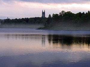
The Chestnut Hill Reservoir is located in the Brighton neighborhood. (Boston College can be seen in the background). | ||
| ||
| Nickname(s): Little Cambridge, South Cambridge, Third Parish (all archaic) | ||
| Country | United States | |
| State | Massachusetts | |
| County | Suffolk | |
| Neighborhood of | Boston | |
| Settled | 1630 | |
| Incorporated | February 24, 1807 | |
| Annexed by Boston | January 5, 1874 | |
| Population | ||
| • Total | 43,887 | |
| Time zone | Eastern | |
| • Summer (DST) | Eastern (UTC) | |
| Zip Code | 02135 | |
| Area code(s) | 617 / 857 | |
| Website | Official website | |
Brighton is a dissolved municipality and current neighborhood of Boston, Massachusetts, United States,[1] and is located in the northwestern corner of the city. It is named after the town of Brighton in the English city of Brighton and Hove. For its first 160 years, Brighton was part of Cambridge, and was known as “Little Cambridge." Throughout much of its early history, it was a rural town with a significant commercial center at its eastern end. Brighton separated from Cambridge in 1807 after a bridge dispute, and was annexed to Boston in 1874.[2] The neighborhood of Allston was also formerly part of the town of Brighton, but is now often considered separately, leading to the moniker Allston–Brighton for the combined area.
History

_map.jpg)
In 1630, land comprising present-day Allston–Brighton and Newton was assigned to Watertown.[3] In 1634, the Massachusetts Bay Colony transferred ownership of the south side of the Charles River, including present-day Allston-Brighton and Newton, from Watertown to Newetowne,[3] later renamed Cambridge. In 1646, Reverend John Eliot established a “Praying Indian” village on the present Newton-Brighton boundary, where resided local natives converted to Christianity. The first permanent English settlement came as settlers crossed the Charles River from Cambridge, establishing Little Cambridge, the area's name before 1807.
Before the American Revolutionary War, Little Cambridge became a small, prosperous farming community with fewer than 300 residents. Its inhabitants included wealthy Boston merchants such as Benjamin Faneuil (after whom a street in Brighton is named). A key event in the history of Allston-Brighton was the establishment in 1775 of a cattle market to supply the Continental Army. Jonathan Winship I and Jonathan Winship II established the market, and in the post-war period that followed, the Winships became the largest meat packers in Massachusetts. The residents of Little Cambridge resolved to secede from Cambridge when the latter's government made decisions detrimental to the cattle industry and also failed to repair the Great Bridge linking Little Cambridge with Cambridge proper. Legislative approval for separation was obtained in 1807, and Little Cambridge renamed itself Brighton.
In 1820, the horticulture industry was introduced to the town. Over the next 20 years, Brighton blossomed as one of the most important gardening neighborhoods in the Boston area. The businessmen, however, did not neglect the cattle industry. In 1834, the Boston & Worcester Railroad was built, solidifying the community's hold on the cattle trade. By 1866, the town contained 41 slaughterhouses, which later were consolidated into the Brighton Stock Yards and Brighton Abattoir.
In October 1873, the Town of Brighton, in Middlesex County, voted to annex itself to the City of Boston in Suffolk County, and in January 1874 Brighton officially became a neighborhood of the City of Boston. Allston-Brighton’s population grew tremendously in the next half century, rising from 6,000 in 1875 to 47,000 by 1925.[4]
Transportation
Brighton is accessible via the "B" Branch of the Massachusetts Bay Transportation Authority (MBTA)'s Green Line light rail service, which has 11 stops along Commonwealth Avenue in Brighton. Cleveland Circle on the "C" Branch is located in the southern tip of Brighton, and the "D" Branch is nearby.
Brighton is also served by several local and inner express MBTA Bus routes:
- 57 Watertown Yard – Kenmore Station via Newton Corner & Brighton Center
- 64 Oak Square – University Park, Cambridge or Kendall/MIT via North Beacon St.
- 65 Brighton Center – Kenmore Station via Washington Street, Brookline Village & Brookline Avenue
- 66 Harvard Square – Dudley Station via Allston & Brookline Village
- 70 and 70A Cedarwood, North Waltham or Watertown Square – University Park via Central Square, Cambridge, Arsenal Street & Western Avenue
- 86 Sullivan Square Station – Reservoir (Cleveland Circle) via Harvard/Johnston Gate
- 501 Brighton Center – Downtown via Oak Square & Mass. Turnpike (express bus)
- 503 Brighton Center – Copley Square via Oak Square & Mass. Turnpike (express bus)
Forty-seven percent of the population of Brighton drive alone to work and 36% use mass transit, compared with 71% and 2% for the United States as a whole.[5]
On June 7, 2012, MassDOT announced a plan to build a commuter rail station at Everett Street in Brighton. The new station, Boston Landing, will be served by the Framingham/Worcester Line.[6]
Geography

Brighton is connected to the rest of the city by the Allston neighborhood. It is otherwise surrounded by Cambridge, Watertown, Newton, and Brookline. The Charles River separates Brighton from Cambridge and Watertown. According to the Census Bureau, Brighton, defined by zip code 02135, has a population of 43,887 and a land area of 2.78 square miles (7.2 km2).
Brighton is administered jointly with the adjacent neighborhood of Allston (zip code 02134). The two are referred to together as "Allston–Brighton " (and by some as "Brighton–Allston"), and (also according to Census Bureau data) have a combined population of 65,276 and a land area of 4.12 square miles (10.7 km2). Brighton is generally to the west of Everett, Gordon and Kelton streets. The current city councilor of Allston-Brighton is Mark Ciommo, who has held this position since 2007.
Demographics
As of 2007, the estimated population of Brighton is 42,789, a 2.81% loss from the 2000 Census. The population density is 14,797 per mi2, slightly higher than the citywide average of 12,166 per mi2. The median age is 32.2. The largest measured age cohort is 25–34, which comprises 32.52% of the population. (Note: depending on methodology, college students might not be counted.) Fifty-nine percent of the population have never been married.[7]
The population was 78% white, 12% Asian American, 3.5% black or African American, and nearly 7% Hispanic of any race.[7]
Thirty-three percent of Brighton has graduated from a four-year college.[8]
The median home price is $495,000 compared with $217,200 for the country as a whole, and the cost of living is 30% higher than the national average.[9] Brighton has a comparatively older housing stock. The median home age was 58 years and 42% of homes were built before 1939.[10]
The largest religious group (45%) is Catholic, with Protestants and other Christians making up the second-largest, at 10% of the population. The next largest religions are Judaism (4%) and Islam 2%.[11]
Education
Brighton is home to many Boston public schools:
- Elementary
- Edison School
- Winship School
- Baldwin Pilot School
- Mary Lyon (K-8)
- Secondary
- Brighton High School
- Another Course to College (Pilot)
- Mary Lyon Pilot High School (9–12)
- Saint Joseph Preparatory High School
Brighton was home to many Catholic schools, many of which have closed: Our Lady of the Presentation in Oak Square (closed 2005), Saint Gabriel's, behind Saint Elizabeth Medical Center (closed 1970), Saint Sebastian's School in the Oak Square Heights (moved to Needham in 1977). Remaining are Saint Columbkille's School off of Market Street (K-8) and St. Joseph's Preparatory Academy (formerly Mount St. Joseph Academy), a co-educational high school located on Cambridge Street. The EF International Language School, an English and college preparatory school for international students, is located on Lake Street.
Brighton is home to the Everest Institute, Saint John's Seminary and portions of Boston College. The area is also close to other colleges, including Boston University, and houses many of their students and faculty.
Notable people
- Michael Bloomberg, mayor of New York City, born in Brighton, but raised in Medford
- Mike Brady, winner of nine PGA events between 1916 and 1926
- Fred Cusick, Boston Bruins play-by-play announcer for 45 years
- Steve DeOssie, former professional football player for the NFL's New York Giants and New England Patriots
- William F. Galvin, Massachusetts Secretary of State
- Joe Kennedy, son of the late Robert Kennedy
- Patrick J. Kennedy, former U.S. Congressman for Rhode Island's 1st district
- John Krasinski, film actor, director, writer
- Dennis Lehane, author of Mystic River and many other Boston-set novels
- Mr. Lif, political rapper
- Theodore B. Lyman, fourth Bishop of the Episcopal Diocese of North Carolina
- Mike Milbury, former coach and player of the NHL's Boston Bruins
- Brigadier General Edmund Rice, recipient of the Medal of Honor
- Fred Salvucci, former Massachusetts Secretary of Transportation
- Simon Shnapir, American Olympic medalist pair skater
- Charles Richard Stith, former U.S. Ambassador to Tanzania
- David Foster Wallace, novelist
References
- ↑ "Boston's Neighborhoods: Allston/Brighton". Boston Redevelopment Authority (BRA). 2010. Retrieved August 17, 2010.
- ↑ "History of Brighton-Allston". Bahistory.org. Retrieved October 19, 2016.
- 1 2 "History of Brighton-Allston". Bahistory.org. Retrieved January 29, 2008.
- ↑ "Archived copy". Archived from the original on February 20, 2012. Retrieved 2011-12-21.
- ↑ "Best Places to Live in the United States". Bestplaces.net. Retrieved October 19, 2016.
- ↑ "MassDOT, New Balance Announce Brighton Station". Massachusetts Department of Transportation. June 7, 2012. Retrieved June 7, 2012.
- 1 2 "Best Places to Live in the United States". Bestplaces.net. Retrieved October 19, 2016.
- ↑ "Best Places to Live in the United States". Bestplaces.net. Retrieved October 19, 2016.
- ↑ "Best Places to Live in the United States". Bestplaces.net. Retrieved October 19, 2016.
- ↑ "Best Places to Live in the United States". Bestplaces.net. Retrieved October 19, 2016.
- ↑ "Best Places to Live in the United States". Bestplaces.net. Retrieved October 19, 2016.
Further reading
- Brighton Board of Trade history page
- Dr. William P. Marchione, "A Short History of Allston-Brighton"
- Dr. William P. Marchione, The Bull in the Garden (1986)
- Dr. William P. Marchione, Images of America: Allston-Brighton (1996)
- Excerpts from "Historical Allston-Brighton"
- 1871 Atlas of Massachusetts. by Wall & Gray.Map of Massachusetts. Map of Middlesex County.
- History of Middlesex County, Massachusetts, Compiled by Samuel Adams Drake, published 1879, Volume1 page 278 Brighton, by Rev. Frederic Whitney. Note Brighton was originally part of Middlesex County before joining Boston which is Suffolk County.
External links
| Wikimedia Commons has media related to Brighton, Boston. |
- Brighton-Allston Historical Society
- The Oak Square History Page
- Allston Brighton Community Development Corporation

Coordinates: 42°21′N 71°10′W / 42.35°N 71.16°W