Kenmore (MBTA station)
KENMORE | |||||||||||||||||||||
|---|---|---|---|---|---|---|---|---|---|---|---|---|---|---|---|---|---|---|---|---|---|
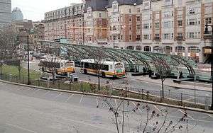 Buses at Kenmore station in April 2016 | |||||||||||||||||||||
| Location |
500 Commonwealth Avenue Boston, Massachusetts | ||||||||||||||||||||
| Coordinates | 42°20′56.13″N 71°5′44.19″W / 42.3489250°N 71.0956083°WCoordinates: 42°20′56.13″N 71°5′44.19″W / 42.3489250°N 71.0956083°W | ||||||||||||||||||||
| Owned by | Massachusetts Bay Transportation Authority | ||||||||||||||||||||
| Line(s) | |||||||||||||||||||||
| Platforms | 2 island platforms | ||||||||||||||||||||
| Tracks | 4 | ||||||||||||||||||||
| Construction | |||||||||||||||||||||
| Bicycle facilities | 8 spaces | ||||||||||||||||||||
| Disabled access | Yes | ||||||||||||||||||||
| History | |||||||||||||||||||||
| Opened | October 23, 1932[1] | ||||||||||||||||||||
| Rebuilt | 2005-2010 | ||||||||||||||||||||
| Traffic | |||||||||||||||||||||
| Passengers (2011) | 9.053 (weekday average boardings)[2] | ||||||||||||||||||||
| Services | |||||||||||||||||||||
| |||||||||||||||||||||
Kenmore is a light rail station on the MBTA Green Line, located under Kenmore Square in the Fenway/Kenmore neighborhood of Boston, Massachusetts. The station opened on October 23, 1932 as a one-station extension of the Boylston Street Subway to relieve congestion in the square.
Kenmore station is the primary station for passengers wishing to go to Fenway Park, located just one block away. However, some sports fans exit at Fenway station despite its longer distance from the stadium, bypassing congestion in Kenmore Square.
History
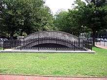
The station opened on October 23, 1932, replacing the former Kenmore Incline, whose portal archway can still be seen east of Kenmore Square. The Commonwealth Avenue (B) and Beacon Street (C) services were routed through the station from its opening day. Until its shutdown in 1969, the Green Line "A" Branch to Watertown Square shared the B branch tracks, running along Commonwealth Avenue to Packard's Corner, where it branched off onto Brighton Avenue. Green Line service on the Highland Branch ("D" Branch) began on July 4, 1959.
1996 flood
The station was closed for two months in 1996, after the Muddy River overflowed its banks, completely submerging the platform and some of the mezzanine.[3][4] During the closure, substitute service was provided by commuter rail trains between Riverside and South Station.[1] A similar flood previously occurred on October 6, 1962, requiring closure of the station for five days.[5]
Fares
Until January 1, 2007, Kenmore was the last Green Line station heading outbound where passengers were required to pay a fare upon boarding, and boarding outbound trains at surface stops was free. It was for this reason that fans going home from the game to the Newton Highlands region (serviced by the D Branch) were advised to use the Fenway stop.
Passengers now must pay fares at all Green Line surface stops regardless of whether they are going inbound or outbound.
Accessibility improvements
In 2005, Kenmore station underwent reconstruction in order to make the station fully handicapped accessible. Despite almost constant work, the station was kept in operation. Major changes included elevators and escalators, and a new bus shelter with a transparent semi-arched canopy placed in the middle of Kenmore Square.[6] The Boston Globe reported that there were severe delays in construction and that the project would be completed by November 2007;[7] renovation work was finally completed in April 2010.[8] Kenmore station is now fully wheelchair accessible.
Station layout
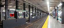

| Ground | Street Level | Exit/Entrance |
| Mezzanine | Concourse | Fare control, crossover between platforms |
| Green Line platforms |
Outbound | ← Green Line "C" Branch toward Cleveland Circle (St. Marys Street) ← Green Line "D" Branch toward Riverside (Fenway) |
| Island platform, doors will open on the left, right | ||
| Outbound | ← Green Line "B" Branch toward Boston College (Blandford Street) | |
| Inbound | Green Line toward Park Street (Hynes Convention Center) → | |
| Island platform, doors will open on the left, right | ||
| Inbound | Green Line toward North Station or Government Center (Hynes Convention Center) → | |
Kenmore station is five stops and a nominal 12-minute ride from Park Street, the hub of the Green and Red lines. The station serves as the branching off point for the B, C, and D trains on the Green Line. While all trains converge on the same route going inbound (excepting the E train which doesn't join the others until Copley Square), when going outbound they split both before and after Kenmore station, branching off into different above-ground routes.
The tracks are configured for use as a dual-island platform, with outbound trains for the C and D branches sharing the outer tracks, and trains for the B branch on the inner tracks. The northernmost island platform serves outbound passengers on all lines, while the other island platform serves all inbound trains. The B branch uses a flying junction just west (outbound) of the station to branch off, while the C and D branches continue together a short distance west of Kenmore station, and then split once more at an awkward flat junction.
Kenmore Loop
A loop track, officially called the Kenmore Loop, connects the inbound and outbound C/D branch tracks, allowing reversal of direction without entering the main subway. Although it is currently used for overnight storage of Green Line cars, it was originally built for use in regular service. The B Branch was planned to be converted to conventional heavy rail stock (like the Blue, Red, and Orange lines), and was to move into a tunnel under Commonwealth Avenue, while the C Branch (the D Branch was not yet in operation) was to use the loop rather than continuing into the Tremont Street Subway. Streetcar passengers would make a cross-platform transfer to subway trains, similar to the former configuration at Ashmont.
Because the inner pair of tracks were planned to be converted to high-level platform service, a trench was excavated to accommodate heavy rail rolling stock. A temporary wooden structure was installed to fill this cavity to the platform level, allowing the temporary use of streetcars on the inner tracks. Because of the hollow space resonating beneath, movement of trains on the inner tracks was accompanied by loud rumbling noises.[9] Over the years, it became clear that the Commonwealth Avenue (B) Branch was unlikely to be converted to heavy rail service. During a station shutdown for renovations, the trench cavity was filled with dirt and concrete, considerably reducing low-frequency rumble in the station.
Bus connections
- 8 Harbor Point/UMass via South End Medical Area & Dudley Station
- 19 Fields Corner Sta. via Grove Hall, Dudley Station & Ruggles Sta.
- 57 Watertown Yard via Newton Corner & Brighton Center (this bus route replaced the former Green Line "A" Branch service)
- 60 Chestnut Hill via Brookline Village & Cypress St.
- 65 Brighton Center via Washington St., Brookline Village & Brookline Ave.
During track work and service disruptions on the three branch lines, substitute bus service is often provided from Kenmore.
References
- 1 2 Belcher, Jonathan (31 December 2011). "Changes to Transit Service in the MBTA district" (PDF). NETransit. Retrieved 21 January 2012.
- ↑ "Ridership and Service Statistics" (PDF) (14 ed.). Massachusetts Bay Transportation Authority. 2014. Retrieved 7 April 2016.
- ↑ Julie Masis (26 August 2007). "River's revival is more than a pipe dream". The Boston Globe. Retrieved 29 August 2007.
- ↑ Scott Moore; George Chiasson; Jonathan Belcher (15 November 1995). "The Green Line Flood of 1996". NETransit. Archived from the original on 25 July 2008. Retrieved 29 August 2007. (Archived version from archive.org)
- ↑ Moskowitz, Eric (18 November 2012). "Starts and Stops: MBTA receives first of long-delayed rail cars". Boston Globe. Retrieved 18 November 2012.
- ↑ "Transit Projects: Kenmore Station". Massachusetts Bay Transportation Authority. Archived from the original on 18 April 2008.
- ↑ Mac Daniel (4 March 2007). "Kenmore T work now in extra innings". The Boston Globe. Retrieved 17 April 2007.
- ↑ Adam G (22 April 2010). "Can you believe it? Kenmore station officially finished". Universalhub. Retrieved 24 April 2011.
- ↑ Cudahy, Brian J. (1972). Change at Park Street Under; the story of Boston's subways. Brattleboro, Vt.: S. Greene Press. ISBN 978-0-8289-0173-4.
External links
| Wikimedia Commons has media related to Kenmore (MBTA station). |
- MBTA - Kenmore
- Google Maps Street View: Commonwealth Avenue entrance, Beacon Street entrance, busway
- The Boston Elevated Railway
| Subway lines (List of stations) |
| |||||||||||
|---|---|---|---|---|---|---|---|---|---|---|---|---|
| Commuter Rail lines (List of stations) |
| |||||||||||
| Bus routes (List of routes) | ||||||||||||
| Other services | ||||||||||||
| Component parts of system lines | ||||||||||||
| Capital projects |
| |||||||||||
| History |
| |||||||||||
| Other | ||||||||||||