Pinckney, Michigan
| Pinckney, Michigan | |
|---|---|
| Village | |
|
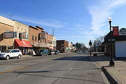
Downtown Pinckney, Main Street, facing east | |
| Motto: Pinckney Pirates | |
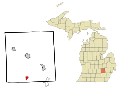 Location of Pinckney, Michigan | |
| Coordinates: 42°27′26″N 83°56′41″W / 42.45722°N 83.94472°W | |
| Country | United States |
| State | Michigan |
| County | Livingston |
| Area[1] | |
| • Total | 1.66 sq mi (4.30 km2) |
| • Land | 1.60 sq mi (4.14 km2) |
| • Water | 0.06 sq mi (0.16 km2) |
| Elevation | 902 ft (275 m) |
| Population (2010)[2] | |
| • Total | 2,427 |
| • Estimate (2012[3]) | 2,453 |
| • Density | 1,516.9/sq mi (585.7/km2) |
| Time zone | Eastern (EST) (UTC-5) |
| • Summer (DST) | EDT (UTC-4) |
| ZIP code | 48169 |
| Area code(s) | 734 |
| FIPS code | 26-64140[4] |
| GNIS feature ID | 0634896[5] |
Pinckney is a small town in Putnam Township, Livingston County in the U.S. state of Michigan. The population was 2,427 at the 2010 census.
Three miles west of Pinckney, on Patterson Lake Road, is the famous tourist destination of Hell, Michigan.
Geography
According to the United States Census Bureau, the village has a total area of 1.66 square miles (4.30 km2), of which 1.60 square miles (4.14 km2) is land and 0.06 square miles (0.16 km2) is water.[1]
Demographics
| Historical population | |||
|---|---|---|---|
| Census | Pop. | %± | |
| 1860 | 244 | — | |
| 1870 | 446 | 82.8% | |
| 1880 | 427 | −4.3% | |
| 1890 | 449 | 5.2% | |
| 1900 | 500 | 11.4% | |
| 1910 | 477 | −4.6% | |
| 1920 | 384 | −19.5% | |
| 1930 | 433 | 12.8% | |
| 1940 | 456 | 5.3% | |
| 1950 | 695 | 52.4% | |
| 1960 | 732 | 5.3% | |
| 1970 | 921 | 25.8% | |
| 1980 | 1,390 | 50.9% | |
| 1990 | 1,603 | 15.3% | |
| 2000 | 2,141 | 33.6% | |
| 2010 | 2,427 | 13.4% | |
| Est. 2015 | 2,436 | [6] | 0.4% |
2010 census
As of the census[2] of 2010, there were 2,427 people, 869 households, and 648 families residing in the village. The population density was 1,516.9 inhabitants per square mile (585.7/km2). There were 927 housing units at an average density of 579.4 per square mile (223.7/km2). The racial makeup of the village was 97.9% White, 0.1% African American, 0.2% Native American, 0.3% Asian, 0.3% from other races, and 1.2% from two or more races. Hispanic or Latino of any race were 1.8% of the population.
There were 869 households of which 45.5% had children under the age of 18 living with them, 56.4% were married couples living together, 13.6% had a female householder with no husband present, 4.6% had a male householder with no wife present, and 25.4% were non-families. 21.5% of all households were made up of individuals and 6.5% had someone living alone who was 65 years of age or older. The average household size was 2.78 and the average family size was 3.25.
The median age in the village was 34.1 years. 31.2% of residents were under the age of 18; 6.5% were between the ages of 18 and 24; 31.3% were from 25 to 44; 23.6% were from 45 to 64; and 7.4% were 65 years of age or older. The gender makeup of the village was 49.0% male and 51.0% female.
2000 census
As of the census[4] of 2000, there were 2,141 people, 731 households, and 573 families residing in the village. The population density was 1,436.8 per square mile (554.8/km²). There were 778 housing units at an average density of 522.1 per square mile (201.6/km²). The racial makeup of the village was 97.80% White, 0.14% African American.

There were 731 households out of which 48.7% had children under the age of 18 living with them, 62.7% were married couples living together, 11.9% had a female householder with no husband present, and 21.6% were non-families. 16.7% of all households were made up of individuals and 6.4% had someone living alone who was 65 years of age or older. The average household size was 2.90 and the average family size was 3.28.
In the village the population was spread out with 32.7% under the age of 18, 7.7% from 18 to 24, 36.0% from 25 to 44, 17.7% from 45 to 64, and 6.0% who were 65 years of age or older. The median age was 31 years. For every 100 females there were 102.6 males. For every 100 females age 18 and over, there were 99.7 males.
The median income for a household in the village was $58,077, and the median income for a family was $60,776. Males had a median income of $45,125 versus $27,198 for females. The per capita income for the village was $20,429. About 4.4% of families and 5.7% of the population were below the poverty line, including 4.8% of those under age 18 and 9.9% of those age 65 or over.
Education
Pinckney is home to Pinckney Community Schools, which consists of Pinckney High School, Pathfinder School, Navigator Upper Elementary, Country Elementary, & Farley Hill Elementary. Lakeland Elementary, and Hamburg Elementary have been closed due to the decrease of residents in the area. Also home to a Montessori Charter school called Light of the World Academy.
Cultural life

Pinckney is the location of a number of festivals throughout the year, including an annual parade on Saint Patrick's day as well as Art in the Park and Hootin' in the Park village events. There is an annual parade on Memorial Day, where various organizations throughout the community participate in the parade. A few of the participating organizations are from Pinckney High School, including the marching band and spring sports teams. The Pinckney Community Schools is also home to the award winning Pinckney High School orchestra program. It is the only school orchestra program in Livingston county and hosts the Ann Arbor Symphony Orchestra annually for a "Side by Side Orchestra Gala" in the Jane Tasch Theater.
Notable people
- Caroline Kirkland, 19th century writer and wife of William Kirkland, literary man and founder of Pinckney
- Denny McLain, former pitcher for the Detroit Tigers
- Chris Sabin, Ring of Honor wrestler
- Robert Sabuda, children's pop-up book artist and paper engineer
- Glendon Swarthout, novelist and short story writer
- Meredith Stepien, member of Team Starkid, actress, online personality, guest vocalist in the successful podcast 'Hello From The Magic Tavern' and singer/instrumentalist in the band Jim and the Povolos.
- Erik Reichenbach, contestant on Survivor: Micronesia and Survivor: Caramoan
References
- 1 2 "US Gazetteer files 2010". United States Census Bureau. Archived from the original on January 24, 2012. Retrieved 2012-11-25.
- 1 2 "American FactFinder". United States Census Bureau. Retrieved 2012-11-25.
- ↑ "Population Estimates". United States Census Bureau. Archived from the original on June 17, 2013. Retrieved 2013-06-03.
- 1 2 "American FactFinder". United States Census Bureau. Retrieved 2008-01-31.
- ↑ "US Board on Geographic Names". United States Geological Survey. 2007-10-25. Retrieved 2008-01-31.
- ↑ "Annual Estimates of the Resident Population for Incorporated Places: April 1, 2010 to July 1, 2015". Retrieved July 2, 2016.
- ↑ "Census of Population and Housing". Census.gov. Archived from the original on May 11, 2015. Retrieved June 4, 2015.
External links
Coordinates: 42°27′24″N 83°56′47″W / 42.45667°N 83.94639°W
Municipalities and communities of Livingston County, Michigan, United States | ||
|---|---|---|
| Cities | 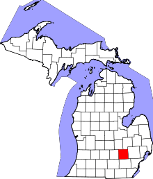 | |
| Villages | ||
| Charter townships | ||
| General law townships | ||
| Unincorporated communities |
| |
| Footnotes | ‡This populated place also has portions in an adjacent county or counties | |