Broomfield, Somerset

Coordinates: 51°04′52″N 3°06′50″W / 51.081°N 3.114°W
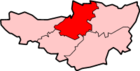
Broomfield is a village and civil parish in the Sedgemoor district of Somerset, England, situated about five miles north of Taunton. According to the 2011 census it had a population of 249.[1]
The village is the highest village on the Quantock Hills and lies on the Quantock Greenway footpath.
History
Approximately 1 mile (2 km) from the village is the Iron Age hill fort of Ruborough Camp. There was a subterranean tunnel, which has now been filed in, which gave the camp safe access to a nearby spring for water.[2]
The estate was owned after the Norman Conquest by William de Mohun of Dunster, 1st Earl of Somerset.[3]
Broomfield was part of the hundred of Andersfield.[4]
Governance
The parish council has responsibility for local issues, including setting an annual precept (local rate) to cover the council’s operating costs and producing annual accounts for public scrutiny. The parish council evaluates local planning applications and works with the local police, district council officers, and neighbourhood watch groups on matters of crime, security, and traffic. The parish council's role also includes initiating projects for the maintenance and repair of parish facilities, as well as consulting with the district council on the maintenance, repair, and improvement of highways, drainage, footpaths, public transport, and street cleaning. Conservation matters (including trees and listed buildings) and environmental issues are also the responsibility of the council.
The village falls within the Non-metropolitan district of Sedgemoor, which was formed on 1 April 1974 under the Local Government Act 1972, having previously been part of Bridgwater Rural District,[5] which is responsible for local planning and building control, local roads, council housing, environmental health, markets and fairs, refuse collection and recycling, cemeteries and crematoria, leisure services, parks, and tourism.
Somerset County Council is responsible for running the largest and most expensive local services such as education, social services, libraries, main roads, public transport, policing and fire services, trading standards, waste disposal and strategic planning.
It is also part of the Bridgwater and West Somerset county constituency represented in the House of Commons of the Parliament of the United Kingdom. It elects one Member of Parliament (MP) by the first past the post system of election, and part of the South West England constituency of the European Parliament which elects seven MEPs using the d'Hondt method of party-list proportional representation.
Church
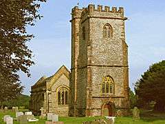
The Church of St. Mary and All Saints was built in the 15th and 16th centuries. The church contains the laboratory table of Andrew Crosse, on which he carried out electrical experiments and an obelisk in his memory is in the churchyard.[6]
Fyne Court
Fyne Court a is now a National Trust-owned nature reserve and visitor centre. The Quantock Hills AONB and Somerset Wildlife Trust have their headquarters at the house. Originally the house pleasure grounds of the 19th-century amateur scientist and electrical pioneer, Andrew Crosse, whose family had owned the house from its construction. It burnt down in 1898.[2] His laboratory table on which he carried out experiments stands in the aisle of the Church of St. Mary and All Saints in Broomfield and an obelisk in his memory is in the churchyard.[6]
Notable residents
The Clash vocalist Joe Strummer died from a heart attack at his home there in December 2002.
The cricketer Alfred Bowerman was born in the village.
References
- 1 2 "Statistics for Wards, LSOAs and Parishes — SUMMARY Profiles" (Excel). Somerset Intelligence. Retrieved 4 January 2014.
- 1 2 Waite, Vincent (1964). Portrait of the Quantocks. London: Robert Hale. ISBN 0-7091-1158-4.
- ↑ Bush, Robin (1994). Somerset: The complete guide. Wimborne, Dorset: Dovecote Press. p. 46. ISBN 1-874336-26-1.
- ↑ "Andersfield hundred through time". A Vision of Britain Through Time. Retrieved 10 September 2011.
- ↑ "Brdigwater RD". A vision of Britain Through Time. University of Portsmouth. Retrieved 4 January 2014.
- 1 2 "Church of St. Mary and All Saints". Images of England. Retrieved 9 March 2008.
External links
![]() Media related to Broomfield, Somerset at Wikimedia Commons
Media related to Broomfield, Somerset at Wikimedia Commons