Weare, Somerset

Coordinates: 51°16′08″N 2°50′24″W / 51.269°N 2.840°W
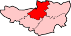
Weare and Lower Weare are small villages in Somerset, England, on the River Axe, south of the Mendip Hills. The parish comprises the villages of Upper and Lower Weare, and the hamlets of Alston Sutton, Brinscombe and Stone Allerton.
History
The name of the village may come from a weir on the River Axe.[2]
After the Norman conquest the manor was granted to Walter of Douai and then passed to the Gaunt, Gourney and Brythemore families. The Gourneys established a borough original called Nether Weare and later Lower Weare, and were granted the right to hold fairs and even sent members to the Parliament of England. This new borough declined after 1316; however a borough court was still being held in Lower Weare in 1603.[2]
Alston Sutton was a separate manor at the time of the Domesday Book in 1086. The name means Aethelnoth's settlement and was held in 1286 by Walter de Sutton. The village declined by 1548 and was largely demolished soon afterwards.[2]
Weare was part of the hundred of Bempstone.[3]
Governance
The parish council has responsibility for local issues, including setting an annual precept (local rate) to cover the council’s operating costs and producing annual accounts for public scrutiny. The parish council evaluates local planning applications and works with the local police, district council officers, and neighbourhood watch groups on matters of crime, security, and traffic. The parish council's role also includes initiating projects for the maintenance and repair of parish facilities, as well as consulting with the district council on the maintenance, repair, and improvement of highways, drainage, footpaths, public transport, and street cleaning. Conservation matters (including trees and listed buildings) and environmental issues are also the responsibility of the council.
The village falls within the Non-metropolitan district of Sedgemoor, which was formed on 1 April 1974 under the Local Government Act 1972, having previously been part of Axbridge Rural District,[4] which is responsible for local planning and building control, local roads, council housing, environmental health, markets and fairs, refuse collection and recycling, cemeteries and crematoria, leisure services, parks, and tourism.
Somerset County Council is responsible for running the largest and most expensive local services such as education, social services, libraries, main roads, public transport, policing and fire services, trading standards, waste disposal and strategic planning.
It is also part of the Wells county constituency represented in the House of Commons of the Parliament of the United Kingdom. It elects one Member of Parliament (MP) by the first past the post system of election, and part of the South West England constituency of the European Parliament which elects seven MEPs using the d'Hondt method of party-list proportional representation.
Religious sites
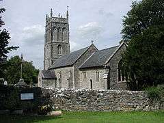
St. Gregory's Church dates from the 11th century and has been designated by English Heritage as a grade I listed building.[5] In the churchyard is a 15th-century cross,[6] and a19th century church room.[7] In 1257 the church was granted to St Augustine's Abbey in Bristol and after the dissolution of the monasteries given to the dean and chapter of Bristol Cathedral.[2]
Notable residents
- Alfred Brice, Welsh international rugby union forward who played club rugby for Aberavon and Cardiff was born in Weare.[8]
- Frankie Howerd, an English comedian, who lived nearby at Wavering Down in Cross is buried in St. Gregory's Church graveyard.[9]
References
- ↑ "Statistics for Wards, LSOAs and Parishes — SUMMARY Profiles" (Excel). Somerset Intelligence. Retrieved 4 January 2014.
- 1 2 3 4 Bush, Robin (1994). Somerset: The Complete Guide. Dovecote Press. p. 214. ISBN 1-874336-26-1.
- ↑ "Bempstone Hundred". A Vision of Britain Through Time. Retrieved 10 September 2011.
- ↑ "Axbridge RD". A vision of Britain Through Time. University of Portsmouth. Retrieved 4 January 2014.
- ↑ "Church of St Gregory". Images of England. Retrieved 3 March 2008.
- ↑ "Churchyard Cross in churchyard approximately 10 Metres South of Nave, Church of St Gregory". Images of England. English Heritage. Retrieved 9 February 2009.
- ↑ "Church Room, 15 metres north of tower, Church of St Gregory". Images of England. English Heritage. Retrieved 9 February 2009.
- ↑ Scrum.com player profiles
- ↑ "Frankie Howerd", NNDB
External links
| Wikimedia Commons has media related to Weare, Somerset. |
- Village web site
- The Somerset Urban Archaeological Survey: Lower Weare , by Miranda Richardson
- YouTube video of St. Gregory's Church
- Alston [Sutton] in the Domesday Book