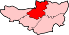
East Huntspill
| East Huntspill | |
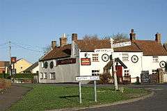 The Crown Inn and road junction |
|
 East Huntspill |
|
| Population | 1,146 (2011)[1] |
|---|---|
| OS grid reference | ST344454 |
| Civil parish | East Huntspill |
| District | Sedgemoor |
| Shire county | Somerset |
| Region | South West |
| Country | England |
| Sovereign state | United Kingdom |
| Post town | HIGHBRIDGE |
| Postcode district | TA9 |
| Dialling code | 01278 |
| Police | Avon and Somerset |
| Fire | Devon and Somerset |
| Ambulance | South Western |
| EU Parliament | South West England |
| UK Parliament | Bridgwater and West Somerset |
Coordinates: 51°11′56″N 2°56′28″W / 51.199°N 2.941°W
East Huntspill is a village and civil parish on the Huntspill Level, near Highbridge, Somerset, England. The civil parish includes Cote, Hackness and Bason Bridge.
The parish of East Huntspill has a population of 1,146.[1]
History
Until 1949 East Huntspill was part of the ancient parish and civil parish of Huntspill. The first mention of Huntspill is around 796 AD, when the area was granted to Glastonbury Abbey by Aethelmund, a nobleman under King Offa of Mercia.
Huntspill was listed in the Domesday Book of 1086 as Honspil, meaning 'Huna's creek' possibly from the Old English personal name Huna and from the Celtic pwll [2] as used in Welsh, e.g. Pwllheli. An alternative origin is from Hun's Pill in Old English, meaning a port on a tidal inlet, or pill, belonging to a Saxon lord, or hun.
The parish of Huntspill was part of the Huntspill and Puriton Hundred,[3]
Three 18th century farmhouses in East Huntspill, Hackney, New Road and Phippins, have all been designated as Grade II listed buildings.[4][5][6]
From 1856 to 1966 the village was served by Bason Bridge railway station on the Highbridge branch of the Somerset and Dorset Joint Railway.
In 1949 the civil parish of Huntspill was abolished and divided into Huntspill All Saints and West Huntspill along the line of the Bristol and Exeter Railway.[7] The parish of Huntspill All Saints was renamed East Hunstspill in 1972.[8]
Governance
The parish council has responsibility for local issues, including setting an annual precept (local rate) to cover the council’s operating costs and producing annual accounts for public scrutiny. The parish council evaluates local planning applications and works with the local police, district council officers, and neighbourhood watch groups on matters of crime, security, and traffic. The parish council's role also includes initiating projects for the maintenance and repair of parish facilities, as well as consulting with the district council on the maintenance, repair, and improvement of highways, drainage, footpaths, public transport, and street cleaning. Conservation matters (including trees and listed buildings) and environmental issues are also the responsibility of the council.
The village falls within the Non-metropolitan district of Sedgemoor, which was formed on 1 April 1974 under the Local Government Act 1972, having previously been part of Bridgwater Rural District,[9] which is responsible for local planning and building control, local roads, council housing, environmental health, markets and fairs, refuse collection and recycling, cemeteries and crematoria, leisure services, parks, and tourism.
Somerset County Council is responsible for running the largest and most expensive local services such as education, social services, libraries, main roads, public transport, policing and fire services, trading standards, waste disposal and strategic planning.
It is also part of the Bridgwater and West Somerset county constituency represented in the House of Commons of the Parliament of the United Kingdom. It elects one Member of Parliament (MP) by the first past the post system of election, and part of the South West England constituency of the European Parliament which elects seven MEPs using the d'Hondt method of party-list proportional representation.
Religious sites
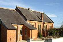
The Anglican parish Church of All Saints in East Huntspill was built in 1839 by G P Manners, as a chapel-of-ease to the then parish church at Huntspill. It became the parish church in 1845, when the chapelry was formed into a parochial district,[8] and the bell-chamber was added in the late 19th century.[10] It has been designated as a Grade II listed building.[11] It is on the Heritage at Risk register because of the condition of the roof.[12]
There was a United Methodist chapel in East Huntspill built in 1923, which replaced an earlier building in Chapel Lane. The chapel closed by 1997.[8]
See also
References
- 1 2 "Statistics for Wards, LSOAs and Parishes — SUMMARY Profiles" (Excel). Somerset Intelligence. Retrieved 4 January 2014.
- ↑ Robinson, Stephen (1992). Somerset Place Names. Wimborne, Dorset: The Dovecote Press Ltd. ISBN 1-874336-03-2.
- ↑ "Somerset Hundreds". GENUKI. Retrieved 15 October 2011.
- ↑ "Phippins Farmhouses, Barn and Forecourt Wall, New Road". National Heritage List for England. English Heritage. Retrieved 25 January 2015.
- ↑ "New Road Farmhouse". National Heritage List for England. English Heritage. Retrieved 25 January 2015.
- ↑ "Hackney Farmhouse with attached outbuilding and wall". National Heritage List for England. English Heritage. Retrieved 25 January 2015.
- ↑ Vision of Britain website
- 1 2 3 Robert Dunning, ed. (2004). "Huntspill". A History of the County of Somerset: Volume 8, the Poldens and the Levels. Victoria County History. British History Online. pp. 91–112. Retrieved 25 January 2015.
- ↑ "Bridgwater RD". A vision of Britain Through Time. University of Portsmouth. Retrieved 4 January 2014.
- ↑ "Church of All Saints". Images of England. English Heritage. Retrieved 2009-02-20.
- ↑ "Church of all Saints". National Heritage List for England. English Heritage. Retrieved 25 January 2015.
- ↑ "Church of All Saints, Church Road, East Huntspill — Sedgemoor". Heritage at Risk. English Heritage. Retrieved 14 October 2013.
Moore, R. (2005) A Parish Survey of East Huntspill and Bason Bridge (available via Somerset Studies Library, Taunton)
External links
![]() Media related to East Huntspill at Wikimedia Commons
Media related to East Huntspill at Wikimedia Commons
- A History of the County of Somerset: Volume 8: The Poldens and the Levels: Huntspill (2004)
- The Somerset Urban Archaeological Survey: Burnham and Highbridge by Clare Gathercole