Burnham-on-Sea High Lighthouse
 Burnham-on-Sea High Lighthouse | |
 Somerset | |
| Location |
Burnham-on-Sea Somerset England |
|---|---|
| Coordinates | 51°14′56″N 2°59′57″W / 51.248927°N 2.999078°WCoordinates: 51°14′56″N 2°59′57″W / 51.248927°N 2.999078°W |
| Year first constructed | 1832 |
| Deactivated | 1996 |
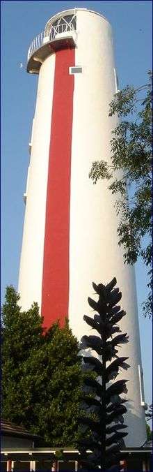
| Construction | brick tower |
| Tower shape | tapered cylindrical tower with half balcony |
| Markings / pattern | white tower with a red vertical stripe on sea side |
| Height | 30 metres (98 ft) |
| ARLHS number | ENG-018 |
| Managing agent | private |
The High lighthouse or pillar lighthouse is one of three lighthouses in Burnham-on-Sea, Somerset, England. A Grade II listed building, it is no longer functional as a lighthouse and has been used as a private dwelling.[1][2]
Burnham-on-Sea is notable for its beach and mudflats, which are characteristic of Bridgwater Bay and the rest of the Bristol Channel where the tide can recede for over 1.5 miles (2.4 km). Burnham is close to the estuary of the River Parrett where it flows into the Bristol Channel, which has the second highest tidal range in the world of 15 metres (49 ft),[3] second only to the Bay of Fundy in Eastern Canada.[4][5] The constantly shifting sands have always been a significant risk to shipping in the area.
The 30-metre (98 ft) pillar or High Lighthouse was designed and built by Joseph Nelson for Trinity House, in the 1830s and equipped with a paraffin lamp, which shone through a half-gallery under a window. It was used in conjunction with the Low lighthouse, which is still operating, to replace the original Round Tower Lighthouse, which itself had been built to replace the light kept burning in the tower of St Andrews Church to guide fishing boats into the harbour.
The ground floor was 5 metres (16 ft) in diameter and the top room 3 metres (9.8 ft).[6] It was automated in 1920.
In the 1990s it was deactivated[7] and sold by Trinity House and bought by a member of the Rothschild family. The red stripe on the building is still used as a day range.[8]
The Rothschild family owned it until 1996 when it was bought at auction by Patrick O'Hagan. Conversion for residential use included the removal of the 6th floor and the construction of stairs where there had previously only been ladders.[6]
See also
References
- ↑ "Burnham High Lighthouse and Nos 81 and 83, Berrow Road (West side), Burnham-on-Sea and Highbridge". Somerset Historic Environment Record. Somerset County Council. Retrieved 5 April 2010.
- ↑ "Burnham High Lighthouse". Images of England. Retrieved 10 December 2006.
- ↑ "Severn Estuary Barrage" (PDF). UK Environment Agency. 7 May 2008. Archived from the original (PDF) on 30 September 2007. Retrieved 3 September 2007.
- ↑ Chan, Marjorie A.; Archer, Allen William (2003). Extreme Depositional Environments: Mega End Members in Geologic Time. Boulder, Colorado: Geological Society of America. p. 151. ISBN 0-8137-2370-1.
- ↑ "Coast: Bristol Channel". BBC. Retrieved 27 August 2007.
- 1 2 "Burnham-on-Sea Lighthouse". Elspeth Beard architects. Retrieved 5 April 2010.
- ↑ "Burnham-On-Sea Lighthouses". Burnham on Sea.com. Retrieved 26 April 2010.
- ↑ Rowlett, Russ. "Lighthouses of Western England". University of North Carolina at Chapel Hill. Retrieved 6 October 2015.
| Wikimedia Commons has media related to Burnham High Lighthouse. |