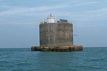
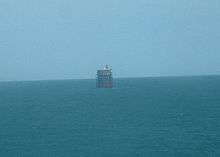
Nab Tower
 | |
 Hampshire | |
| Location | Nab Rocks, Near Isle of Wight, England |
|---|---|
| Coordinates | 50°40′03″N 0°57′04″W / 50.66749733°N 0.951162862°WCoordinates: 50°40′03″N 0°57′04″W / 50.66749733°N 0.951162862°W[1] |
| Year first constructed | 1819 (established lightship) |
| Year first lit | 1918 |
| Automated | 1983 |
| Foundation | steel and concrete |
| Construction | steel and concrete tower |
| Tower shape | massive cylindrical tower with a hexagonal prism light and helipad on the top |
| Markings / pattern | unpainted tower, white light |
| Height | 17 m (56 ft)[2] |
| Focal height | 17 m (56 ft) |
| Current lens | Vega VRB-25 medium intensity rotating beacon |
| Intensity | 2,850 candela[3] |
| Range | 12 nmi (22 km) |
| Characteristic | Fl W 10s. |
| Fog signal | 2 blasts every 30s. (range 2 nmi (3.7 km)) |
| Admiralty number | A0780 |
| NGA number | 1048 |
| ARLHS number | ENG 082 |
| Managing agent | Trinity Huse[4] |
The Nab Tower was a tower planned for anti-submarine protection in The Solent in World War I. It was sunk over the Nab rocks east of the Isle of Wight to replace a lightship after the war, and is a well-known landmark for sailors as it marks the deep-water eastern entry into the Solent.
History
During the First World War the British Admiralty designed eight towers codenamed M-N that were to be built and positioned in the Straits of Dover to protect allied merchant shipping from German U-boats. Designed by civilian Guy Maunsell, the towers were to be linked together with steel nets and armed with two 4-inch guns with the idea of closing the English Channel to enemy ships.
However, by the end of the war in 1918 only one had been completed, at a fantastic cost (at the time) of one million pounds, and was located at Shoreham Harbour, awaiting deployment. While another part-built tower would eventually be dismantled in 1924, there remained the completed 92-foot-tall (28 m) metal cylinder sitting on a raft of concrete.
In 1920 the completed tower was towed by two paddle-wheel tugs to the Nab rock, a rock in the deep-water approach to the eastern Solent and previously marked by a lightship. Buoyancy was provided by the honeycomb construction of the concrete base, creating 18 watertight compartments. When these were flooded, the structure sank and settled to rest at an angle of 3 degrees from vertical towards the northeast - a characteristic tilt which is obvious to this day.
The tower was featured as the main setting of the 1951 Hammer thriller, The Dark Light.
It was manned as a lighthouse, and during World War II it provided some defence to the Solent approach, and shot down several aircraft. The lighthouse is still functional but since 1983 it has been unmanned. It was converted to solar power operation in 1995.[5]
In November 1999 the merchant freighter Dole America, carrying a cargo of bananas and pineapples, hit the Nab. The ship was badly damaged and only avoided sinking by being run aground. The base of the tower suffered superficial and internal damage. The damage was repaired in 2001.
Major Refurbishment in 2013
In 2013, Trinity House commissioned BAM Nuttall to undertake a major refurbishment programme due to extensive corrosion of the upper levels, meaning it was unsafe to land helicopters upon the helipad. The height of the tower was reduced, all external steel and cladding were removed and the existing concrete sub-structure was coated in a new layer of gun-applied concrete. On completion, new AIS and RACON beacons were fitted, along with a fixed main light with a 12 nautical mile range. [6]
See also
References
- ↑ Latitude
- ↑ Nab Tower Lighthouse Retrieved May 3rd, 2016
- ↑ Nab Tower Lighthouse Retrieved May 3rd, 2016
- ↑ The Nab The Lighthouse Directory. University of North Carolina at Chapel Hill. Retrieved May 3rd, 2016
- ↑ "Nab Tower Lighthouse". Trinity House.
- ↑ "Renovation of Nab Tower lighthouse begins". Maritime Journal. Retrieved 12 December 2014.
External links
| Wikimedia Commons has media related to Nab Tower. |
- Trinity House
- Page with excellent photos and memories
- Page with details of post collision tower repairs
- Photos of ship after collision with Nab Tower