Bury Line
| Bury Line | |||||||||||||||||||||||||||||||||||||||||||||||||||||||||||||||||||||||||||||||||||||||||||||||||||||||||||
|---|---|---|---|---|---|---|---|---|---|---|---|---|---|---|---|---|---|---|---|---|---|---|---|---|---|---|---|---|---|---|---|---|---|---|---|---|---|---|---|---|---|---|---|---|---|---|---|---|---|---|---|---|---|---|---|---|---|---|---|---|---|---|---|---|---|---|---|---|---|---|---|---|---|---|---|---|---|---|---|---|---|---|---|---|---|---|---|---|---|---|---|---|---|---|---|---|---|---|---|---|---|---|---|---|---|---|---|
|
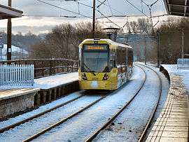
A M5000 at Radcliffe tram stop. | |||||||||||||||||||||||||||||||||||||||||||||||||||||||||||||||||||||||||||||||||||||||||||||||||||||||||||
| Overview | |||||||||||||||||||||||||||||||||||||||||||||||||||||||||||||||||||||||||||||||||||||||||||||||||||||||||||
| Type | Tram/Light rail | ||||||||||||||||||||||||||||||||||||||||||||||||||||||||||||||||||||||||||||||||||||||||||||||||||||||||||
| System | Manchester Metrolink | ||||||||||||||||||||||||||||||||||||||||||||||||||||||||||||||||||||||||||||||||||||||||||||||||||||||||||
| Locale |
Manchester Bury | ||||||||||||||||||||||||||||||||||||||||||||||||||||||||||||||||||||||||||||||||||||||||||||||||||||||||||
| Termini |
Manchester Piccadilly Bury Interchange | ||||||||||||||||||||||||||||||||||||||||||||||||||||||||||||||||||||||||||||||||||||||||||||||||||||||||||
| Stations | 10 | ||||||||||||||||||||||||||||||||||||||||||||||||||||||||||||||||||||||||||||||||||||||||||||||||||||||||||
| Operation | |||||||||||||||||||||||||||||||||||||||||||||||||||||||||||||||||||||||||||||||||||||||||||||||||||||||||||
| Opened | 6 April 1992 | ||||||||||||||||||||||||||||||||||||||||||||||||||||||||||||||||||||||||||||||||||||||||||||||||||||||||||
| Character | Converted railway track | ||||||||||||||||||||||||||||||||||||||||||||||||||||||||||||||||||||||||||||||||||||||||||||||||||||||||||
| Rolling stock | M5000 | ||||||||||||||||||||||||||||||||||||||||||||||||||||||||||||||||||||||||||||||||||||||||||||||||||||||||||
| Technical | |||||||||||||||||||||||||||||||||||||||||||||||||||||||||||||||||||||||||||||||||||||||||||||||||||||||||||
| Line length | 9.9 miles (15.9 km) | ||||||||||||||||||||||||||||||||||||||||||||||||||||||||||||||||||||||||||||||||||||||||||||||||||||||||||
| Track gauge | 1,435 mm (4 ft 8 1⁄2 in) standard gauge | ||||||||||||||||||||||||||||||||||||||||||||||||||||||||||||||||||||||||||||||||||||||||||||||||||||||||||
| Electrification | 750 volts DC overhead | ||||||||||||||||||||||||||||||||||||||||||||||||||||||||||||||||||||||||||||||||||||||||||||||||||||||||||
| Operating speed | 50 mph (80km/h) | ||||||||||||||||||||||||||||||||||||||||||||||||||||||||||||||||||||||||||||||||||||||||||||||||||||||||||
| |||||||||||||||||||||||||||||||||||||||||||||||||||||||||||||||||||||||||||||||||||||||||||||||||||||||||||
The Bury Line is a tram line of the Manchester Metrolink running from Manchester city centre to Bury in Greater Manchester. Originally a railway line, it was, along with the Altrincham Line, converted into a tram line during 1991–92, as part of the first phase of the Metrolink system.
The line runs entirely on an old railway alignment without any street running. It runs north from Manchester Victoria and connects the suburbs of Cheetham Hill, Prestwich, Whitefield and Radcliffe. The entire route from Victoria to Bury is roughly 10 miles (16 km) long. Two services travel along the line, both starting at Bury, and terminating at Altrincham and Etihad Campus respectively.
History
Pre-Metrolink
The line was originally a railway. The first part of what is now the Bury Line was opened by the East Lancashire Railway (ELR) in 1846, From Manchester Victoria to Bury Bolton Street via Salford, Clifton Junction and Radcliffe, continuing north from Bury to Rawtenstall. The ELR was absorbed into the Lancashire and Yorkshire Railway (L&YR) in 1859.[1]

The second part was opened in 1879: In order to connect the growing suburbs of Cheetham Hill, Prestwich and Whitefield, in 1872 the L&YR obtained an act to construct a new line from Manchester to the original ELR line at Radcliffe. Construction began in 1876 and was completed in 1879. Originally the line had only five intermediate stations at Crumpsall, Heaton Park, Prestwich, Whitefield and Radcliffe. Three more stations; Woodlands Road, Bowker Vale and Besses o' th' Barn were added later.[1]
In response to competition from trams, the line was electrified in 1916 using a unique 1,200 volt side-contact third rail system, which remained in operation until the line was converted to Metrolink operation in 1991.[1] From 1959 until 1991, the line was operated by Class 504 EMUs.
In August 1953, the Irk Valley Junction rail crash occurred on the line near Manchester Victoria, resulting in ten deaths and 58 injuries. It was caused when an electric train overran a danger signal, and collided with a steam train, resulting in the front carriage of the electric train crashing into the River Irk.[2]
The original Bury Bolton Street station was closed in 1980, and replaced by the new, more conveniently located Bury Interchange. The original Bolton Street station is now part of the East Lancashire Railway heritage railway.[1]
Conversion to Metrolink
The Bury line was identified by transport planners in the 1980s, as one of the local railway lines in the Greater Manchester area, which was used mostly for local traffic, and could therefore be split off from the main line network and converted to light-rail operation. It was chosen for conversion as part of the first phase of the Metrolink, along with the Manchester Piccadilly to Altrincham Line to the south of Manchester: The two previously unconnected lines were to be linked together by a new street-running line across Manchester city-centre, which included a branch to Manchester Piccadilly railway station. Trams on the Bury Line would thus continue from Victoria station into the city-centre, to either Altrincham or Piccadilly via a new exit into the streets to the south.[3]

Railway operations ended on 17 August 1991, in order for the line to be converted to Metrolink operation.[1] This mostly entailed removing the old third rail system and replacing it with a 750 volt DC overhead line system. Available funding only allowed for minimum upgrades to be made, and so most of the infrastructure such as the stations and track were changed little.[4]
The line became the first Metrolink line to open for business on 6 April 1992, initially between Bury and Victoria, it then opened to Altrincham on 15 June, and then Piccadilly on 20 July 1992.[5]
One of the original stations Woodlands Road was closed in 2013, after two new stations, (Abraham Moss and Queens Road) were opened nearby.[6]
Services
As of August 2016, trams between Bury and Manchester run as follows:[7]
- A 12-minute interval service from Bury to Altrincham. Running during Monday to Saturday daytimes and early evenings only.
- A 12-minute interval service From Bury to Etihad Campus. Running during all operating hours.
These two services combined mean that trams between Bury and Manchester operate every six minutes during Monday to Saturday daytimes, and every 12 minutes during evenings and Sundays. During evenings, trams run to Piccadilly only, so journeys to Altrincham require a change of tram at Piccadilly Gardens.
Rolling stock
All services are operated by M5000 trams. Between 1992 and 2009, the line was operated by the original fleet of 26 T-68 trams. From 2009 the new fleet of M5000 trams was introduced, and these replaced the original T-68 trams. which were withdrawn from service during 2012–14.[8]
Route map

See also
References
- 1 2 3 4 5 Hindle, Paul. "Manchester Victoria to Bury: an historical trip on Metrolink" (PDF). Manchester Geographical Society. Retrieved 10 January 2015.
- ↑ "Timeline: Fatal UK rail crashes". BBc News. Retrieved 5 February 2016.
- ↑ "Metrolink History 1". Light Rail Transit Association. Retrieved 9 January 2016.
- ↑ "Metrolink History 1". Light Rail Transit Association. Retrieved 10 January 2015.
- ↑ "An Introduction to Metrolink". Light Rail Transit Association. Retrieved 10 January 2015.
- ↑ "New Queens Road Metrolink stop to open". Transport for Greater Manchester.
- ↑ "Metrolink – Tram Times – Abraham Moss". Metrolink. Retrieved 30 August 2016.
- ↑ "T68 and T68a — Metrolink phase 1 and 2". Light Rail Transit Association. Retrieved 3 January 2016.
External links
| Tram stops |  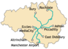 | |||||||||||||||||||||||||||||||
|---|---|---|---|---|---|---|---|---|---|---|---|---|---|---|---|---|---|---|---|---|---|---|---|---|---|---|---|---|---|---|---|---|
| Operations |
| |||||||||||||||||||||||||||||||
| History (Timeline) |
| |||||||||||||||||||||||||||||||
| Proposed stops |
| |||||||||||||||||||||||||||||||