Newbold tram stop
| Metrolink | |
|
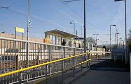
Newbold tram stop, on its opening day | |
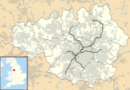
 Newbold Location of Newbold in Greater Manchester | |
| Location | |
| Place | Newbold |
| Local authority | Rochdale |
| Coordinates | 53°36′48″N 2°08′08″W / 53.6133°N 2.1355°WCoordinates: 53°36′48″N 2°08′08″W / 53.6133°N 2.1355°W |
| Grid reference | SD910130 |
| Platforms | 2 |
| Fare zone information | |
| Metrolink Zone | L |
| Present status | In operation |
| History | |
| Opened | 28 February 2013 |
|
| |
Newbold is a tram stop on the Oldham and Rochdale Line (ORL) of Greater Manchester's Metrolink network. It is located in the Newbold area of Rochdale, in the Metropolitan Borough of Rochdale, between the Kingsway and Rochdale Railway stations. It opened as part of Phase 3a of the system's expansion, on 28 February 2013.[1]
Services
Newbold is located on the Oldham & Rochdale Line with trams towards Manchester city centre and Rochdale Town Centre. Services are mostly every 12 minutes on all routes.
Connecting bus routes
| Route | Destination 1 | Destination 2 | Operator | Service | Stop Location |
|---|---|---|---|---|---|
| 58[2] | Rochdale | Middleton via Firgrove, Milnrow |
First | Mon-Sat Daytime | Milnrow Road |
| 181[3] | Rochdale | Manchester (Mon-Sat Daytime services depart from Shaw, Wren's Nest). |
First | Mon-Sat Evening All day Sunday |
Milnrow Road |
| 182[4] | Rochdale | Manchester |
First | Daytime & Evening | Milnrow Road |
| 451 (a)[5] | Rochdale | Peppermint Bridge via Firgrove, Milnrow, Newhey |
First | Mon-Sat Daytime |
Milnrow Road |
| 451 (b)[5] | Rochdale | Peppermint Bridge via Firgrove, Holt Estate, Milnrow (Precinct), Newhey |
MCT | Sunday Daytime | Milnrow Road |
| 462[6] | Rochdale | Ladyhouse Estate via Firgrove, Kingsway Business Park |
First | Mon-Sat Daytime | Milnrow Road |
| 434[7] | Rochdale via Belfield | Castleton |
MCT | Mon-Sat Daytime | Kingsway |
| 433[8] | Rochdale via Belfield | Castleton |
MCT | Sunday Daytime | Kingsway |
References
- ↑ "Next stop: Rochdale!". Transport for Greater Manchester. 20 February 2013. Retrieved 20 February 2013.
- ↑ http://www.tfgm.com/journey_planning/RouteMaps/58.pdf
- ↑ http://www.tfgm.com/journey_planning/RouteMaps/181.pdf
- ↑ http://www.tfgm.com/journey_planning/RouteMaps/182.pdf
- 1 2 http://www.tfgm.com/journey_planning/RouteMaps/451.pdf
- ↑ http://www.tfgm.com/journey_planning/RouteMaps/462.pdf
- ↑ http://www.tfgm.com/journey_planning/RouteMaps/434.pdf
- ↑ http://www.tfgm.com/journey_planning/RouteMaps/433.pdf
- ↑ "Transport for Greater Manchester - Journey Planning - Network Maps". Transport for Greater Manchester. Retrieved 4 March 2013.
External links
| Preceding station | Following station | |||
|---|---|---|---|---|
towards Exchange Square | Rochdale Town Centre – Exchange Square Line | towards Rochdale Town Centre |
| Railways in Rochdale | ||||||||||||||||||||||||||||||||||||||||||||||||||||||||||||||||||||||||||||||||||||||||||||||||||||||||||||||||||||||||||||||
|---|---|---|---|---|---|---|---|---|---|---|---|---|---|---|---|---|---|---|---|---|---|---|---|---|---|---|---|---|---|---|---|---|---|---|---|---|---|---|---|---|---|---|---|---|---|---|---|---|---|---|---|---|---|---|---|---|---|---|---|---|---|---|---|---|---|---|---|---|---|---|---|---|---|---|---|---|---|---|---|---|---|---|---|---|---|---|---|---|---|---|---|---|---|---|---|---|---|---|---|---|---|---|---|---|---|---|---|---|---|---|---|---|---|---|---|---|---|---|---|---|---|---|---|---|---|---|
Legend | ||||||||||||||||||||||||||||||||||||||||||||||||||||||||||||||||||||||||||||||||||||||||||||||||||||||||||||||||||||||||||||||
| ||||||||||||||||||||||||||||||||||||||||||||||||||||||||||||||||||||||||||||||||||||||||||||||||||||||||||||||||||||||||||||||
This article is issued from Wikipedia - version of the 11/13/2016. The text is available under the Creative Commons Attribution/Share Alike but additional terms may apply for the media files.


