C.N. Industrial, Saskatoon
| C.N. Industrial Area | |
|---|---|
| Neighbourhood | |
|
Early's Seed and Feed | |
| Coordinates: 52°5′21″N 106°39′49″W / 52.08917°N 106.66361°WCoordinates: 52°5′21″N 106°39′49″W / 52.08917°N 106.66361°W | |
| Country |
|
| Province |
|
| City | Saskatoon |
| Suburban Development Area | Nutana |
| Neighbourhood | C.N. Industrial Area |
| Annexed | 1960-1964 |
| CN Industrial 2 Annexed | 1965-1969 |
| Government | |
| • Type | Municipal (Ward 6) |
| • Administrative body | Saskatoon City Council |
| • Councillor | Charlie Clark |
| Population (2006) | |
| • Average Income | $ |
| Time zone | UTC (UTC-6) |
| List of neighbourhoods in Saskatoon | |
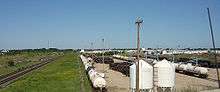
The CN Industrial Area is the industrial subdivision located in southern Saskatoon. It is also known as South Saskatoon, after the CN rail siding located in the area. It is a part of the Nutana Suburban Development Area. This industrial park was established with the Grand Trunk Pacific Railway crossing the South Saskatchewan River.
C.N. Industrial is bisected by Circle Drive, which directly links to all major highways entering the city, and is also connected directly to the Idylwyld Freeway, which links to downtown Saskatoon.
This neighbourhood on the east side of Saskatoon is not to be confused with the Canadian National Railway (C.N.) Yards Management Area located on Chappell Drive in the Confederation SDA of Saskatoon's west side. These two sides of Saskatoon are connected with the Grand Trunk Bridge or CN railway bridge over the South Saskatchewan River.
Geography
CN Industrial is bordered to the south by The Willows, Saskatoon, on the north by Idylwyld Drive and Avalon. Stonebridge is to the east, and Sk Hwy 219 to the west. Diefenbaker management area and the South Saskatchewan River are west of the CN Industrial area. The auto mall is a newer part of the CN Industrial area east of Portage Avenue to Clarence Avenue. There is a new interchange at Clarence Avenue and Idylwyld Drive to provide easier access to the area.
The Grand Trunk Bridge (Saskatoon) or CN Bridge crosses the South Saskatchewan River between the Queen Elizabeth Power Station on the upstream (west) side and Diefenbaker Park on the downstream (east) side. The train bridge commenced construction work in 1906 with rail line service beginning on September 21, 1908.[1] A southwest extension of Circle Drive, which opened in July 2013, passes through C.N. Industrial.[2] Access to businesses in C.N. Industrial is facilitated via an interchange at Lorne Avenue, but the area is now split into two sections with Jasper Avenue no longer crossing Circle Drive.
Economy
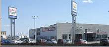
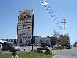
Some of the major employers in this area are Early Seed and Feed, Roadex Services, Ltd., and Speedway Moving & Storage. The Saskatoon Auto Mall, which opened on the east side of C.N. Industrial in the early 2000s, includes Saturn, Mini, Sherwood, Chevrolet, and BMW auto dealers, most of whom relocated to the auto mall from locations along 8th Street.[3]
In addition, retail development has occurred on the west side of Clarence Avenue south of Brand Road in the wake of development of the Stonebridge commercial hub to the east and new residential communities beyond it.
Location
 |
Exhibition | Avalon | Adelaide/Churchill | |
| R.M. of Corman Park | |
Stonebridge | ||
| ||||
| | ||||
| Furdale | The Willows | R.M. of Corman Park |
References
| Wikimedia Commons has media related to C.N. Industrial. |
- ↑ "The Wonder City". Retrieved 2008-05-12.
- ↑ "City of Saskatoon · Departments · Infrastructure Services ...". Archived from the original on August 7, 2007. Retrieved 2008-05-12.
- ↑ "Saskatoon Auto Mall - Used and New Cars, Trucks and RVs in Saskatoon, SK Canada". Retrieved 2008-05-12.
External links
- Neighbourhood Profiles
- Saskatoon Neighbourhoods Word Search Puzzle
- City of Saskatoon · Departments · Community Services · Community ...
- City of Saskatoon · Departments · Community Services · City Planning · ZAM Maps
- Populace Spring 2006