Riversdale, Saskatoon
| Riversdale | |
|---|---|
| Saskatoon Neighborhood | |
|
Roxy Theatre | |
 Riversdale location map | |
| Coordinates: 52°07′31″N 106°40′43″W / 52.12528°N 106.67861°WCoordinates: 52°07′31″N 106°40′43″W / 52.12528°N 106.67861°W | |
| Country | Canada |
| Province | Saskatchewan |
| City | Saskatoon |
| Suburban Development Area | Core Neighbourhoods |
| Neighbourhood | Riversdale |
| Settled | 1890 (as Richville) |
| Incorporated (village) | 1905 (as Riversdale) |
| Incorporated (city) | 1906 (as Saskatoon) |
| Government | |
| • Type | Municipal (Ward 2) |
| • Administrative body | Saskatoon City Council |
| • Councillor | Pat Lorje |
| • MLA | Danielle Chartier |
| • MP | Kelly Block |
| Area | |
| • Total | 0.87 km2 (0.34 sq mi) |
| Population (2011) | |
| • Total | 2,135 |
| • Density | 2,500/km2 (6,400/sq mi) |
| • Average Income | $53,086.00 |
| Time zone | CST (UTC-6) |
| Website | Riversdale Community Association |
Riversdale is one of the oldest neighbourhoods in Saskatoon, Saskatchewan, Canada, located near the downtown area. It includes the business district of 20th Street. It consists mostly of low-density, single detached dwellings. As of 2011, the area was home to 2,135 residents.
Riversdale has experienced an economic and development boom since 2012 and has even been called Canada's Next Great Neighbourhood.[1][2][3][4] However, the neighbourhood is still considered a lower-income area, with (based on the 2006 Canadian Census) an estimated average family income of $35,849, an estimated average dwelling value of $120,835 and an estimated home ownership rate of 36.0%[5] According to MLS data, the average sale price of a home as of 2013 was $224,807.[6]
Incorporated as a town in 1905, Riversdale was one of the three original settlements that merged to form the city of Saskatoon in 1906.[7]
History
The first record of settlement in the Riversdale area was in the 1890s, when the area was homesteaded. It was dubbed "Richville" after one of the original settlers.[8] In April 1903, over 1500 Barr Colonists arrived and made camp just west of the railway tracks beside Saskatoon. While most of the colonists moved on to the Lloydminster area, some remained behind as permanent residents of a new settlement.[9] The village of Riversdale was incorporated on January 16, 1905.[10] The village plan (originally called "Riverdale") had narrower streets, smaller lots, and no public reserve land.[11] Faced with a heavy influx of settlers, Riversdale joined with the towns of Saskatoon and Nutana to become the City of Saskatoon on July 1, 1906.[7]
Immigration from central and eastern Europe brought new and ethnically diverse peoples to Riversdale around 1908. Many British, German, Ukrainian and Chinese families took up residence. Separated from the downtown by the Canadian Northern Railway yards, vehicular access to Riversdale was limited to underpasses at 19th and 23rd Streets. In 1910, a pedestrian walkway was built over the train tracks at 20th Street so the public could safely cross the tracks on foot.[12] Saskatoon's Chinatown moved into the Riversdale district in the early 1930s. Originally, Chinese immigrants set up businesses along 19th Street east of the CN tracks, in what is now the south downtown. However, they moved when the city acquired the land to build the Saskatoon Technical Collegiate (later the Gathercole Building, now demolished).[13]
The mid-1960s marked a change in the traffic patterns of the area, as the CN tracks were relocated out of downtown. 20th and 22nd Streets were connected to the downtown, and Idylwyld Drive became Riversdale's eastern boundary.[14] The 23rd Street underpass was levelled quickly, while the 19th Street overpass remained until 2006. The mid-60s also saw First Nations people moving off of reserves and into Riversdale – the most recent statistics show that 43% of the population identifies as being of First Nations origin.[5] Vietnamese and Hong Kong Chinese immigrants also began arriving at this time.[10]
Riversdale's image struggled since the 1960s, with a sizeable portion of the population living below the poverty line. The social ills that accompany poverty – substance abuse, violent crime and dilapidated housing – often cast the area in a negative light.[15] However, by 2009 there was evidence of gentrification occurring in the area, including the River Landing development and the demolition of the historic but run-down Barry Hotel[16] being cited as examples of the neighbourhood's changing character.[17][18] By 2014, new businesses occupied nearly all of the available rental space.[19]
Historic buildings
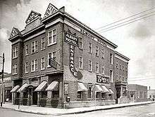
- Albany Hotel (1906) – Originally named the Iroquois Hotel, the business was renamed the Albany Hotel in 1912 after an extensive enlargement and alteration. Over the decades, the Albany gained a reputation as a "seedy" hotel and was the scene of many violent crimes. It closed in the late 1990s, and was acquired by Corrections Canada. Since 2000 it has served as a halfway house for federal offenders, under the name of Meewasinota Community Residence.[20][21]
- Adilman Building (1912/1949) – Adilman's Department Store was a cornerstone of the 20th Street shopping district from its opening in 1921 until it closed in 1974. The present structure is the result of a 1949 renovation, though the building's core dates to 1912. It is one of Saskatoon's examples of Streamline Moderne architecture. Since the department store closed, it has been home to an antique store, farmer's market, and bingo hall. In 2014 Freedom Functional Fitness, an unconventional fitness gym moved into the building.[22][23]
- Landa House (1912) – An attractive example of the Prairie Vernacular style, the house was first occupied by Saskatoon fire chief Thomas E. Heath. In 1921, the house was acquired by William and Fanny Landa, who were Jewish immigrants from Russia. William had opened a blacksmith shop in 1908, then expanded his business to manufacture buggies and wagons, which became Landa Auto Body Works. The business operates to this day at its original location on Avenue C. The house was designated a municipal heritage property on November 28, 2005.[24]
- St. Thomas Wesley United Church (1912) – Built on the corner of Avenue H and 20th Street in 1912, it was originally St. Thomas Presbyterian Church, named in honour of Thomas Copland, a civic and church leader. This red brick structure with Romanesque windows and a square bell tower, is topped with a stucco and wood belfry. In 1930 an agreement was reached between St. Thomas Presbyterian and Wesley Methodist to worship in the St. Thomas building under joint ministry – they formed St. Thomas Wesley United Church in 1934.[25] The wood and stucco bell tower was removed in 2008 after falling into disrepair.[26]
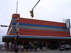
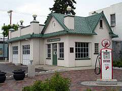
- Little Chief Service Station (1929) – Built as a Texaco service station in the 1920s, this building was built in the Spanish Colonial style. It features white stucco walls, rounded roof tiles, decorative brick, heavy tiled cornices, roof parapets, iron windows and copper gutters. It was named the West Side Service Station until 1943, when the name was changed to the Little Chief Service Station. After it ceased to be a service station, the Saskatoon Police Service obtained and renovated the building for use as a community police station. It was designated a municipal heritage property on January 11, 1982.[27]
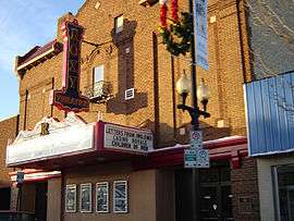
- Roxy Theatre (1930) – Built during the onset of the Great Depression. The interior was decorated in a Spanish Villa style with the walls covered with small balconies, windows and towers that gave the impression of a quaint Spanish village. The ceiling was painted dark blue and had twinkling lights set in the plaster to give the impression of the night sky. The Roxy was for a time called the Towne Cinema, then closed in 1995. It was purchased and restored by Magic Lantern Theatres, and reopened under its original name in 2005.[21]
- Ukrainian National Federation Hall (1932) – This hall, with its distinctive entryway lions, featured ornate interior decorations that ranged from busts of famous artists, musicians, and leaders, through to a stage flanked with castle-like walls. The building was used mainly for weddings, banquets, concerts and other public gatherings.[28]
- Ukrainian Orthodox Cathedral of the Holy Trinity (1952) – This church features an eight-sided dome which depicts the major feasts of the Church and Saints. 22-karat gold was used to decorate the church's icons. In 1988 the front of the cathedral gained a bronze statue of St. Volodymyr, the Baptizer of the Ukraine.[25]
Government and politics
Riversdale exists within the federal electoral district of Saskatoon-Rosetown-Biggar. It is currently represented by Kelly Block of the Conservative Party of Canada, first elected in 2008.
Provincially, the area overlaps two constituencies. The west part is within the constituency of Saskatoon Riversdale. It is currently represented by Danielle Chartier of the Saskatchewan New Democratic Party (NDP), first elected in a 2009 by-election. The east part lies within the constituency of Saskatoon Centre. It is currently represented by David Forbes of the NDP, first elected in a 2001 by-election and re-elected in 2003 and 2007.
In Saskatoon's non-partisan municipal politics, Riversdale lies within ward 2. It is currently represented by Councillor Pat Lorje. She was first elected in 1979, and was re-elected in 1982, 1985, and 1988. After a period of time as a NDP member of the Legislative Assembly of Saskatchewan, Lorje was again elected as Ward 2 councillor in 2006 and re-elected in 2009.
Institutions
Education
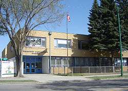
| Princess Alexandra Community School | |
|---|---|
 | |
| Location | |
|
210 Avenue H South Saskatoon, Saskatchewan, S7M 1W2 Canada | |
| Information | |
| Type | Elementary |
| Opened | 1962 |
| School board | Saskatoon Public Schools |
| Principal | Hugh Hamilton |
| Vice Principal | Chantelle Balicki |
| Grades | Kindergarten to Grade 8 |
| Enrollment | 105[29] (2016) |
| Education system | Public |
| Language | English |
| Feeder to | Bedford Road Collegiate |
| Website | Princess Alexandra Community School |
- Princess Alexandra School – public elementary school, part of the Saskatoon Public School Division.[30] The school first opened in 1906. Construction began in 1906/07 of 'Riversdale School which was renamed Alexandra School; a four-room school house was erected, and doubled in size by 1908.[31] In 1922 there were both Princess and Alexandra schools in operation on the same land allotment. Princess School was sold and torn down in 1961. In 1962 a new school building was erected on the same property site, and re-opened.[32]
Public safety
- Fire Hall No. 1 – fire station and headquarters of Saskatoon Fire & Protective Services[33]
- Little Chief Community Police Station
Other
- Riversdale House – seniors housing complex[34]
- White Buffalo Youth Lodge – Opened in 2000, this integrated service facility provides programming for Aboriginal youth. Health, recreation, life skills, vocational training and counselling programs are available.[35]
- Salvation Army Community Centre – In 1926 the Salvation Army opened what was then known as the "Relief Office" at 335 Avenue C South. By 1932 it was known as The Salvation Army Men's Hostel and Industrial Store where by 1943, had room for 40 men. In 1962 the centre had moved next door to its current location at 339 Avenue C South. Over the next several decades a chapel, half-way house, rehab unit, and more property was added until the centre took its current form.[36]
Arts and culture
- AKA Artist Run Centre – AKA evolved from the Shoestring Gallery, initiated in 1971. In 1982 the transition from a member-based visual arts and crafts co-operative to a non-profit artist-run centre yielded AKA Gallery.[37]
- La Troupe du Jour – Formed in 1985, La Troupe du Jour is Saskatchewan's only professional francophone theatre company.[38]
- PAVED Arts – PAVED Arts came into official existence on March 31, 2003 with the legal amalgamation of The Photographers Gallery (TPG) and Video Vérité (VV), the former a photography resource and exhibition centre, the latter a media access centre.[39]
- Roxy Theatre – Restored and re-opened in 2005, the Roxy Theatre shows movies Thursday through Sunday, weekend matinees and hosts several live and musical events & promotions throughout the year.[40]
- Saskatchewan Native Theatre Company – Launched in 1999, the SNTC creates, develops and produces artistic presentations by Canadian Aboriginal artists.[41]
Parks and recreation
- Victoria Park (7.0 acres) – named for Queen Victoria, this public park houses many facilities. However, only a small portion of the park lies within Riversdale; the majority of the park is in the King George neighbourhood to the south.
- Optimist Park (7.1 acres)
- Isinger Park (2.5-acre (1.0 ha)) – built as part of Phase II of the River Landing development, opened in August 2009[42][43]
The Riversdale Community Association coordinates educational, recreational, and social programs for residents, maintains the outdoor rink at Princess Alexandra Community School, stages fundraising events, and works to address issues of local concern.[44]
Commercial
Riversdale's main commercial corridor is 20th Street, which was the main street in its early days as a village. Today, 20th Street is home to mainly independently-owned local businesses. Other businesses are located on 22nd Street, the major arterial road that makes up the northern boundary of Riversdale. Commercial and light industrial businesses occupy some of the blocks between 19th and 22nd Streets, concentrated on the eastern side closer to Idylwyld Drive. The Saskatoon Farmers' Market, founded in 1975, moved into its present location at 19th Street and Avenue B in 2007.
Transportation
Riversdale is served by Saskatoon Transit bus routes #2, #9 #10, #60 and #65. Route #5 also runs along 23rd Street, a block north of the neighbourhood boundary.
Location
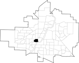
Riversdale is located within the Core Neighbourhoods Suburban Development Area. It is bounded by 22nd Street to the north and Idylwyld Drive to the east. The southern boundary starts at the Senator Sid Buckwold Bridge, follows the South Saskatchewan River west until where it intersects an imaginary extension of 18th Street; it follows 18th Street west with a few turns until roughly Avenue K. The western boundary comprises the CPR tracks in the northwest until Avenue K, then a few turns until roughly 18th Street. Roads are laid out in a grid fashion; streets run east-west, avenues run north-south.
References
- ↑ http://www.thestarphoenix.com/news/Riversdale+condos+planned+Great+West+Warehouse+site/8219958/story.html
- ↑ http://www.thestarphoenix.com/business/Victoria+developer+bullish+Riversdale/7885536/story.html
- ↑ "I Heart Saskatoon, and I Know You Will Too". The Huffington Post. Retrieved 26 March 2015.
- ↑ "Canada's Next Great Neighbourhoods: Riversdale, Saskatoon". aircanada.com. Retrieved 26 March 2015.
- 1 2 "Riversdale" (PDF). Neighbourhood Profiles. City of Saskatoon – Planning & Development Branch. 2010. Retrieved 2012-09-20.
- ↑ "Riversdale". Saskatoon Realty. Retrieved 2014-01-08.
- 1 2 Jeff, O'Brien (July 2005). "A History of Saskatoon to 1914" (PDF). City of Saskatoon – Archives. Retrieved 2010-12-10.
- ↑ "A View from Above – Key to Landmarks". City of Saskatoon. Retrieved 2010-12-10.
- ↑ Coneghan, Daria (2006). "Saskatoon". Encyclopedia of Saskatchewan. Canadian Plains Research Center. Retrieved 2010-12-10.
- 1 2 "History". Village of Riversdale. Riversdale Business Improvement District. Retrieved 2010-12-10.
- ↑ Delainey, William P. (April 23, 2007). "The South Saskatchewan River and the Development of Early Saskatoon 1881–1908: A Historical Narrative" (PDF). City of Saskatoon – Community Development Branch. Retrieved 2010-12-07.
- ↑ O'Brien, Jeff; Ruth W. Millar; William P. Delainey (2006). Roberta Coulter, ed. Saskatoon: A History in Photographs. Coteau Books. p. 19. ISBN 1-55050-336-7.
- ↑ O'Brien, Jeff; Ruth W. Millar; William P. Delainey (2006). Roberta Coulter, ed. Saskatoon: A History in Photographs. Coteau Books. p. 47. ISBN 1-55050-336-7.
- ↑ Burdeniuk, Trelle (September 20, 2012). "Rebuilding Riversdale Part 4: A look back – Remembering the Riversdale that was". News Talk 650 CKOM. Rawlco. Retrieved 2012-09-20.
- ↑ Kitchen, Peter (2006). "Exploring the Link between Crime and Socio-Economic Status in Ottawa and Saskatoon: A Small-Area Geographical Analysis" (PDF). Government of Canada – Department of Justice. Retrieved 2009-11-20.
- ↑ HOTEL&MR=20&RF=www_Canned%20Searches&QB2=AND&QF2=THUMBNAIL_IMAGE&QI2=* "Popular Searches of the Local History Room Collections Database" Check
|url=value (help). Local History Room Databases. Saskatoon Public Library. Retrieved 2012-07-06. - ↑ Maclean, Rory (April 7, 2010). "A neighbourhood divided". The Sheaf. Sheaf Publishing Society. Retrieved 2010-12-08.
- ↑ MacPherson, Alex (2015-10-16). "Touting 20th Street's potential". The StarPhoenix. Postmedia Network. Retrieved 2015-10-16.
- ↑ Rockcliffe, Amber (2014-06-01). "Saskatoon Riversdale rental space getting more competitive". Global News. Retrieved 2016-02-07.
- ↑ "Minutes of the Regular Meeting of City Council" (PDF). City of Saskatoon. August 14, 2000. p. 22. Retrieved 2010-12-08.
- 1 2 "Riversdale Walking Tours". Riversdale BID. 2007. Retrieved 2010-12-08.
- ↑ http://freedomsaskatoon.com/
- ↑ "Stop 76: Adilman's Department Store". Exploring the Wonder City – Driving Tour. Greater Saskatoon Catholic School Division. 2006. Retrieved 2010-12-10.
- ↑ "Landa House". City of Saskatoon. 2009. Retrieved 2007-10-16.
- 1 2 "Stop 81: St. Thomas Wesley United Church/Ukrainian Orthodox Holy Trinity Cathedral". Exploring the Wonder City – Driving Tour. 2006. Retrieved 2010-12-08.
- ↑ Polachic, Darlene (September 20, 2008). "St. Thomas Wesley situated for service". The StarPhoenix. Postmedia Network. Retrieved 2010-12-08.
- ↑ "Little Chief Service Station". Municipal Heritage Properties. City of Saskatoon – Development Services Branch. 2009. Retrieved 2010-12-10.
- ↑ "Stop 80: Ukrainian National Federation Hall". Exploring the Wonder City – Driving Tour. Greater Saskatoon Catholic School Division. 2006. Retrieved 2010-12-10.
- ↑ Active List of Saskatchewan Schools/Programs (PDF), retrieved 2016-11-28
- ↑ "Princess Alexandra Public Community School". Saskatoon Public School Division. Retrieved 2010-12-10.
- ↑ "Narratives of Saskatoon: 1882–1912". Saskatoon Gen Web Project. University of Saskatchewan Bookstore. 1927. Retrieved 2010-12-10.
- ↑ Blashill, Lorraine (1982). "Chapter XI: Expanding Services". From a little stone school... the story of the development of the Saskatoon Public School System over the past one hundred years. Saskatoon, Saskatchewan: Modern Press. p. 117.
- ↑ "Divisions – Central". Fire and Protective Services. Retrieved 2010-12-07.
- ↑ "Riversdale House". Directory of Seniors' Housing in Saskatoon. Saskatoon Public Library. April 2010. Retrieved 2010-12-10.
- ↑ "White Buffalo Youth Lodge". Retrieved 2010-12-10.
- ↑ "About the Salvation Army Community Services in Saskatoon". Retrieved 2010-12-10.
- ↑ "About AKA". AKA Gallery. Retrieved 2010-12-10.
- ↑ "History". La Troupe du Jour. Retrieved 2010-12-10.
- ↑ "History". PAVED Arts. Retrieved 2007-10-17.
- ↑ O'Brien, Jeff; Ruth W. Millar; William P. Delainey (2006). Roberta Coulter, ed. Saskatoon: A History in Photographs. Coteau Books. p. 68. ISBN 1-55050-336-7.
- ↑ "Company Profile". Saskatchewan Native Theatre Company. Retrieved 2010-12-10.
- ↑ "River Landing – Project Update – Isinger Park". November 16, 2009. Retrieved 2010-12-10.
- ↑ "Riversdale" (PDF). City of Saskatoon – Parks Department. Retrieved 2010-12-10.
- ↑ "Riversdale Community Association". Community Associations. City of Saskatoon – Community Services Department. 2009. Retrieved 2010-12-10.
Further reading
- Arlean McPherson, Riversdale Businesses: an Historical Sampler, 1992.
- Riversdale Neighbourhood Improvement Office, City of Saskatoon Saskatchewan Report on the Riversdale Neighbourhood Improvement Program, 1976.
- Mark Hunter, Things in Your Neighbourhood: Riversdale Photographic Survey, 1991.
External links
| Wikimedia Commons has media related to Riversdale. |
- Riversdale neighbourhood profile
- Riversdale Local Area Plan
- Riversdale Community Association
- Riversdale Business Improvement District
 |
Pleasant Hill | Caswell Hill | Central Business District | |
| West Industrial | |
Central Business District | ||
| ||||
| | ||||
| West Industrial | King George | South Saskatchewan River Nutana |