Caguas, Puerto Rico
| Caguas, Puerto Rico | |||
|---|---|---|---|
| Autonomous Municipality of Caguas | |||
| |||
| Nickname(s): "La Ciudad del Turabo" (Turabo Valley), "La Ciudad Criolla" (Creole City) | |||
| Anthem: "Caguas" | |||
 Location of Caguas in Puerto Rico | |||
| Coordinates: 18°13′53″N 66°2′22″W / 18.23139°N 66.03944°WCoordinates: 18°13′53″N 66°2′22″W / 18.23139°N 66.03944°W | |||
| Country | United States | ||
| Territory | Puerto Rico | ||
| Founded | January 1, 1775 | ||
| Government | |||
| • Mayor | William Miranda Torres (PPD) | ||
| • Senatorial dist. | 7 | ||
| • Representative dist. | 31,32 | ||
| Area | |||
| • Total | 59.07 sq mi (153.00 km2) | ||
| • Land | 58.68 sq mi (151.97 km2) | ||
| • Water | 0.40 sq mi (1.03 km2) | ||
| Elevation | 2,110 ft (643 m) | ||
| Population (2010) | |||
| • Total | 142,893 | ||
| • Density | 2,400/sq mi (930/km2) | ||
| Demonym(s) | Cagüeños caguenses | ||
| Ethnicity(2000 Census)[1] | |||
| • White | 84.5% | ||
| • Black | 7.8% | ||
| • American Indian/AN | 0.6% | ||
| • Asian | 0.3% | ||
| • Native Hawaiian/PI | 0.1% | ||
| Time zone | AST (UTC-4) | ||
| Zip code | 00725, 00726, 00727 | ||
| Area code(s) | +787 | ||
| Website | caguas.gov.pr | ||
Caguas (Spanish pronunciation: [ˈkaɣwas]), founded in 1775, is a city and municipality of Puerto Rico located in the Central Mountain Range of Puerto Rico, south of San Juan and Trujillo Alto, west of Gurabo and San Lorenzo, east of Aguas Buenas, Cidra, and Cayey.
Caguas is located 20 miles (32 km) (twenty minutes to an hour by car) from San Juan and 40 miles (64 km) (an hour and a half by car; it may take longer because of mountainous area in between the two cities) from Ponce. It is known as El Valle del Turabo (Turabo Valley) or La Ciudad Criolla (The Creole City) and its name originates from the Taíno cacique Caguax. Caguas is both a principal city of the San Juan-Caguas-Guaynabo Metropolitan Statistical Area and the San Juan-Caguas-Fajardo Combined Statistical Area.[2]
History
Caguas was founded on January 1, 1775 as San Sebastián del Piñal de Caguax, later shortened and modernized to its current form. Caguax was a local Taíno chief and early convert to Christianity. Caguas' construction was finished in 1779, in 1820 it was declared a valley and in 1894 it became a city.[3]
In 2002, Caguas was the site of the 2002 USAF Hercules air disaster.[4]
Geography
Caguas is located in the largest valley in Puerto Rico, the "Valle de Caguas" which it shares with Gurabo and part of Aguas Buenas. It is located approximately 30 minutes from the coastline both on the east (Humacao) and the north (San Juan), and is divided from the Gurabo portion of the valley by the river of the same name. It is east of Aguas Buenas and Cidra, north of Cayey, south of San Juan, and west of Gurabo and Trujillo Alto. It also shares borders with Guayama and Patillas via a five-point border, with Cayey and San Lorenzo. At this point there are two tall antennas which provide signal to Puerto Rico's principal TV stations such as WKAQ-TV and WAPA-TV. No road passes exactly at this point, and it can be approached nearby through Puerto Rico Highway 184. Being a valley, Caguas has the distinction of being relatively flat except near the borders with all the mentioned municipalities except Gurabo.
Water features
- The Río Grande de Loíza divides this municipality from Gurabo.
- Other Rivers: Río Turabo, Río Caguitas, Río Cañaboncito, Río Bairoa and Río Cañas.
Climate
The climate is classified as a Tropical monsoon climate, meaning the daily mean temperature from month to month is never less than 64.4 °F (18 °C), and there is a distinct wet and dry season. Rainfall is common in relative abundance throughout most of the year, although there is less rain than in the eastern coastal valleys. The land, however, is fertile and deep.
| Month | Jan | Feb | Mar | Apr | May | Jun | Jul | Aug | Sep | Oct | Nov | Dec | Year |
|---|---|---|---|---|---|---|---|---|---|---|---|---|---|
| Record high °C (°F) | 33 (92) |
34 (93) |
35 (95) |
35 (95) |
36 (97) |
37 (99) |
37 (99) |
37 (98) |
38 (101) |
37 (99) |
35 (95) |
35 (95) |
38 (101) |
| Average high °C (°F) | 26.3 (79.3) |
27.2 (80.9) |
30.2 (86.4) |
31.2 (88.1) |
31.9 (89.4) |
32.5 (90.5) |
32.6 (90.7) |
32.8 (91.1) |
32.8 (91.0) |
32.2 (90.0) |
30.8 (87.4) |
29.4 (84.9) |
30.8 (87.5) |
| Daily mean °C (°F) | 21.6 (70.9) |
21.7 (71.1) |
23.5 (74.3) |
25.1 (77.1) |
26.4 (79.6) |
27.4 (81.4) |
28.2 (82.7) |
28.1 (82.5) |
28.2 (82.8) |
27.6 (81.6) |
25.6 (78.1) |
24.1 (75.4) |
25.6 (78.1) |
| Average low °C (°F) | 16.9 (62.5) |
16.2 (61.1) |
16.8 (62.3) |
18.9 (66.0) |
21 (69.8) |
22.4 (72.4) |
23.7 (74.7) |
23.3 (74.0) |
23.7 (74.7) |
22.9 (73.2) |
20.4 (68.7) |
18.8 (65.8) |
20.4 (68.8) |
| Record low °C (°F) | 10 (50) |
10 (50) |
9 (49) |
13 (56) |
17 (62) |
18 (65) |
19 (66) |
19 (67) |
19 (66) |
18 (64) |
15 (59) |
14 (57) |
9 (49) |
| Average rainfall mm (inches) | 77.5 (3.05) |
68.1 (2.68) |
35.3 (1.39) |
109.7 (4.32) |
265.7 (10.46) |
107.2 (4.22) |
87.9 (3.46) |
127.8 (5.03) |
247.4 (9.74) |
180.8 (7.12) |
199.9 (7.87) |
106.7 (4.20) |
1,511.8 (59.52) |
| Average snowfall cm (inches) | 0 (0) |
0 (0) |
0 (0) |
0 (0) |
0 (0) |
0 (0) |
0 (0) |
0 (0) |
0 (0) |
0 (0) |
0 (0) |
0 (0) |
0 (0) |
| Average rainy days (≥ 0.10) | 9 | 7 | 6 | 12 | 18 | 11 | 8 | 10 | 14 | 10 | 18 | 9 | 100 |
| Average snowy days (≥ 1.00) | 0 | 0 | 0 | 0 | 0 | 0 | 0 | 0 | 0 | 0 | 0 | 0 | 0 |
| Source: Southeast Regional Climate Center [5] | |||||||||||||
Cityscape
Barrios
- Caguas Pueblo
- Bairoa
- Beatriz
- Borinquen
- Cañabón
- Cañaboncito
- Rio Cañas
- San Antonio
- San Salvador
- Tomás de Castro
- Turabo
Tourism
Landmarks and places of interest

- Botanical and Cultural Gardens
- Caguas Historical Museum
- Caguas Cathedral
- Coquí Villa
- Hacienda Catalina Ruins
- Hacienda Cofresí
- Hacienda Country Club
- Jardín Botánico y Cultural William Miranda Marín
- La Casa de Ajedrez (The House of Chess)
- Tobacco Museum
- Catedral Dulce Nombre De Jesus (In town plaza founded in 1729 and constructed in 1774).
Culture
Festivals and events
- Rosario Cantado a los Reyes – 4 January
- Three Kings Festival – 5 January
- Criolla Beatriz – February
- Criolla Borinquen Fair – March
- Criolla Cañabón Fair – April
- Felipe "La Voz Rodríguez' Birthday – 8 May
- Al Fresco – Every last Friday of each month
- Cross Festival – 23–31 May
- Typical Criole Festival – 1–2 June
- Latin American Musical
Sports
The Criollos de Caguas baseball team is considered one of the greatest of all-time in all of Latin America, having won 16 national Puerto Rico titles and 3 Caribbean World Series titles The team is a member of the Liga de Béisbol Profesional de Puerto Rico (LBPPR). Three of the first five Puerto Ricans that played Major League Baseball in the U.S., at one point in their careers played for the Criollos de Caguas (Luis Rodríguez Olmo, Victor Pellot Power, Roberto Clemente).
The Criollos de Caguas basketball team, founded in 1968 by Dr. Héctor "Tato" Dávila and Lcdo. Libertario Pérez Rodríguez, hasn't enjoyed as much success as their baseball counterparts. However in the early 2000s, they showed a lot of progress by reaching the national playoffs various times. The team is a member of the BSN. In 2006, the team won its first BSN national basketball championship, defeating Flor Melendez and his Santurce Crabbers in five games.
Caguas is home to the Bairoa Gym, one of the most important boxing gyms in all Puerto Rico and a place where many visiting champions have trained at; such as boxing Welterweight Champion Miguel Cotto, his brother Jose Miguel, Alberto Mercado, Juan Carazo, Alfredo Escalera and others.
The Criollas de Caguas women's volleyball team has won 9 national Puerto Rico titles and has made it to the finals more than 15 times. The team is a member of the Liga de Voleibol Superior Femenino (LVSF).
Economy
In September 2005 City Mayor William Miranda Marin levied the first Municipal tax in Puerto Rico via city ordinance. Area Merchants now charge a one cent tax for every dollar spent on all retail businesses. The tax has become known around the island as the "Willie Tax." It resulted in an estimated $500,000 monthly income for the city. However, the municipal tax was increased to 1.5% after the establishment of the 5.5% state tax for a total of 7%.
During 2006, Miranda Marin began calling Caguas "El Nuevo Pais de Caguas" ("The New Country of Caguas").
Agriculture
Its community has enjoyed one of the more robust economies amongst Puerto Rican cities since the 1980s. During the early part of the 20th century, Caguas hosted one of Puerto Rico's most important sugar manufacturers, which gave employment to thousands of Cagüeños.
Business
Numerous businesses and important buildings have opened in Caguas since the 1980s, including the imposing 23 story apartment building Caguas Tower, its adjacent competitors Bonneville Apartments, and the 10 floor Menonita Hospital. There are also several shopping malls:
- Plaza del Carmen Mall,
- Plaza Centro Mall
- Las Catalinas Mall
- Los Prados Mall
- Bairoa Shopping Center
- Villa Blanca Mall
- Angora Shopping Center
- Plaza Degetau
- Plaza Caguitas
- Del Rio Shopping Center
- Metro Plaza
Demographics

Caguas is one of the largest municipalities with a population of 142,893 (increase of 1.7 percent).*
Male Population in Caguas Barrio-pueblo, Puerto Rico: 10,351
Female Population in Caguas Barrio-pueblo, Puerto Rico: 12,629
(updated 2013)**
Median Male Resident Age in Caguas, Puerto Rico: 35.9
Median Female Resident Age in Caguas, Puerto Rico: 41.9
(updated 2013)**
'Races in Caguas, Puerto Rico'
• White: 18,584 • African American: 2,245 • American Indian: 65 • Asian: 26 • Native Hawaiian and Other Pacific Islander: 0 • Some Other Race: 1,585 • Two or More Races: 475
(updated 2013)**
Household Income (Caguas Zona Urbana, Puerto Rico)
Less than $10,000 : 8,786
$10,000 to $14,999 : 3,297
$15,000 to $19,999 : 2,684
$20,000 to $24,999 : 2,685
$25,000 to $29,999 : 2,142
$30,000 to $34,999 : 2,144
$35,000 to $39,999 : 1,302
$40,000 to $44,999 : 1,389
$45,000 to $49,999 : 1,080
$50,000 to $59,999 : 1,521
$60,000 to $74,999 : 1,532
$75,000 to $99,999 : 1,194
$100,000 to $124,999 : 690
$125,000 to $149,999 : 111
$150,000 to $199,999 : 284
$200,000 or more : 65
(updated 2013)**
Land Area: 58.6 sq mi Density: 2438.4 per sq mi Median Age: 37.3 ***
 * [6]
** [7]
Government
All municipalities in Puerto Rico are administered by a mayor, elected every four years. The mayor of the city of Caguas were
1953 to 1969 - Angel Rivera PPD
1969 to 1973 - Miguel Hernandez Rodriguez (New Progressive Party (PNP))
1973 to 1977 - Angel O. Berrios Diaz (PPD)
1977 to 1981 - Miguel Hernandez Rodriguez (PNP)
1981 to 1997 - Angel O. Berrios Diaz (PPD)
1997 to 2010 - William Miranda Marín (PPD)
2010 to present - William Miranda Torres (PPD)
The city belongs to the Puerto Rico Senatorial district VII, which is represented by two Senators. In 2012, Jorge Suárez and José Luis Dalmau were elected as District Senators.[9]
Symbols
Flag and Coat of arms
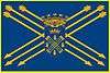
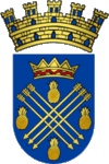
The colors blue and gold were chosen for the shield, distinctive of the city of Caguas. The figures symbolize both the indigenous and Christian origins of this city.
The coat of arms consists of a shield with a blue field. Upon the field are two sets of three golden arrows, forming a cross of St. Andrew. Above the cross is a crown which represents Caguax, cacique of the Turabo Valley at the time of the arrival of the Spanish conquerors.
Arrows were used as a remembrance of the first Christian place of worship established in the region which was dedicated under the patronage of St. Sebastian. There are pineapples interspersed to reflect the native agriculture. A castellated wall surmounts the shield to show the city's having been granted status as a municipality by the Spanish Crown.
On the flag, the shield sits atop another blue field on which the cross of arrows is repeated.
Transportation
Public transportation in Caguas, as in most of Puerto Rico, is limited to small "guaguas públicas" (Mini Bus). There is service to and from San Juan and Rio Piedras, inexpensive but slow. Within Caguas, several buses and taxis serve the town.
A "light interurban rail" system connecting Caguas to San Juan is in the planning stages, and will act as a feeder for the Tren Urbano.
Caguas is served by one freeway, one tolled expressway and one main divided highway. Puerto Rico Highway 30 connects Caguas to the east. There is no freeway/expressway to the west, due mainly to the fact that there is no sufficient population west of Caguas to develop a new freeway or expressway; good access to the municipalities of Cidra(southwest) and Aguas Buenas(northwest) are possible via PR-172 and PR-156, respectively. Puerto Rico Highway 52 connects Caguas to the north (San Juan) and south (Cayey, Ponce). Puerto Rico Highway 1 is an alternate route to San Juan and Guaynabo with two lanes per direction; in south Caguas it becomes rural near Borinquen, therefore the only good access to Cayey is the expressway (PR-52) and a $1.00 toll has to be paid (only in the south direction). The only municipality bordering Caguas with a poor-access road is San Lorenzo, via PR-183; but good access to San Lorenzo is possible by entering Gurabo via PR-30, and then taking PR-203 south.
Luis Munoz Marin International Airport is about 35 minutes away by car.
Education
High schools
- Colegio Católico Notre Dame
- Elohim Christian Academy
- New Generation Christian Academy (used to be CLA)
- Caguas Military Academy
- Colegio Bautista
- Colegio Católico San Juan Apóstol
- Academia Cristo de los Milagros
- Dr. Juan José Osuna High school
- José Gautier Benítez High school
- Manuela Toro Morice High School
- Republic of Costa Rica Vocacional High School of Caguas
- Eloisa Pascual "Bairoa III" High School
- Rio Cañas High School
- Santa Rosa Superior School
- Thomas Alva Edison School
- Colegio San José Superior
- Escuela de Ciencias y Tecnología
- Caguas Private School (CPS)
Higher education
- San Juan Bautista School of Medicine
- Huertas Junior College
- Instituto EDIC
- Columbia College
- Turabo University at Gurabo (Gurabo, Puerto Rico)
Health care
- Hospital Hima San Pablo
- Menonita Caguas Regional Hospital
- San Juan Bautista Medical Center
- Corporacion SANOS
Sister cities

 Southbridge, Massachusetts, United States
See also
Notes and references
- ↑ Demographics/Ethnic U.S 2000 census
- ↑ Grupo Editorial EPRL (June 4, 2015). Fundación Puertoriqueña de las Humanidades, ed. "Caguas". Enciclopedia de Puerto Rico (in Spanish). Retrieved June 28, 2015.
- ↑ "Caguas, Puerto Rico". Retrieved 15 September 2016.
- ↑ Ranter, Harro. "ASN Aircraft accident Lockheed MC-130H Hercules 90-0161 Caguas". Retrieved 15 September 2016.
- ↑ "CAGUAS, PUERTO RICO". The University of North Carolina (Chapel Hill campus). Retrieved 26 October 2011.
- ↑ "U.S. Census Bureau Delivers Puerto Rico's 2010 Census Population Totals, Including First Look at Race and Hispanic Origin Data for Legislative Redistricting - 2010 Census - Newsroom - U.S. Census Bureau". Census.gov. Retrieved 2016-09-16.
- ↑ "Demographics Analysis of Caguas Barrio-pueblo, Puerto Rico". Retrieved 15 September 2016.
- ↑ "Caguas, Puerto Rico". Retrieved 15 September 2016.
- ↑ Elecciones Generales 2012: Escrutinio General on CEEPUR
References
- Caguas and its barrios, United States Census Bureau
- Carrasquillo, Rosa E. (2006). Our Landless Patria: Marginal Citizenship and Race in Caguas, Puerto Rico, 1880–1910. Lincoln, Nebraska: University of Nebraska Press. OCLC 61204347.
External links
| Wikivoyage has a travel guide for Caguas. |
- Official Web site (Spanish)
- Eastern Center Virtual Library (Spanish)
- Caguas Community Portal (Spanish)
- Huertas Junior College (Spanish)
- San Juan Bautista School of Medicine
- Columbia College (Spanish)
- Grand Valley State University(Spanish)
- Jardín Botánico y Cultural William Miranda Marín (Spanish)