California State Capitol Museum
| California State Capitol Museum | |
|---|---|
|
| |
  | |
| Location | Sacramento County, California, USA |
| Nearest city | Sacramento, California |
| Coordinates | 38°34′35″N 121°29′36″W / 38.57639°N 121.49333°WCoordinates: 38°34′35″N 121°29′36″W / 38.57639°N 121.49333°W |
| Area | 40 acres (16 ha) |
| Established | 1982 |
| Governing body | California Department of Parks and Recreation |
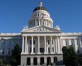
The California State Capitol Museum comprises a museum in and grounds around the California State Capitol in Sacramento, California, USA. The building has been the home of the California State Legislature since 1869. The building underwent a major renovation, known as the California State Capitol Restoration, from 1975 until 1982 to restore the Capitol to its former beauty and to retrofit the structure for earthquake safety. Although not generally considered earthquake country, Sacramento was hit by two earthquakes within days of each other in 1892 which damaged the Capitol.[1] The State Capitol Museum has been a property in the California state park system since 1982.[2]
Capitol Museum
While the entire building may be considered a museum, the heart of the Capitol Museum can be found on the basement and first floor of the original section of the building. In the basement can be found the tour office (B-27), a small theater showing several short films on the history of the Capitol, the gift shop, and the Arthur Mathews mural, the "History of California." On the first floor, visitors can tour the restored historic offices of the Secretary of State, Treasurer, and Governor of California, as well as two rotating exhibit rooms. In the center of the rotunda stands the marble statue, "Columbus' Last Appeal to Queen Isabella," sculpted by Larkin Mead and given to California by banker and philanthropist D.O. Mills in 1883. The museum offers self-guided and guided tours (normally on the hour), and a chance to see the legislature at work when it is in session.
Capitol Park
There are 40 acres (16 ha) of gardens in the surrounding Capitol Park, including trees and shrubs from around the world. There are approximately 1140 trees in the park (not including shrubs) representing over 200 types of trees.
The grounds also feature approximately 155 memorials to significant events and people involving California, and other points-of-interest. Only a selection are listed below, grouped by section, roughly from west to east (9th Street to 15th Street), and then from north (L Street) to south (N Street) within each section:
Between 9th and 10th streets:
- The Earl Warren Walk, dedicated to the former Governor and Chief Justice of the U.S. Supreme Court, marks the path he wore on his walks from the Capitol to the Sutter Club.
- El Soldado Tribute to Mexican American Soldiers[3] of World War II, created at the behest of the Sociedad de Madres Mexicanas, Gold Star mothers.
- The California Peace Officer's Memorial, honoring those officers who have died in the line of duty and remembering those they left behind.
Between 10th and 11th streets:
- California Registered Historical Landmark No. 872, denoting the Capitol Complex as landmark.
- The Great Seal of the State of California, cast in bronze and placed at the west steps in 1952, was followed by the Native American and Spanish-Mexican Commemorative seals in 2002.
- The Capitol Cornerstone, near the north entrance, placed in 1978 to replace the original 1861 cornerstone.
- The Apollo 14 Moon Tree, planted as a sapling in 1976 that was grown from a seed (among hundreds) carried by command module pilot Stuart Roosa during the 1971 mission.
- The Sisters of Mercy Memorial, honoring the religious order which arrived in Sacramento in 1857 to care for the children of miners and to serve the sick and homeless. The land they purchased for the site of a school eventually became the site of the Capitol.
- The September 11 Memorial, including a plaque and three rose bushes, dedicated on the one year anniversary of the attacks.
- The California Civil War Veterans plaque, located at the east entrance, dedicated in 1963 to California veterans of that conflict.
- The U.S. Coast and Geodetic Survey Marker, placed in 1888, is located at 38°34'35"N by 121°29'33"W.
- The Senator Capitol Kitty Memorial, remembering the beloved feline resident of Capitol Park.
Between 11th and 12th streets:
- The Pioneer Camellia Grove created in 1942 by the Native Sons and Daughters of the Golden West in tribute to the pioneers of the city and county of Sacramento.
- A life-sized statue of Junípero Serra, a Roman Catholic missionary sent by Spain to help colonize California. At its base is a map of California's 21 missions, from San Diego to Sonoma.
- Behind Serra's statue stands an El Camino Real Commemorative Bell, placed by the California Federation of Women's Clubs and the California State Automobile Association to celebrate the placing of the original bells along the route in 1906 by the CFWC.
- The Civil War Memorial Grove planted in 1897 with saplings from famous Civil War battlefields.
- Within the grove stands the Reverend Thomas Starr King Memorial, originally one of two statues representing California in Statuary Hall in the U.S. Capitol, but replaced in 2009 by Governor and President Ronald Reagan.
- The Spanish War Veterans Memorial, commonly called "The Hiker," after the appearance of the uniform.
- The ship's bell from USS California, the only dreadnaught-type battleship built on the Pacific Coast. Sunk at Pearl Harbor, she was raised, refitted, and rejoined the fleet in 1944.
- The reproduction of the Liberty Bell, one of fifty-three replicas cast in 1953 as part of a nationwide savings bond drive.
- The World War I Memorial Trees, planted in 1921 in memory of the unknown first California soldier to die in that conflict.
- The Governor Hiram W. Johnson Memorial Parkway, dedicated to the progressive and conservationist Governor.
- The California Department of Transportation Highway Workers Memorial, remembering those CalTrans workers killed in work-related incidents.
- Y-ET-IM TEH-LEI-LI California Indian Grinding Rock[4]
Between 13th and 14th streets:
- The Insectary, constructed in 1908 as a research facility, is now used as a service area for the Department of General Services groundskeeping crew.
- The California Firefighters Memorial erected to honor the fallen firefighter.[5]
- The California Veterans Memorial, a granite obelisk honoring California Veterans from the Mexican–American War, Civil War, Spanish–American War, World War I, World War II, the Korean War, the Vietnam War and the Persian Gulf War.[6]
- By the Veterans Memorial stands the Purple Heart Monument, in honor of those veterans killed, wounded, or disabled in combat.
Between 14th and 15th streets:
- The California Vietnam Veterans Memorial, with life-size bronze figures of service men and women depicting military life in Vietnam and featuring engravings of names of Californians killed or missing in action.[7]
- The World Peace Rose Garden, a 0.42 acre garden with about 650 roses in over 140 varieties of colors and fragrances on display.
- The California Native Plant Section, created in 1911 with the efforts of the Native Sons and Daughters of the Golden West, planted almost exclusively with flora native to the state.
-
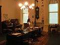
Reconstitution of the office of the California Secretary of State in November 1902
-

A bell from USS California is on display at the California State Capitol Museum.
-

A reproduction of the Liberty Bell is on display at the California State Capitol Museum
-
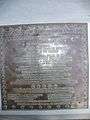
The inscription, which reads, in part: "Dedicated to you, a free citizen in a free land .... In standing before this symbol, you have the opportunity to dedicate yourself, as did our founding fathers, to the principles of the individual freedom for which our nation stands."
-

A statue honoring those who served in the Spanish–American War
See also
References
- ↑ "More Terrestrial Chills – Sacramento Shivers Again, But Not Damaged to Any Extent". The Sacramento Union. April 22, 1892. p. 3. "The Capitol was given a lively shaking, in the course of which a small portion of one of the plaster statuettes tumbled off and the Assembly chamber ceiling cracked. Of course, there was a general exodus of State officials and clerks, too."
- ↑ "California State Park System Statistical Report: Fiscal Year 2009/10" (PDF). California State Parks: 16. Retrieved 2011-10-29.
- ↑ "CalVet – Mexican American Veterans Memorial Committee". Retrieved February 27, 2012.
- ↑ California Indian Grinding Rock
- ↑ California Firefighters Memorial
- ↑ "Memorials". Retrieved February 27, 2012.
- ↑ "California Vietnam Veterans Memorial". Retrieved February 27, 2012.
External links
- El Soldado Memorial
- California Peace Officer's Memorial
- California Firefighters Memorial
- California Vietnam Veterans Memorial
- California State Capitol Museum
- California State Parks' State Capitol Museum page