D. L. Bliss State Park
| D. L. Bliss State Park | |
|---|---|
 | |
  | |
| Location | El Dorado County, California, USA |
| Nearest city | Tahoma, California |
| Coordinates | 38°58′53″N 120°6′2″W / 38.98139°N 120.10056°W / 38.98139; -120.10056Coordinates: 38°58′53″N 120°6′2″W / 38.98139°N 120.10056°W / 38.98139; -120.10056 |
| Area | 2,149 acres (870 ha) |
| Established | 1929 |
| Governing body | California Department of Parks and Recreation |
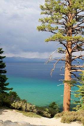
D. L. Bliss State Park is a state park of California in the United States. It is located on the western shore of Lake Tahoe just north of Emerald Bay State Park.
Notable features include Rubicon Point Light, the highest-elevation lighthouse in the United States. A popular trail in the lakeside forest features a large balancing rock.
The park is named in honor of timber and railroad magnate Duane Leroy Bliss, whose heirs donated 744 acres (301 ha) of land to the state in 1929.[1] It has since grown to 2,149 acres (870 ha).[2]
See also
References
- ↑ "D. L. Bliss State Park". California State Parks. Retrieved 2011-12-06.
- ↑ "California State Park System Statistical Report: Fiscal Year 2009/10" (PDF). California State Parks: 32. Retrieved 2011-10-29.
This article is issued from Wikipedia - version of the 11/19/2016. The text is available under the Creative Commons Attribution/Share Alike but additional terms may apply for the media files.