Sierra National Forest
| Sierra National Forest | |
|---|---|
|
IUCN category VI (protected area with sustainable use of natural resources) | |
|
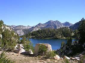
Lake of the Lone Indian, John Muir Wilderness | |
 Map of the United States | |
| Location | Sierra Nevada Mountains |
| Nearest city | Oakhurst, California |
| Coordinates | 37°25′0″N 119°10′0″W / 37.41667°N 119.16667°WCoordinates: 37°25′0″N 119°10′0″W / 37.41667°N 119.16667°W |
| Area | 1,300,000 acres (5,300 km2) |
| Established | 1893 |
| Governing body | U.S. Forest Service |
| Website | Sierra National Forest |
Sierra National Forest is a U.S. National Forest located on the western slope of central Sierra Nevada in the state of California. The forest is known for its mountain scenery and natural resources. Forest headquarters are located in Clovis, California. There are local ranger district offices in North Fork and Prather.[1]
History
Sierra National Forest was the second National Forest created in California and the largest at the time. It covered over six million acres (24,000 km2) of the Sierra Nevada and was about four times the average area of typical California National Forests. Originally it embraced parts of eight counties from Tuolumne on the north to Kern on the south and Mono and Inyo on the east. Initially its name was descriptive, but later when the Sierra was divided into different units this was no longer the case.
President Harrison proclaimed the Sierra Forest Reserve on February 14, 1893. Four years later the south half became a separate unit and was named Sierra South during the "forest reserves" era. This designation was dropped after the administrative transition to the National Forests on March 4, 1907. On July 1, 1908, the Sequoia National Forest, Kings Canyon and Sequoia National Parks were established from this south portion of Sierra National Forest. Eastern portions of Sierra National Forest became the Inyo and Toiyabe National Forests; northern portions were used for Yosemite National Park and the Stanislaus National Forest.
The first timber sale on a California National Forest took place in the Sierra NF by the General Land Office in 1899.[2]
Geography
Sierra National Forest covers, in descending order of forestland area, the eastern portions of Fresno, Madera, and Mariposa counties, adjacent to the southern part of Yosemite National Park. It includes more than 1,300,000 acres (2,000 sq mi; 5,300 km2), at altitudes ranging from 900 to 13,986 feet (274 to 4,263 m) in elevation. The terrain includes rolling, oak-covered foothills, heavily forested middle elevation slopes and the tundra landscape of the High Sierra.
Boundaries
The forest's boundary starts clockwise at the intersections of the Merced River, Sweetwater Creek and HWY 140, then moves east following the Merced River canyon to the border with Yosemite National Park near El Portal. Then it follows the park's southern boundary till it reaches the Inyo National forest near Electra Peak. From there it travels south to its border with Kings Canyon National Park near Mount Goethe. It follows the park's northern border, then heads south to the Kings River near Deer Canyon. From there it moves down the Kings River canyon east; south of the river is the Sequoia National Forest. When it reaches Pine Flat Lake near Trimmer, it turns north towards Tollhouse and continues on to Auberry. From there Sierra National Forest moves on to North Fork, then west to form a small finger towards Coarsegold. Finally, the boundary travels north to Yosemite Forks and moves west towards Miami Mountain, then heads north to return to the Merced River.
Recreation
The forest includes a number of scenic attractions, including Fresno Dome and Nelder Grove. Several reservoirs offer fishing, including Bass Lake, Wishon Reservoir, and Courtright Reservoir. There are numerous hiking opportunities in wilderness areas: Ansel Adams, John Muir, Dinkey Lakes, Kaiser, and Monarch. It also has a ski area, China Peak, that operates under a special use permit.
Administration
The Sierra National Forest is located within the Pacific Southwest region of the US Forest Service. The forest is divided into three Ranger Districts:
Bass Lake Ranger District is north and west of the San Joaquin River. Its Ranger District office is located at 57003 Road 225 North Fork, California, CA 93643. There are 36 camp sites, 17 picnic sites, 7 Off Highway Vehicle Trails, and 10 trails. It includes the Forest Service Offices of Oakhurst (41969 Hwy 41, Oakhurst, California 93644), and Mariposa (5158 Suite A Highway 140 Mariposa, California 95338), and the Clover Meadow Wilderness Office.
High Sierra Ranger District is south and east of the San Joaquin River; it has its Ranger District office out of 29688 Auberry Rd P.O. Box 559 Prather, California 93651. This district contains 30 camp sites, 11 picnic sites, and 13 Off Highway Vehicle Trails. It alsi includes the following Forest Service Offices; the High Sierra visitor information station near Mono Hot Springs on the Kaiser Pass Road, Eastwood visitor information center at Hwy 168 and Kaiser Pass Road at Huntington Lake, Dinkey Creek visitor information center on Dinkey Creek Road near the Dinkey Creek Campground,
Supervisor's Office (an administrative Unit) contains the Sierra National Forest Supervisor's office (1600 Tollhouse Rd Clovis, California, 93611); the Mariposa Interagency Visitor Center (5158 Highway 140 Mariposa, California 95338) and the Yosemite Sierra Visitor Bureau (41969 Highway 41, Oakhurst, California 93644); and the Fresno Air Attack Base which is co-located with the Sierra National Forest Emergency Communications Center (2307 and 2309 N Clovis Ave, Fresno, California 93727) at Fresno Yosemite International Airport.
In addition, the forest has a close relationship with the Teakettle Experimental Forest which is deep inside the forest and the San Joaquin Experimental Range which is just outside the forest boundaries. They both fall in the Pacific Southwest Research Station which is based in Berkeley, California.[3]
Ecology
The ecology of the National Forest is typical for the western side of the southern Sierra Nevada: distributions of species are largely governed by climate, which is strongly dependent on altitude. The ecology can be described by biotic zones, which are marked by either a tree indicator species, or by a lack of trees. The biotic zones include the foothill woodland zone from 1,000 to 3,000 feet (300 to 910 m) (interior live oak), the lower montane zone from 3,000 to 7,000 feet (910 to 2,130 m) (Ponderosa pine), the upper montane zone from 7,000 to 9,000 feet (2,100 to 2,700 m) (lodgepole pine/red fir), the subalpine zone from 9,000 to 9,500 feet (2,700 to 2,900 m) (whitebark pine), and the alpine zone from 9,500 feet (2,900 m) (above the tree line).[4]
Some 383,000 acres (598 sq mi; 1,550 km2) of the forest are old growth, containing lodgepole pine (Pinus contorta) and red fir (Abies magnifica).[5]
See also
- List of plants of the Sierra Nevada (U.S.)
- Sierra National Forest index
- Sierra Nation Forest Fire & Aviation Management
References
- ↑ USFS Ranger Districts by State
- ↑ Godfrey, Anthony The Ever-Changing View-A History of the National Forests in California USDA Forest Service Publishers, 2005 p. 92
- ↑ Weekly Recreation Report
- ↑ Schoenherr, Allan A. (1992). A Natural History of California. University of California Press. ISBN 0-520-06922-6.
- ↑ Warbington, Ralph; Beardsley, Debby (2002). 2002 Estimates of Old Growth Forests on the 18 National Forests of the Pacific Southwest Region. United States Forest Service, Pacific Southwest Region.
External links
| Wikimedia Commons has media related to Sierra National Forest. |